
Super typhoon Utor has entered the South China Sea, becoming typhoon number 7.
This afternoon (August 12th), Typhoon Utor crossed Luzon Island (Philippines) and entered the eastern part of the North East Sea, becoming the 7th typhoon of the year.
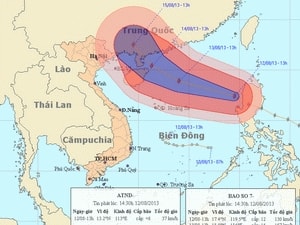
The storm's path and location. (Source: nchmf.gov.vn)
At 13:00, the typhoon's center was located at approximately 17.4 degrees North latitude and 119.5 degrees East longitude, about 780km east of the Hoang Sa (Paracel) Islands. The strongest winds near the center of the typhoon were at level 12 or 13 (118 to 149 km/hour), with gusts reaching level 15 or 16.
The forecast for the next 24 hours indicates the storm will move in a direction between west and west-northwest, traveling at approximately 20-25 km per hour, and may intensify further.
As of 13:00 on August 13th, the typhoon's center was located at approximately 18.9 degrees North latitude and 114.0 degrees East longitude, about 300km northeast of the Hoang Sa (Paracel) Islands. The strongest winds near the center of the typhoon reached level 14 (150-166 km per hour), with gusts reaching levels 16 and 17. Over the next 24 to 48 hours, the typhoon is likely to change direction, moving between west-northwest and northwest at a speed of approximately 10-15 km per hour.
As of 13:00 on August 14th, the typhoon's center was located at approximately 20.4 degrees North latitude and 111.3 degrees East longitude, northeast of Hainan Island (China). The strongest winds near the center of the typhoon reached level 14 (150 to 166 km/hour), with gusts reaching levels 16 and 17. Over the next 48 to 72 hours, the typhoon is likely to change direction and move northwest at a speed of approximately 10-15 km/hour.
Due to the influence of the storm, the eastern part of the North East Sea will experience strong winds of force 9-10, later increasing to force 11-12, with winds near the storm's center reaching force 13-14, gusting to force 16-17. The sea will be extremely rough. From tomorrow morning (August 13th), the northeastern part of the Hoang Sa archipelago will experience gradually increasing winds of force 8-9, later increasing to force 10-11, gusting to force 12-13. The sea will be extremely rough.
Furthermore, after changing direction eastward, the tropical depression weakened into a low-pressure area this afternoon. At 1 PM, the center of the low-pressure area was located at approximately 13.2 degrees North latitude and 113.0 degrees East longitude, over the sea north of the Truong Sa archipelago. Forecasts indicate that over the next 12 hours, this low-pressure area will continue to move eastward at a speed of about 10-15 km per hour, weakening and gradually dissipating.
Due to the influence of a low-pressure system combined with strong southwest monsoon winds, the central and southern areas of the East Sea (including the waters around the Spratly Islands), and the sea area from Binh Thuan to Ca Mau will experience strong winds of level 6, gusting to levels 7 and 8, along with heavy rain and thunderstorms. The sea will be rough. Tornadoes should be anticipated during thunderstorms. The southern provinces and the Central Highlands will experience rain, moderate rain, with some areas experiencing heavy rain and scattered thunderstorms.
The Central Steering Committee for Flood and Storm Prevention - National Committee for Search and Rescue issued Official Dispatch No. 45/CĐ-TW on August 11, 2013, to provinces from Quang Ninh to Phu Yen and relevant ministries and agencies, directing measures to respond to the tropical depression in the East Sea and Typhoon No. 7.
The Standing Office of the Central Steering Committee for Flood and Storm Prevention regularly urges provinces to strictly implement the contents of official dispatches and report on the situation of rain, floods, and dike incidents. The General Staff of the Border Guard Command has issued an official dispatch directing border guards in coastal provinces and cities from Quang Ninh to Ca Mau and the three naval squadrons 18, 38, and 48 to direct the deployment of measures to cope with the low pressure system in the East Sea and Typhoon No. 7. The Ministry of Health and the Ministry of Public Security have issued official dispatches directing relevant units to deploy measures to cope with the low pressure system in the East Sea and Typhoon No. 7.
The Steering Committee for Flood and Storm Prevention and Search and Rescue in the provinces and cities of the Northern region continues to vigorously implement flood control measures according to the alert level, protect inland irrigation works, and prevent waterlogging to save rice crops. The provinces and cities of Thai Binh, Nam Dinh, Nghe An, Quang Nam, and Phu Yen have issued directives and announcements instructing measures to respond to the low pressure system and Typhoon No. 7.
According to a quick report dated August 12th from the Standing Agency of the Steering Committee for Flood and Storm Prevention and Search and Rescue/Border Guard, as of the afternoon of August 12th, the Border Guard along the coast of provinces from Quang Ninh to Ca Mau had coordinated with local authorities, ship owners' families, and captains to inform, count, and guide 64,295 vessels/270,993 people about the location and direction of movement of the low pressure system and Typhoon No. 7 so that they could proactively move to avoid it.
According to a quick report from the Khanh Hoa Border Guard Command, as of now, the province still has 425 vessels with 3,674 crew members fishing in various sea areas across the country. All vessels and crew members are aware of the trajectory of Typhoon No. 7 and the low-pressure system to proactively take preventive measures. The remaining vessels from the province have anchored at ports and harbors.
The Khanh Hoa Provincial Border Guard Command has directed its watch stations to maintain a strict 24/7 duty schedule; continuously updating and disseminating information about Typhoon No. 7 and the tropical depression on various communication frequencies so that vessel owners know the direction, can proactively move, and find safe shelter. Border Guard Squadron 2 maintains a duty shift, consisting of two vessels and a crew of 16 soldiers. Units are compiling statistics and counting the number of people and vessels currently fishing in the sea area; coordinating with local authorities to inform vessels operating at sea about the direction of Typhoon No. 7 and the tropical depression so they can proactively take preventive measures.
According to VNA - LT


