Landslide incident in Hung Nguyen: need to review key locations
(Baonghean) - About more than 100m of road at section Km4+40 to Km4+500n Project to upgrade and expand the traffic route from the General Secretary Le Hong Phong Relic Site (Hung Thong Commune) to Hung Nhan Commune, Hung Nguyen Districtlandslide, broken, seriously damaged
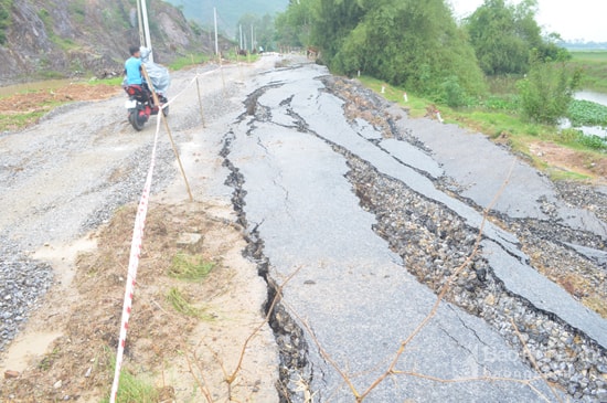
| Landslide on the road from Hung Thong commune to Hung Nhan commune. |
Current status of landslides
The incident occurred on September 30, 2017, and up to now, the scene of the landslide is still intact. This shows that this is a serious traffic damage incident. The road surface is about 6m wide, the remaining part, about 1/3, still has cracks stretching for dozens of meters; the other part, has broken open, and has fallen several meters deep into the irrigation canal.
Inquiring from the people of Hung Nguyen district who frequently travel this route, they said that this is the road connecting the communes of Hung Thong, Hung Tien, Hung Chau, Hung Nhan. The road has been in use for a long time, has been repaired many times and has been asphalted. In 2015 - 2016, the State invested funds to upgrade and expand it. However, it is not clear why, after being put into use for a short time, such terrible cracking and landslides have occurred.
Checking the details of the collapsed roadbed, it is easy to identify the old roadbed as people have reported. The structure of the old roadbed consists of crushed stone and asphalt about 20 - 30 cm thick. As for the structure of the newly upgraded road surface at the landslide point, it shows that the construction unit has spread a layer of crushed stone about 30 cm thick on the old road surface; then, a layer of crushed stone and asphalt about 3 - 5 cm thick is spread.
Observing with the naked eye, we can see that the road where the landslide occurred is about 500m long, located on a rather complex terrain. On one side is a rocky mountain with a relatively large slope, on the other side is an irrigation canal about 20m wide, about 6-8m deep.
| The project to upgrade and expand the traffic route from the General Secretary Le Hong Phong Relic Site in Hung Thong Commune to the Pham Hong Thai Relic Site (Hung Nguyen) was approved by the Provincial People's Committee in Decision 4876/QD.UBND-GT dated October 26, 2015. This is a level VI traffic project in the delta, with a length of 5.44km, invested by the People's Committee of Hung Nguyen District; the total investment is 68 billion VND. Vinh Phat Construction Investment and Design Consulting Joint Stock Company is the contractor for design survey and cost estimate. Tan Nam Construction Joint Stock Company is the contractor. Up to now, the project has completed about 80% of the volume; about 70% has been disbursed. |
What does the industry say?
On October 2, the People's Committee of Hung Nguyen district issued Report No. 1074/UBND.DA to the Provincial People's Committee, thereby proposing that the Provincial People's Committee direct the relevant agencies to inspect, review and propose solutions. On October 3, 2017, the Provincial People's Committee issued Official Dispatch No. 7576/UBND-CN assigning the Department of Transport to preside over the inspection of the proposal of the People's Committee of Hung Nguyen district.
To carry out the task in Official Dispatch No. 7576, the Department of Transport requested the investor to direct the design consultant to go to the site to drill 5 drills on 3 cross-sections to determine the exact cause.
From the exploratory drilling, in Report No. 3082/SGTVT-QLCL sent to the Provincial People's Committee on October 9, 2017, the Department of Transport concluded: "Through the results of geological drilling, along with on-site examination, and a number of related documents, it can be seen that a number of unfavorable factors combined together lead to landslides as follows: Through the geological manifestations at the boreholes, it shows that the roadbed is located on a rock slope with a slope towards the canal; moreover, the roadbed is clay and clay mixed with gravel, which is a type of soil with a large expansion coefficient and the internal friction angle of the soil decreases sharply when exposed to water, weakening the contact layer between the embankment on the rock, making it very susceptible to sliding, leading to landslides when it rains frequently;
In recent times, heavy rains have caused water in the canal to seep into the roadbed. When the rain stops, the water in the canal drains quickly, but the amount of water seeping into the roadbed has not yet drained away, causing an imbalance in pressure combined with unfavorable terrain and geological factors as mentioned above, leading to landslides. On the other hand, due to people leveling the ground (according to the investor's report), water stagnates in the ditch on the mountain side, contributing to water seeping into part of the roadbed.
Also in Report 3082/SGTVT-QLCL, the Department of Transport informed that the route was designed mainly to widen and strengthen the structure on the old road surface. For the section where the landslide occurred, the design was to widen and strengthen the old road surface with an average height of 30 - 50cm compared to the old road surface, the centerline of the route was shifted towards the mountain by 2.5m to have enough width, the roadbed on the canal side remained in its current state, not widened. The section where the landslide occurred, the roadbed and surface were accepted by the investor as completed on June 11, 2016. Through checking some locations of the thickness of the road surface structure at the landslide section, it was shown that the construction unit ensured according to the design documents.
At the same time, the proposed solution is to request the Provincial People's Committee to allow the construction of a concrete retaining wall on the canal bank with a foundation embedded in the rock to stabilize the slope. Dig out and replace all the collapsed soil, replace it with soil with good drainage and compact the roadbed according to regulations.
Worry about the road close to the mountain and canal
Although the Department of Transport has identified the cause of the landslide and the solution to fix the problem. However, one concern is why, before construction, the design consultant did not discover that this road was located on such an unfavorable terrain and position in order to find a solution?
According to the representative of the relevant agency, the geological survey work was fully carried out by the design consultant. That is, 1 km of road has drilled 2 geological exploration boreholes; there is a detailed report of each borehole location, assessed and approved by specialized units. Adjacent to the location, there is 1 exploration borehole.
 |
| On the remaining road surface at the landslide site, there are still large cracks. |
Through the archived records, the geological survey work was ensured to be in accordance with regulations. However, from the scene of the landslide, it can be seen that the survey of terrain, topography and implementation of geological survey were still subjective.
This is a road with a landslide point located close to a steep rocky mountain; besides, it is also located next to a large and deep irrigation canal. With such a terrain and topography, it is necessary to evaluate it separately; request the competent authority to allow a geological survey as for a mountain road, and propose the most optimal solution.
Therefore, this is clearly a lesson in transport infrastructure construction that needs to be seriously learned by relevant parties.
In reality, there is an issue that needs further discussion: the entire road where the landslide occurred is in a complex location, close to the mountain and the canal with a total length of about 500m. Currently, more than 100m has been lost, will the remaining part of about 400m be safe when the weather continues to get worse and floods occur continuously?
Therefore, it is recommended that the Provincial People's Committee direct the investor and design consultant to review the entire route, make specific assessments and reports.
In case of detecting any abnormalities, promptly propose solutions to the competent authority, thereby ensuring traffic safety and preventing incidents like the recent one.
PV Group
| RELATED NEWS |
|---|