Weather June 17: Nghe An warns of heavy rain, thunderstorms and tornadoes
(Baonghean.vn) - Due to the influence of the low pressure trough analyzed above, which is still active, combined with wind convergence at an altitude of 1,500m, Nghe An will have moderate to heavy rain. During thunderstorms, there is a possibility of tornadoes, hail, and strong gusts of wind. Natural disaster risk level: level 1.
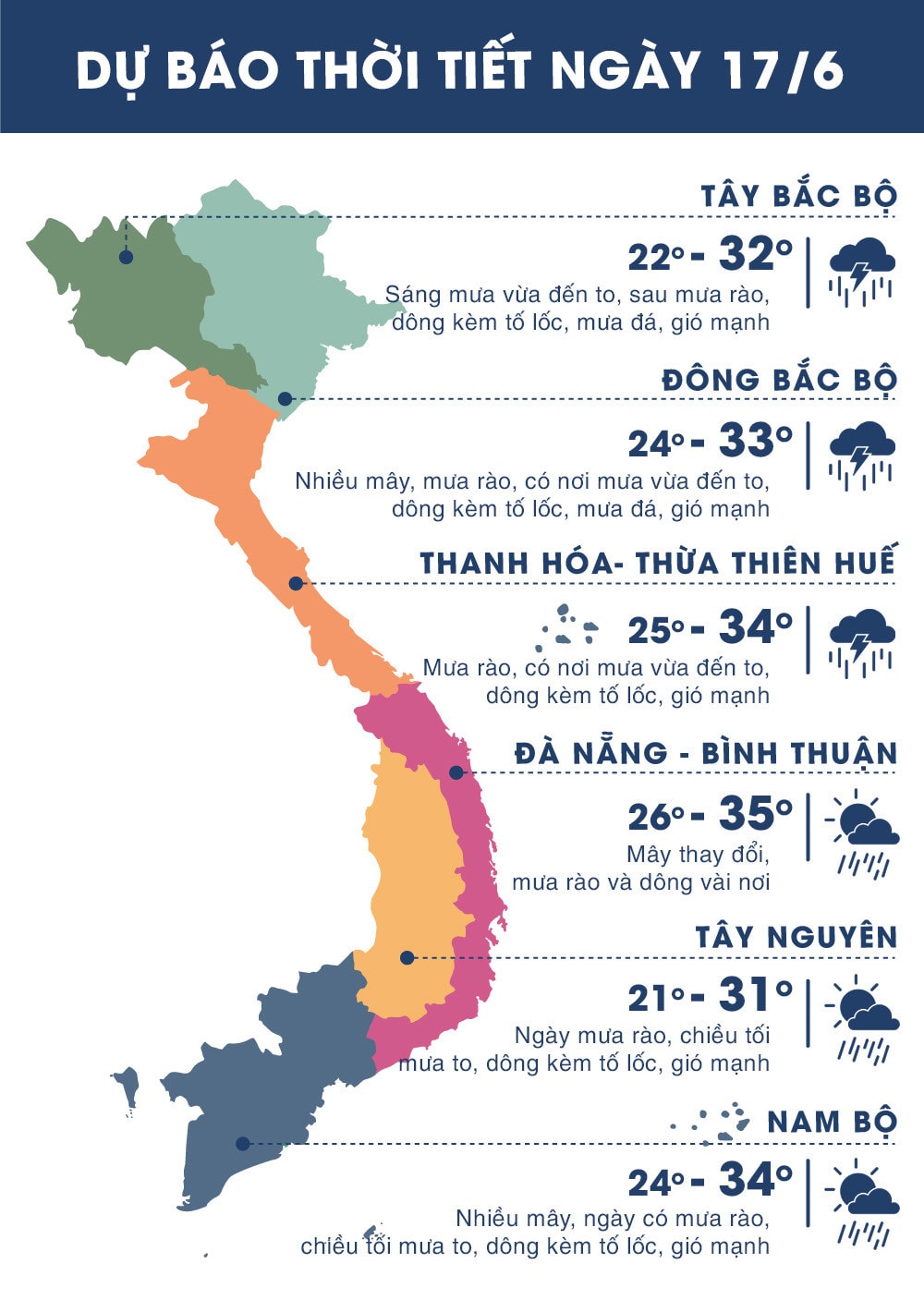
Currently (June 17),Low pressure trough with axis at about 18-21 degrees North latitude continues to be active in the Northern region.
 |
| Nghe An warns of heavy rain, thunderstorms and tornadoes. Photo courtesy |
Forecast:Due to the influence of the low pressure trough analyzed above, which is still active, combined with wind convergence at an altitude of 1,500m, tonight in the North and North Central regions, there will continue to be showers and thunderstorms in many places; especially in the provinces in the Northwest, the Northern Delta, Thanh Hoa, and Nghe An, there will be moderate to heavy rain. During the thunderstorms, there is a possibility of tornadoes, hail, and strong gusts of wind.Disaster risk level: level 1.
Due to the influence of the southwest monsoon which is gradually strengthening, in the next 2-3 days in the Central Highlands and the South, there will be rain, moderate rain, heavy rain in some places and scattered thunderstorms. During the thunderstorms, there is a possibility of tornadoes, hail and strong gusts of wind. Heavy rain will occur mainly in the afternoon and evening.
 |
| Source zing.vn |
Weather forecast at sea: Warning of thunderstorms, strong winds, high waves
Currently (June 17):Due to the influence of the low pressure trough with its axis at about 18-21 degrees North latitude, there are strong thunderstorms in the Gulf of Tonkin and the North East Sea. In the South, the Southwest monsoon is gradually becoming stronger.
Forecast:Due to the influence of the low pressure trough with its axis at about 18-21 degrees North latitude, from now until June 19, in the North East Sea area (including Hoang Sa archipelago), there will continue to be thunderstorms, with the possibility of tornadoes and strong gusts of wind of level 7-8; waves from 2.0-3.5m high; rough seas.Disaster risk level: level 1.
In the Gulf of Tonkin there are scattered showers and thunderstorms. During thunderstorms there is a possibility of tornadoes and strong gusts of wind.
During the day and tonight (June 17), in the sea area from Binh Thuan to Ca Mau, there will be strong southwest winds of level 5, sometimes level 6, gusting to level 8; rough seas. The sea area from Ba Ria-Vung Tau to Ca Mau, Ca Mau to Kien Giang and the Gulf of Thailand will have showers and strong thunderstorms, with the possibility of tornadoes and strong gusts of level 7.Disaster risk level: level 1.