Central Vietnam Weather: Hot in some places, continued showers and thunderstorms in others
(Baonghean.vn) - According to the National Center for Hydro-Meteorological Forecasting, from Thanh Hoa to Thua Thien Hue, the clouds will change, with showers and thunderstorms in some places. Meanwhile, from Da Nang to Binh Thuan, the clouds will change, with sunny days and hot weather in some places, and showers and thunderstorms in some places in the evening and at night.
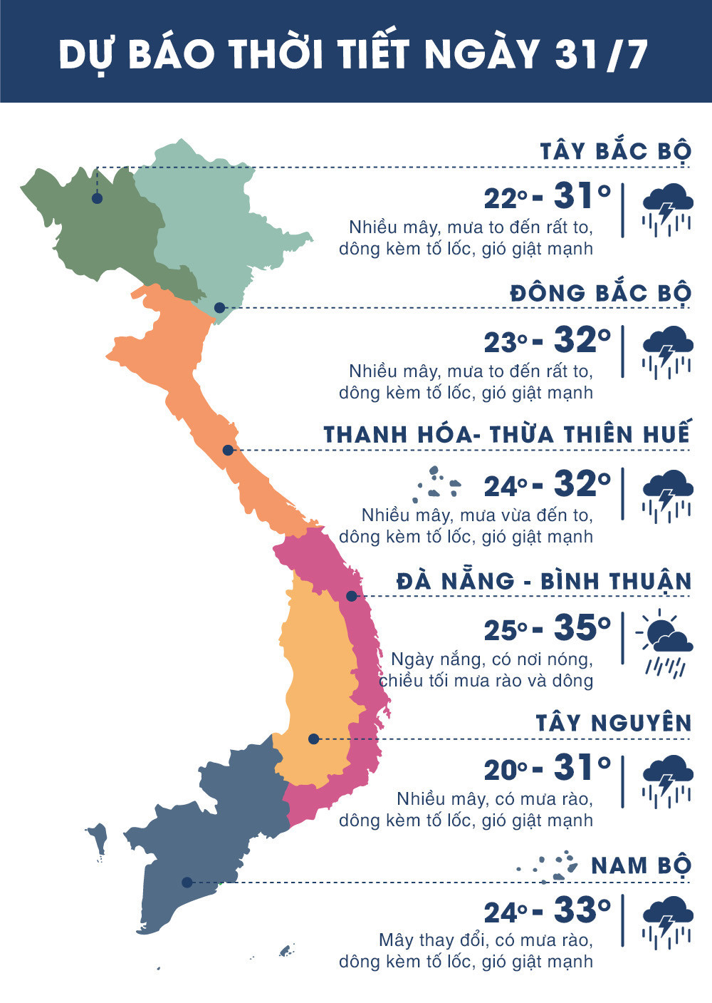 |
| Temperature forecast for regions across the country on July 31, 2018. Photo: news.zing.vn |
Widespread heavy rain in the North
Due to the influence of the tropical convergence zone, during the day and night of yesterday (July 30), in the Northern and North Central provinces, there was rain, moderate rain, and in some places heavy rain to very heavy rain such as in Tam Duong (Lai Chau) 78mm, Pha Din (Dien Bien) 57mm, Bac Yen (Son La) 53mm, Luc Ngan (Bac Giang) 58mm, Ha Dong (Hanoi) 79mm, Chi Linh (Hai Duong) 35mm, Quynh Luu (Nghe An) 46mm,...
Present (July 31):The tropical convergence zone with its axis passing through the Southern Red River Delta region is gradually weakening.
Forecast:Due to the influence of the tropical convergence zone that is moving north and continuing to weaken, today and tonight in the midland and mountainous provinces of the North there will be rain, moderate rain, especially in the Northeast and Viet Bac, there will be places with heavy rain and thunderstorms. During the thunderstorms there is a possibility of tornadoes, whirlwinds and strong gusts of wind.
From tomorrow (August 1), heavy rain in the North will decrease rapidly.
BesidesDue to the influence of the tropical convergence zone with the strong southwest monsoon, during today and tonight, in the South East Sea area (including the sea area of Truong Sa archipelago) and the sea area from Binh Thuan to Ca Mau, there will continue to be strong southwest winds at level 5, sometimes level 6, gusting to level 8, waves 2-3m high; rough seas.
FLASH FLOOD AND LANDSLIDE WARNING
HA GIANG:
Rainfall measured from 2:00-3:00 a.m. on July 31 at Na Tri station in Xin Man was 30.6 mm, Thong Nguyen station in Hoang Su Phi, Ha Giang province was 29.4 mm.
Comments:In the next 3 hours, this area will continue to have rain with total rainfall likely reaching 10-30mm.
Warning:In the next 3-6 hours, flash floods and landslides are at risk in the districts of Xin Man and Hoang Xu Phi (Ha Giang). Disaster risk warning level: level 1.
SON LA:
Rainfall measured from 10:45 p.m. to 11:30 p.m. on July 30 at Bac Yen station in Son La province was 28 mm, and Quy Hoa station in Hoa Binh was 30 mm.
Comments:In the next 3 hours, this area will continue to have rain with total rainfall likely reaching 10-30mm.
Warning:In the next 3-6 hours, landslides are at risk of occurring in Bac Yen district (Son La). Disaster risk warning level: level 1.