Latest information on tropical depression on land
(Baonghean.vn) - According to the National Center for Hydro-Meteorological Forecasting, the tropical depression is forecast to move deep inland, weaken into a low-pressure area and move towards the Vietnam-China border.
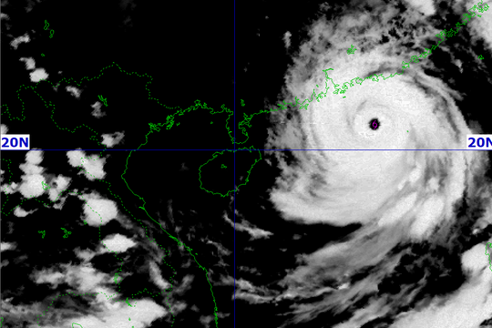
4 o'clock, the center of the tropical depression is located at about 21.4 degrees North latitude; 110.2 degrees East longitude, in the area north of Leizhou peninsula (China). The strongest wind near the center of the tropical depression is level 6 (40-50km/hour),level 8 jerk. The range of strong winds of level 6, gusting to level 8 is about 50km from the center of the tropical depression.
Dangerous areas at sea in the next 24 hours(strong wind level 6): Northeast area of the Gulf of Tonkin (east of 108.5 degrees East longitude; north of 20.0 degrees North latitude).
 |
| Satellite cloud image. Photo: National Center for Hydro-Meteorological Forecasting |
Forecast for the next 24 hours,The tropical depression is moving in the West Northwest direction, traveling 10-15km per hour. At 4:00 a.m. on July 25, the center of the tropical depression was at about 22.8 degrees North latitude; 107.0 degrees East longitude, on the mainland southwest of Guangxi province (China). The strongest wind near the center of the tropical depression is level 6 (40-50km/hour).level 8 jerk. The range of strong winds of level 6, gusting to level 8 is about 50km from the center of the tropical depression.
Due to the influence of low pressure in the Northeast of Bac Bo Gulf with strong winds of level 6,level 8 jerkand there was heavy rain and thunderstorms; rough seas.Disaster risk level: level 3.
Over the next 24 to 36 hours,The tropical depression moved in a West-Northwest direction, traveling 15-20km per hour, and weakened into a low-pressure area on the Vietnam-China border area.
BesidesDue to the influence of the tropical convergence zone combined with the strong southwest monsoon, today and tonight (July 24), in the Central and Southern East Sea (including the sea area of Truong Sa archipelago), the sea area from Binh Thuan to Ca Mau continues to have strong southwest winds at level 6, gusting to level 8, waves from 2-3m high; rough seas.Disaster risk level: level 1.
Weather today (July 24) from Thanh Hoa to Binh Thuan:
Thanh Hoa - Thua Thien Hue area:Cloudy, sunny during the day, showers and thunderstorms in some places in the evening and at night. Southwest wind level 2-3. Humidity 55-95%
Lowest temperature from: 24-27oC
Highest temperature from: 32 to 35 degrees, some places over 35oC
Da Nang - Binh Thuan area:Cloudy, sunny during the day, showers and thunderstorms in some places in the evening and at night. Southwest wind level 2-3. Humidity 60-95%
Lowest temperature from: 26-29oC
Highest temperature from: 31-34oC
Heavy rain in the North
From July 25-26, heavy rain will spread to the entire mountainous and midland areas of the North, with heavy to very heavy rain on July 25-26 concentrated in the provinces of Cao Bang, Ha Giang, Lao Cai, Yen Bai, and Lai Chau (50-150mm/day).
Disaster risk level due to heavy rain: level 1, especially in the provinces of Cao Bang, Ha Giang, Lao Cai, Yen Bai, Lai Chau: level 2.
Warning:From July 27, heavy rain in the mountainous and midland areas of the North tends to spread to the Northern Delta provinces and Thanh Hoa and is likely to last until early August.


.jpg)


