
News about the tropical depression in the East Sea.
(Baonghean.vn) - This morning (September 13), the low-pressure area over the East Sea has strengthened into a tropical depression.
According to the North Central Vietnam Meteorological and Hydrological Station, at 8:00 AM, the center of the tropical depression was located at approximately 15.0 degrees North latitude and 113.5 degrees East longitude, in the southeastern sea area of the Hoang Sa archipelago. The strongest winds near the center of the tropical depression were at level 6 (40 to 50 km per hour), with gusts at levels 7 and 8.
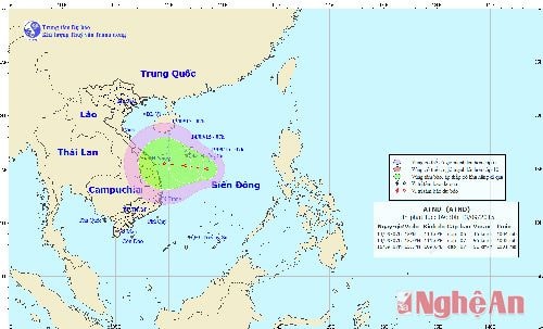 |
Forecast for the next 24 hoursThe tropical depression is moving in a west-northwest direction at a speed of approximately 5-10 km per hour and is tending to strengthen. By 07:00 on September 14th, the center of the tropical depression will be located at approximately 15.2 degrees North latitude; 111.6 degrees East longitude, in the sea south of the Hoang Sa archipelago. The strongest winds near the center of the tropical depression are at force 6-7 (40-60 km per hour), with gusts of force 8-9.
Due to the influence of the tropical depression, the northern South China Sea area (including the waters around the Hoang Sa archipelago) will experience strong winds of force 6-7, gusting to force 8-9; rough seas. Disaster risk level: level 3.
Over the next 24 to 48 hours,The tropical depression continues to move westward at a speed of about 10 km per hour and is tending to intensify.
Due to the influence of the northern edge of the low-pressure trough connected to the center of the tropical depression, the northern part of the North Central provinces will experience rain, showers, and thunderstorms in some areas; the southern part will have moderate rain, with some areas experiencing heavy to very heavy rain and thunderstorms.
Ha Chi


