Storm news near the East Sea, typhoon Koinu
(Baonghean.vn) - In the next 24 to 48 hours, the storm will move in the West Northwest direction, at a speed of about 10km/h... Meanwhile, the weather forecast for Nghe An on October 4 is sunny, with showers and thunderstorms in some places in the late afternoon and at night, and light winds.
STORM NEWS NEAR THE EAST SEA (STORM KOINU)
Storm status:According to the National Center for Hydro-Meteorological Forecasting, at 1:00 a.m. on October 4, the center of the storm was located at about 21.9 degrees North latitude; 124.2 degrees East longitude, in the sea southeast of Taiwan Island (China), about 330km East Southeast of Taiwan Island. The strongest wind near the center of the storm was level 14 (150-166km/h), gusting to level 17, moving northwest at about 10km/h.
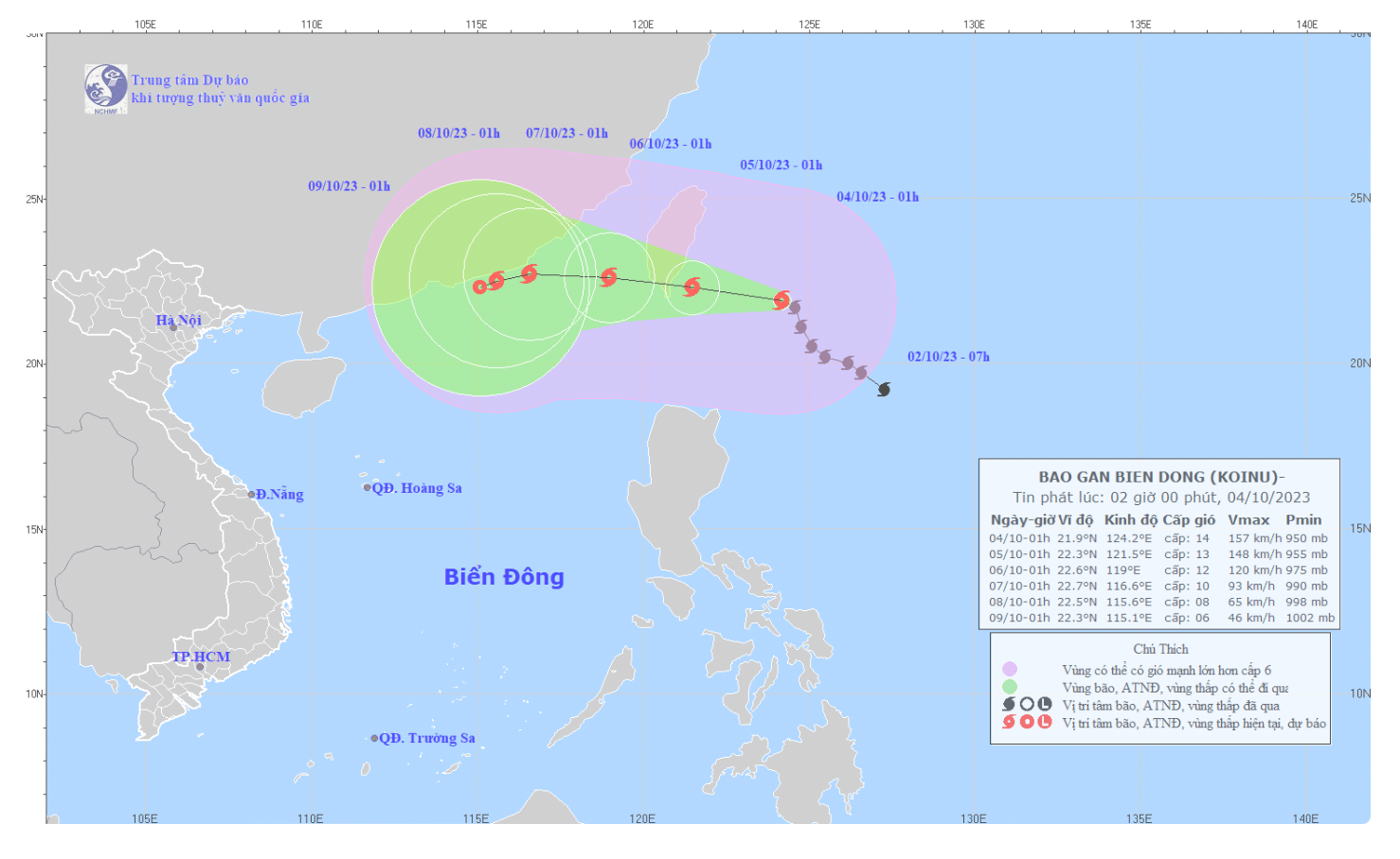
Storm forecast (Next 24 to 72 hours):
| Forecast time | Direction, speed | Location | Intensity | Danger zone | Disaster Risk Level (Affected Area) |
| 01h/05/10 | West Northwest, about 10km/h | 22.3N-121.5E, in the waters south of Taiwan | Level 13, level 16 | 20.0-25.0N; East of longitude 119.0E | Level 3:southeast of Taiwan, northeast of the North East Sea area |
| 01h/06/10 | West Northwest, about 10km/h moving into the East Sea and gradually weakening | 22.6N-119.0E, 270km East Southeast of Fujian (China) | Level 11-12, level 15 jerk | North of latitude 20.0N; East of longitude 117.0E | Level 3:Northeast of the North East Sea area |
| 01h/07/10 | West, about 10km/h and gradually weakening | 22.7N-116.6E, in the sea southeast of Guangdong province (China) | Level 9-10, level 12 | North of latitude 20.0N; East of longitude 114.5E | Level 3:North of the North East Sea area |
Storm warning (from 72 to 120 hours):From the next 72 to 120 hours, the storm will move mainly in the West Southwest direction, about 5km per hour, and its intensity will continue to weaken.
Forecast of storm impact:
Strong winds at sea:The northeastern sea area of the North East Sea has strong winds of level 6-7, from the night of October 4, they will strengthen to level 8-10, the area near the storm's eye will have winds of level 11-12, gusting to level 15; the sea will be very rough.
Rising water, big waves:The northeastern sea area of the North East Sea has waves 2.0-4.0m high; from the night of October 4, the waves are 4.0-6.0m high, and the area near the storm center has waves 6.0-8.0m high.
FORECASTWEATHER ON LAND IN NGHE AN PROVINCE
(Day and night October 4)
* Coastal plain area
Cloudy. Sunny day, no rain at night. Wind east to southeast force 3.
- Temperature: 26 – 33 degrees Celsius
- Humidity: 70 – 80%
* Midland and mountainous areas
Cloudy. Sunny during the day, with scattered showers and thunderstorms in the evening and at night. Light wind.
- Temperature: 25 – 34 degrees Celsius
- Humidity: 70 – 80%
* Vinh city area
Partly cloudy, no rain. Sunny day. East to southeast wind force 2-3.
- Temperature: 27 – 33 degrees Celsius
- Humidity: 70 – 75%
* Cua Lo and Ngu Island area
Cloudy. Sunny day, no rain at night. Wind east to southeast force 3.
- Temperature: 26 – 31 degrees Celsius
- Humidity: 75 – 80%
* Next 48 hours:Continental high pressure weakens, the tropical convergence zone with its axis through the South and Central Central regions gradually lifts its axis to the North, subtropical high pressure tends to encroach on the West so clouds change, sunny during the day, showers and thunderstorms in some places in the evening and at night, light wind.
* During thunderstorms there is a possibility of tornadoes, lightning, hail and strong gusts of wind.