Emergency storm warning: Typhoon BUALOI (Typhoon No. 10), Category 12, gusts up to Category 15, is heading towards Nghe An and northern Quang Tri.
The storm's center is currently in the sea area between Quang Tri and Da Nang, moving very quickly and is forecast to cause a dangerous combination of strong winds, high waves, storm surge, and extremely heavy rain, threatening provinces from Thanh Hoa to Da Nang.
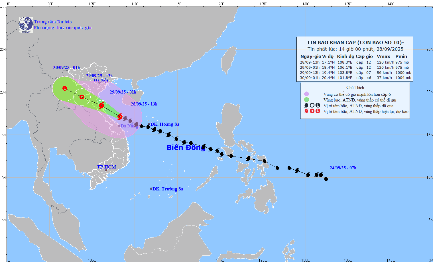
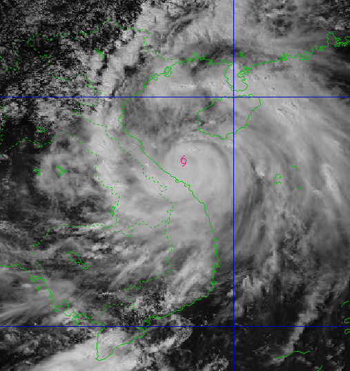
According to the latest update at 3 PM on September 28th, the center of Typhoon No. 10 is located at approximately 17.3 degrees North latitude and 107.9 degrees East longitude. The typhoon is currently about 85km northeast of Hue city and about 140km south-southeast of northern Quang Tri province. The strongest winds near the center of the typhoon remain at level 12 (118-133 km/h), with gusts up to level 15.
The storm is moving rapidly in a west-northwest direction at a speed of approximately 20-25 km/h. This is a fast-moving, strong storm with a wide area of impact, potentially causing a combination of natural disasters such as strong winds, heavy rain, floods, flash floods, landslides, and coastal flooding.
Forecasting the development and warning of natural disaster risks.
| Time | Direction, speed | Location | Intensity | Level of natural disaster risk (Affected area) |
| 1:00 AM on September 29th | West-Northwest, 20-25 km/h | Along the coastal region of Nghe An - northern Quang Tri | Level 12, then level 15 | Level 4: Coastal mainland area from Nghe An to northern Quang Tri. |
| 13:00 on September 29th | West-northwest, 20-25 km/h, moving inland and gradually weakening. | Over the Upper Laos region (tropical depression) | Level 7, bursts up to level 9. | Level 3: The sea area from Thanh Hoa to Hue city. |
High risk warning: Strong winds, storm surges, and extremely heavy rainfall.
Strong winds, high waves, and rising water levels.
- At sea:
- The sea area from Thanh Hoa to Quang Ngai is experiencing strong winds of force 11-12, gusting to force 15, with waves reaching 6.0-8.0 meters in height, resulting in extremely rough seas. The potential for destruction is enormous; the extremely powerful waves could sink large cargo ships.
- In the northern part of the Gulf of Tonkin, there are strong winds of force 8-9, gusting to force 11, and sea waves 3.0-5.0 meters high.
- On land:
- The area from Thanh Hoa to northern Quang Tri (near the storm's center) will experience strong winds of level 10-12, gusting to level 14. The wind force could knock down trees, houses, and power poles, causing very heavy damage.
- The coastal area from Quang Ninh to Ninh Binh will experience increasingly strong winds, reaching levels 6-7, with gusts up to levels 8-10.
- Storm surge and coastal flooding: Coastal areas from Hung Yen to Ha Tinh will experience storm surges of 0.5-1.5 meters, while Thanh Hoa and Nghe An will see surges of 1.0-1.5 meters. There is a high risk of flooding on the morning of September 29th in low-lying coastal areas.
Warning: Weather conditions at sea and in coastal areas during the storm are extremely dangerous and unsafe for any vehicles or structures operating in the hazardous zone.
Widespread heavy rain
- Total rainfall (from the afternoon of September 28th to September 30th):
- The Northern Delta region, Phu Tho, southern Son La and Lao Cai, and from Thanh Hoa to northern Quang Tri will experience heavy to very heavy rainfall, generally ranging from 200-400mm, with some areas receiving over 600mm.
- Northern Vietnam and the area from Thanh Hoa to Da Nang city will experience total rainfall generally ranging from 100-300mm, with some localized areas receiving over 450mm.
- Risk: Warning of heavy rainfall (over 200mm/3 hours), with potential for flash floods, landslides, and deep flooding.
Newspapers and radio and television stations in Nghe An will continuously update the latest developments regarding Typhoon No. 10.

