Latest news on Typhoon Noul on May 10th: Category 15, gusts exceeding Category 17.
According to the latest Typhoon Noul report from the National Center for Hydro-Meteorological Forecasting, the typhoon is moving northwest at a speed of approximately 20 km per hour and is expected to continue strengthening.
At 8 PM on May 9th, the center of the typhoon was located at approximately 15.5 degrees North latitude and 124.5 degrees East longitude, about 280km east-southeast of Luzon Island (Philippines). The strongest winds near the center of the typhoon reached level 15 (167 to 183 km per hour), with gusts exceeding level 17.
The forecast for the next 24 hours indicates the storm will move northwest at a speed of approximately 20 km per hour and will continue to intensify.
As of 7 PM on May 10th, the typhoon's center was located at approximately 18.3 degrees North latitude and 121.7 degrees East longitude, off the northern coast of Luzon Island (Philippines). The strongest winds near the center of the typhoon reached level 15 (167 to 183 km per hour), with gusts exceeding level 17.
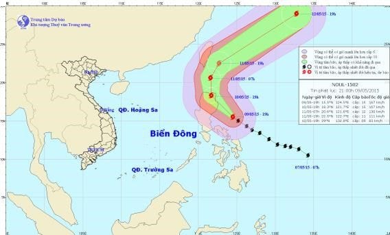 |
| Diagram showing the path of Typhoon Noul (image: National Center for Hydro-Meteorological Forecasting) |
Over the next 24 to 48 hours, the storm will continue to move in a north-northwest direction, then potentially change direction to the north-northeast, traveling at approximately 20 km per hour.
As of 7 PM on May 11th, the typhoon's center was located at approximately 22.5 degrees North latitude and 122.7 degrees East longitude, about 160km east-southeast of Taiwan (China). The strongest winds near the center of the typhoon reached level 12 (118 to 133 km per hour), with gusts of level 14 and 15.
Due to the influence of the storm's circulation, from the evening of May 10th, the northeastern part of the East Sea will experience strong winds of force 6-8, gusting to force 9-10. The sea will be rough.
Over the next 48 to 72 hours, the storm will move rapidly northeastward, traveling approximately 40 km per hour.
According to The Guardian, thousands of people have been evacuated from several dangerous areas in the Philippines ahead of a major storm, with winds reportedly exceeding 160 km/h, making landfall.
The northwestern region of Luzon Island (Philippines) is forecast to bear the brunt of this Category 4 typhoon when it makes landfall at 5:00 AM (local time) on May 10th.
Raben Dimaano, an official from the disaster relief agency in Sorsogon province, said that more than 11,000 people have been evacuated to temporary shelters in two towns around Mount Bulusan due to fears of landslides.
Within the next few hours, mayors of cities potentially affected by the storm will decide whether to continue evacuating residents. According to local weather forecasts, 19 locations on Luzon Island are believed to be within the storm's path.
The storm is forecast to make landfall in Cagayan and Isabela provinces in the Philippines before gradually weakening as it moves along the Sierra Madre mountain range and northeast of the island.
According to Infonet

