Storm news in the East Sea, storm number 1
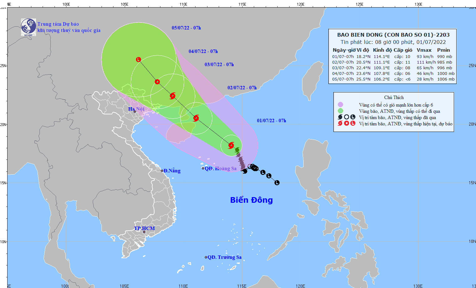
(Baonghean.vn) - At 7:00 a.m. on July 1, the center of the storm was at about 18.2 degrees North latitude; 114.1 degrees East longitude, about 400 km East Southeast of Hainan Island (China).
The strongest wind near the storm center is level 10 (89-102km/h).level 13.Radius of strong winds level 6, gusting to level 8 about 150km from the center of the storm.
Forecast for the next 24 hours, the storm is moving mainly in the Northwest direction, traveling about 15 km per hour and has the potential to strengthen. At 7:00 a.m. on July 2, the center of the storm was at about 20.5 degrees North latitude; 111.1 degrees East longitude, in the sea northeast of Hainan Island (China), about 370 km East Southeast of Quang Ninh. The strongest wind near the center of the storm is level 11 (103-117 km/hour).level 14.
 |
Internet photo. |
Dangerous areas due to storms in the East Sea in the next 24 hours(strong wind from level 6 or higher, gusts from level 8 or higher): North of latitude 16 degrees North; from longitude 108.5 to 116.0 degrees East. All vessels operating in the danger zone are at high risk of being affected by strong gusts of wind and large waves.Disaster risk level: level 3.
Over the next 24 to 48 hours,The storm is moving mainly in the northwest direction, traveling 10-15 km per hour. At 7:00 a.m. on July 3, the center of the storm was at about 22.4 degrees North latitude; 109.1 degrees East longitude, on the mainland southeast of Guangxi province (China), about 150 km east-northeast of Quang Ninh. The strongest wind near the center of the storm is level 8 (62-74 km/h).level 10.
Dangerous areas due to storms in the East Sea in the next 24 - 48 hours(strong wind from level 6 or higher, gusts from level 8 or higher): North of latitude 18.0 degrees North; from longitude 106.0 to 114.0 degrees East. All vessels operating in the danger zone are at high risk of being affected by strong gusts of wind and large waves.Disaster risk level: level 3.
Over the next 48 to 72 hours,The storm moved mainly in the northwest direction, traveling about 10 km per hour and weakened into a tropical depression. At 7:00 a.m. on July 4, the center of the tropical depression was at about 23.6 degrees North latitude; 107.8 degrees East longitude, about 210 km north of Quang Ninh. The strongest wind near the center of the tropical depression was level 6 (39-49 km/h).level 8 jerk.
During the next 72 to 96 hours,The tropical depression is moving northwest at 10-15 km per hour and is weakening.
Warning of strong winds, big waves at sea, high tides:Due to the influence of the storm circulation, the North East Sea area (including the Hoang Sa archipelago) has strong winds of level 8-9, near the storm center strong winds of level 10-11, gusts of level 14; waves from 5.0-7.0m high, rough seas. Coastal areas of provinces from Quang Ninh to Ninh Binh need to be on guard against big waves combined with high tides causing flooding in low-lying areas.
In the sea area from Binh Thuan to Ca Mau, the central and southern East Sea (including the sea area of Truong Sa archipelago), strong southwest wind level 6, sometimes level 7, gusting to level 8-9, waves from 2.0-4.0m high, rough sea.