Latest news on storm No. 4 - Podul: Forecast to make landfall from Thanh Hoa to Quang Binh
(Baonghean.vn) - According to forecasts, in the next 48 to 72 hours, storm Podul will move in the West Northwest direction, traveling 15-20km per hour, making landfall in the provinces from Thanh Hoa to Quang Binh, then weakening into a tropical depression.
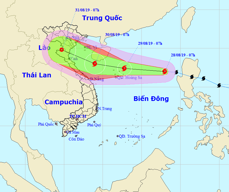 |
| The storm's path at 7 a.m. on August 28. Photo: North Central Hydrometeorological Station |
According to the North Central Hydrometeorological Station, at 7:00 a.m. on August 28, the center of the storm is located at about 17.0 degrees North latitude; 118.0 degrees East longitude, about 620km east of Hoang Sa archipelago. The strongest wind near the center of the storm is level 8 (60-75km/hour),level 10. Radius of strong winds level 6, gusting to level 8 or higher about 100km from the center of the storm.
Forecast for the next 24 hours,The storm is moving westward at about 30km per hour and is likely to strengthen. At 7am on August 29, the storm's center was at about 17.4 degrees North latitude; 112.8 degrees East longitude, right on the Hoang Sa archipelago. The strongest wind near the storm's center is level 8-9 (60-90km/hour).level 11.
Dangerous areas in the East Sea in the next 24 hours(strong wind level 6, gust level 8 or higher)): North of latitude 15.0 degrees North; East of longitude 110.5 degrees East.
Over the next 24 to 48 hours,The storm is moving mainly in the West-Northwest direction, traveling 15km per hour and is likely to strengthen. At 7:00 a.m. on August 30, the center of the storm was at about 18.0 degrees North latitude; 109.0 degrees East longitude, just south of Hainan Island. The strongest wind near the center of the storm is level 9-10 (75-100km/hour).level 12.
Over the next 48 to 72 hours,The storm moved in the West Northwest direction, traveling 15-20km per hour, entering the mainland provinces from Thanh Hoa to Quang Binh, then weakened into a tropical depression. At 7:00 a.m. on August 31, the center of the tropical depression was at about 19.8 degrees North latitude; 104.7 degrees East longitude, on the Vietnam-Laos border area. The strongest wind near the center of the tropical depression was level 6-7 (40-60km/hour).level 9.
Storm disaster risk level: level 3.