Latest news on Typhoon Sarika, which has gusts up to level 17.
(Baonghean.vn) - Typhoon Sarika, with gusts reaching level 17, is moving in a complex manner across the East Sea.
The Central Meteorological and Hydrological Forecasting Center stated thatAt 1:00 AM on October 16th,The typhoon's center is located at approximately 15.7 degrees North latitude and 121.8 degrees East longitude, right off the southeastern coast of Luzon Island (Philippines). The strongest winds are near the center of the typhoon.level 15(165-185 km/h)Shocks exceeding level 17.
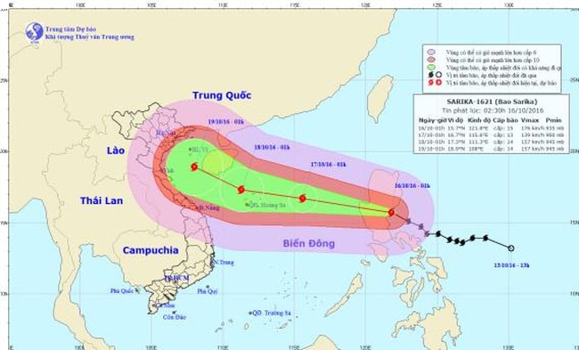 |
| The location and path of the storm. |
Forecast for the next 24 hoursThe storm is moving in a west-northwest direction, then likely to change direction to the west, traveling at approximately 20-25 km/h. Therefore, this morning (October 16th), the storm's center will enter the eastern part of the North East Sea. By 01:00 on October 17th, the storm's center will be located at approximately 16.7 degrees North latitude; 115.6 degrees East longitude, about 350 km east of the Hoang Sa (Paracel) Islands. The strongest winds near the storm's center will be at level 13 (135-150 km/h).level 16.
Hazardous area:Strong winds of force 6 or higher are expected north of 140°N latitude and east of 1130°E longitude. Strong winds of force 8 or higher are expected north of 150°N latitude and east of 1140°E longitude. Disaster risk level: level 3.
Over the next 24 to 48 hours,The storm is moving mainly westward, then likely to change direction to west-northwest, traveling at approximately 15-20 km per hour and potentially intensifying. By 01:00 on October 18th, the storm's center will be located at approximately 17.3 degrees North latitude; 111.3 degrees East longitude, in the sea northwest of the Hoang Sa archipelago. The strongest winds near the storm's center will reach level 14.level 17.
Due to the influence of the storm, the northern South China Sea area (including the waters around the Hoang Sa archipelago) will experience strong winds of force 8-12, with winds near the storm's center reaching force 13-14.level 17The sea was extremely rough.Level of natural disaster risk: level 3.
Over the next 48 to 72 hours,The storm is moving in a west-northwest direction at a speed of 15 km per hour.
The National Center for Hydro-Meteorological Forecasting warns that this is a strong storm, moving rapidly and with complex developments, requiring close monitoring in subsequent bulletins.
PV
| RELATED NEWS |
|---|

