On the rivers and streams in Nghe An area, there will be a flood with a flood amplitude of 2-5m.
(Baonghean.vn) - Due to the impact of storm No. 3, a flood will appear on rivers and streams in the Northern region and Thanh Hoa and Nghe An provinces with a flood amplitude of 2-5m. The peak flood level on Thao River is likely to reach alert level 2, the upstream of Lo River will reach level 1-2, the upstream of Thai Binh River will reach level 1; the main rivers in Thanh Hoa and Nghe An will be below alert level 1.
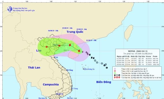
At 4:00 a.m. on August 1, the center of the storm is located at about 20.0 degrees North latitude; 110.8 degrees East longitude, in the area north of Hainan island, about 370km East Southeast of the mainland of Quang Ninh-Hai Phong provinces. The strongest wind near the center of the storm is level 9 (75-90km/h), gusting to level 12. The radius of strong winds of level 6, gusting to level 8 or higher is about 170km from the center of the storm.
Forecast for the next 24 hours, the storm is moving in the West Northwest direction, traveling 10-15km per hour, around this afternoon (August 1) the storm will enter the northern area of the Gulf of Tonkin and is likely to strengthen. At 4:00 a.m. on August 2, the center of the storm is at about 21.2 degrees North latitude; 108.9 degrees East longitude, in the sea area north of the Gulf of Tonkin, about 120km east of the coast of Quang Ninh-Hai Phong. The strongest wind near the center of the storm is level 9 (75-90km/hour), gusting to level 12.
 |
| PHOTO SERIES OF THE STORM'S PATH AND LOCATION |
In the next 24 to 48 hours, the storm moved mainly in the West direction, traveling 5-10km per hour, entering the mainland of the provinces from Quang Ninh to Nam Dinh and gradually weakening into a tropical depression. At 04:00 on August 3, the center of the tropical depression was at about 21.1 degrees North latitude; 106.7 degrees East longitude, on the mainland of the northeastern provinces. The strongest wind near the center of the tropical depression was level 6-7 (40-60km/h), gusting to level 10.
In the next 48 to 72 hours, the tropical depression changed direction to West Southwest, moving about 10km per hour, moving deep inland and gradually weakening into a low pressure area.
Due to the influence of the storm, in the western sea area of the North East Sea (including the sea area north of Hoang Sa archipelago), there will be stormy rain, strong winds of level 6-7, near the storm center of level 8-9, gusting to level 12; waves 3.0-5.5m high; very rough seas.
From this morning (August 1),In the Gulf of Tonkin (including the island districts of Bach Long Vi, Co To, Cat Hai, Van Don), the wind will gradually increase to level 6, from this afternoon and tonight it will increase to level 7-8, near the storm center it will be level 9, gusting to level 12. Waves will be 3-5m high. The sea will be very rough.
Strong wind warning on land:On land, coastal provinces from Quang Ninh to Nam Dinh from noon on August 2 will have strong winds of level 5, sometimes level 6; from afternoon on August 2, strong winds of level 6-7, near the storm's eye level 7-8, gusting to level 11.
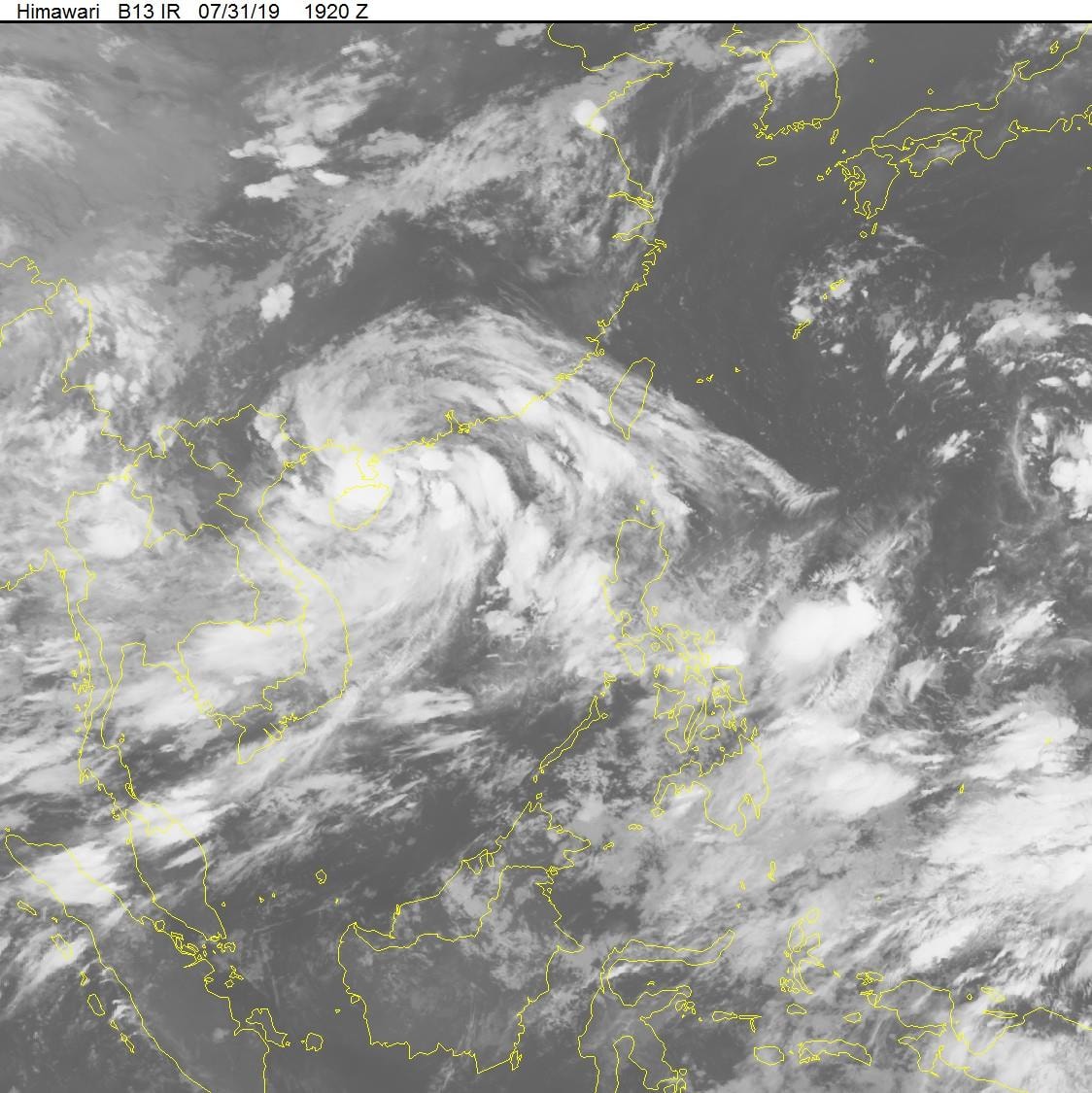 |
| SATELLITE CLOUD IMAGES |
Hanoi area: Rain, from August 2, there will be moderate rain, heavy rain and thunderstorms. Thunderstorms may have tornadoes, lightning and strong gusts of wind.
Flood, flash flood, landslide, inundation warning:On the rivers and streams in the Northern region and Thanh Hoa and Nghe An provinces, there will be a flood with a flood amplitude of 2-5m. The peak flood level on Thao River is likely to reach alert level 2, the upstream of Lo River will reach level 1-2, the upstream of Thai Binh River will reach level 1; the main rivers in Thanh Hoa and Nghe An will be below alert level 1.
High risk of flash floods and landslidesIn mountainous areas, flooding in low-lying areas of the Northern mountainous provinces, the North Central provinces; especially the provinces of Quang Ninh, Lang Son, Bac Kan, Cao Bang, Ha Giang, Yen Bai, Lao Cai, Hoa Binh, Son La, Lai Chau, Thanh Hoa, Nghe An.
Storm disaster risk level: level 3.