Application of GIS technology in management and protection of relics
The Hue Monuments Conservation Center has just successfully implemented and put into practice the project: Applying GIS technology to manage and protect monuments. With this project, the protection zone of monuments belonging to the Hue Monuments system managed by the center will be managed, protected, and controlled promptly when an incident occurs.
 |
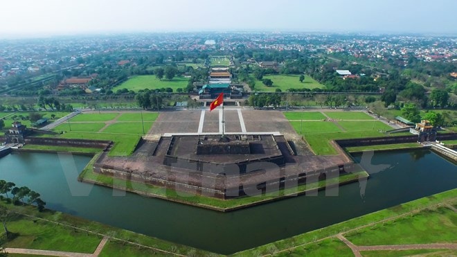
| Hue ancient capital seen from above - Photo: Vietnamplus |
To have a database for GIS technology, the Hue Monuments Conservation Center has organized a research team to collect and build map layers; collect information related to protected areas of monuments, such as: location, plot number, plot area, current housing status, residence time of households, number of households, population, population increase and decrease, illegal housing construction and factors polluting the monument environment; build an information lookup system on GIS; build a geographic information system to serve management agencies...
Ms. Le Thi An Hoa, Head of Scientific Research Department - Hue Monuments Conservation Center said: Previously, to know the issues related to households living in the protected area of the monument, the management agency had to go to the field to investigate, which took a lot of time. Based on the data of GIS technology, managers can grasp the situation of households living in the area in the most effective and timely way. From there, managers can come up with timely regulatory solutions, not to affect the landscape of the monument, and at the same time encourage people to be aware of protecting the surrounding landscape and environment, not to harm the architectural works.
In Thua Thien - Hue, due to historical characteristics, there is a very large number of residents living in the relic area, strongly affecting the environment of Hue relic sites, with a great risk of affecting the original master plan of the relics, narrowing the space of the relics. Many households living in the relic protection area are increasing in number due to the situation of separating households, getting married, expanding houses, polluting the environment and violating the Heritage Law...
Just counting the Hue citadel wall system with a total length of more than 10km, it is estimated that there are currently 2,800 households with more than 10,000 people living, concentrated in the Thuong Thanh - Eo Bau area. These households are located in inner-city wards such as Thuan Loc, Thuan Thanh, Thuan Hoa, Tay Loc, Phu Binh, Phu Thuan and Phu Hoa, all of whom are poor households, working as cyclo drivers, motorbike taxi drivers, small traders...
After applying GIS technology, the Hue Monuments Conservation Center can control the increase and decrease of households, construction density and control illegal construction, if any. The impacts from households living in the protected area of the monument that directly affect the works, environment, landscape, etc. are also promptly captured. This will be an advantage for the management agency to have a suitable population dispersal plan or to evacuate households in an objective order of priority./.
According to VNA


.jpg)


.jpg)
