Having just experienced extreme heat, Nghe An is now facing the risk of flooding.
(Baonghean.vn) - The National Center for Hydro-Meteorological Forecasting warns that the tropical depression is likely to strengthen into a storm. Nghe An will have heavy rain, scattered thunderstorms, and the possibility of flooding.
According to the National Center for Hydro-Meteorological Forecasting, at 1:00 a.m. on July 2, the center of the tropical depression was at about 18.2 degrees North latitude; 113.0 degrees East longitude, about 190km northeast of Hoang Sa archipelago. The strongest wind near the center of the tropical depression was level 6-7 (40-60km/h), gusting to level 9. The radius of strong winds of level 6, gusting to level 8 or higher was about 80km from the center of the tropical depression.
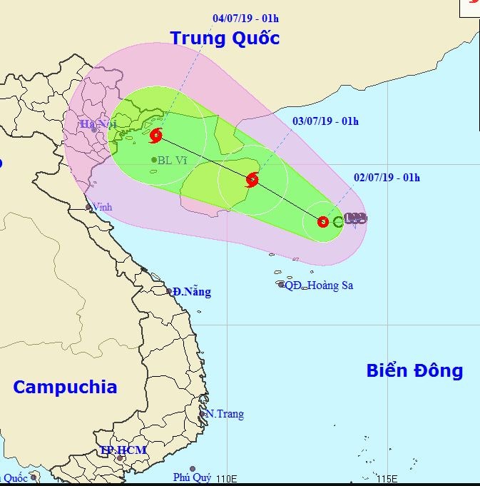 |
| Expected path and affected area of the tropical depression. Photo: nchmf.gov.vn |
It is forecasted that in the next 24 hours, the tropical depression will move in a West-Northwest direction, traveling about 10km per hour and is likely to strengthen into a storm. At 01:00 on July 3, the center of the storm will be at about 19.5 degrees North latitude; 110.8 degrees East longitude, right on the east coast of Hainan Island (China). The strongest wind near the center of the storm is level 8 (60-75km/h), gusting to level 11.
Due to the influence of the low pressure trough passing through the Northern region combined with the western edge of the tropical depression, today (July 2), in the Northern region and the provinces from Thanh Hoa to Thua Thien Hue there will be rain, especially in the Southern region of the Northern Delta and the provinces of Thanh Hoa, Nghe An, Ha Tinh, Quang Binh there will be moderate rain, heavy rain, some places will have very heavy rain and scattered thunderstorms (common rainfall 30-70mm/12 hours, some places over 100mm/12 hours). In thunderstorms there is a possibility of tornadoes, lightning and strong gusts of wind.
From tonight to July 4, due to the influence of a tropical depression that is likely to strengthen into a storm and move towards the mainland, in the provinces of Hoa Binh, Son La, the Northern Delta and North Central Coast, there will be very heavy rain (common rainfall 100-250mm/period, some places over 300mm/period); on July 3-4, the mountainous areas of the North will have moderate rain, heavy rain, some places very heavy rain (common rainfall 50-150mm/period, some places over 200mm/period); from tonight to July 3, the provinces from Quang Binh to Quang Nam will have moderate rain, heavy rain (common rainfall 50-100mm/period).
 |
| Since the afternoon of July 1, many localities in Nghe An have had moderate rain. Photo: Ngoc Phuong |
The National Center for Hydro-Meteorological Forecasting warns:On the rivers and streams in the Northern region, from Thanh Hoa to Ha Tinh, there will be a flood with a flood amplitude of 2-5m. The peak flood level on Thao River is likely to reach BĐ1, while rivers from Thanh Hoa to Ha Tinh are still below BĐ1.
After a long period of hot weather, the soil has dried and cracked, the soil properties have been broken and forest fires have occurred in the North Central region, the surface cover has been reduced, heavy rains over a large area have caused a high risk of flash floods, floods due to blocked waterways, mudflows, landslides in mountainous areas, and flooding in low-lying areas in the northern mountainous provinces, from Thanh Hoa to Quang Binh.
Especially the provinces of Lai Chau, Hoa Binh, Lao Cai, Yen Bai, Ha Giang, Tuyen Quang, Thanh Hoa, Nghe An, Ha Tinh, Quang Binh.
Nghe An has just experienced a month-long heat wave. There was no rain, the high temperature caused streams and dams to dry up. People's lives were disrupted; a series of forest fires broke out everywhere.