Low pressure area in the East Sea is likely to strengthen into a tropical depression.
(Baonghean.vn) - Due to the influence of the low pressure area, during the day and tonight (August 9), in the North and Central East Sea (including the waters of Hoang Sa archipelago), there will be showers and thunderstorms with strong gusts of level 8.
According to the National Center for Hydro-Meteorological Forecasting, at 1:00 a.m. on August 9, the center of the low pressure area was at about 15.7-16.7 degrees North latitude; 112.7-113.7 degrees East longitude, right on the sea southeast of Hoang Sa archipelago.
It is forecasted that in the next 24 hours, the low pressure area will move northwest, traveling 10-15km per hour and is likely to strengthen. At 1:00 a.m. on August 10, the center of the low pressure area will be at about 18.0-19.0 degrees North latitude; 111.0-112.0 degrees East longitude, about 100km southeast of Hainan Island (China). In the next 24 to 48 hours, the low pressure area will move north, traveling 5-10km per hour and is likely to strengthen into a tropical depression.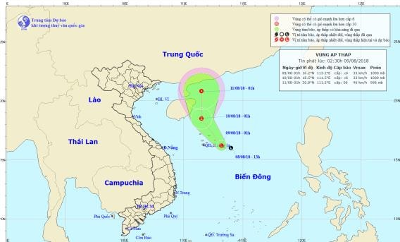 |
| Path and location of the low pressure area. Photo: National Center for Hydro-Meteorological Forecasting |
In addition, due to the influence of the tropical convergence zone combined with the strong southwest monsoon, during today and tonight, in the central and southern East Sea (including the sea area of Truong Sa archipelago), the sea area from Binh Thuan to Ca Mau will have strong southwest winds of level 6, gusting to level 8, waves from 2-4m high; rough seas.
The South China Sea (including the Truong Sa archipelago), the sea areas from Binh Thuan to Ca Mau, Ca Mau to Kien Giang and the Gulf of Thailand will have heavy thunderstorms; during thunderstorms, there is a possibility of tornadoes and strong gusts of wind. Disaster risk level due to strong winds and large waves: level 1.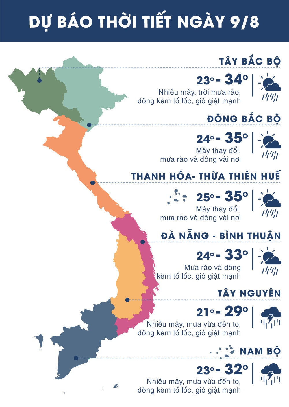 |
| Temperature on August 9 in regions across the country. Photo: news.zing.vn |
WARNING OF FLASH FLOODS, LANDSLAMS, LOCAL FLOODING IN GIA LAI AND KON TUM
In the past 3-4 hours, some places in Gia Lai and Kon Tum provinces have had heavy to very heavy rain. Rainfall at some stations is as follows: Ia Grai 3 hydropower plant 69.4mm, Ia Toi 56.4mm, Ia Dom 50.8mm, Hoa Binh 56.0mm, Ro Koi 57.2mm.
In the next 1-2 hours, these areas will continue to have moderate to heavy rain, with very heavy rain in some places.
Warning:In the next 3-6 hours, there is a high risk of flash floods, landslides on small rivers and streams in mountainous areas and localized flooding in low-lying areas in Gia Lai and Kon Tum provinces, especially in Ia Grai districts (Gia Lai) and Ngoc Hoi, Dak To, Sa Thay, Dak Ha, Tu Mo Rong, Ia H'Drai, Kon Tum city (Kon Tum).Disaster risk level: Level 1
