Tropical depression appears with the potential to strengthen into a storm in the East Sea
(Baonghean.vn) - Due to the influence of a tropical depression, which later strengthened into a storm, the Northeastern sea area of the North East Sea had heavy thunderstorms, strong winds of level 6-7, later increasing to level 8, gusting to level 11; rough seas.
In addition, very strong storm MANGKHUT in the Northwest Pacific Ocean may reach super typhoon level and move towards the North East Sea in the next 4-5 days.
According to the National Center for Hydro-Meteorological Forecasting, last night (September 10),The tropical depression has crossed the southern area of Taiwan and entered the northeastern waters of the South China Sea.
1:00 a.m. September 11, the center of the tropical depression is located at about21.2 degrees North Latitude; 119.7 degrees East Longitude, about 180km southwest of Taiwan. The strongest wind near the center of the tropical depression is level 7 (50-60km/hour),level 10. The range of strong winds of level 6, gusting to level 8 or higher is about 80km from the center of the tropical depression.
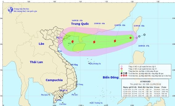 |
| The path and location of the tropical depression. Photo: National Center for Hydro-Meteorological Forecasting |
Forecast for the next 24 hours,The tropical depression is moving west-southwest at 10-15km per hour and is likely to strengthen into a storm. At 1am on September 12, the storm center was at about 20.6 degrees north latitude; 116.7 degrees east longitude, about 340km southeast of Hong Kong (China). The strongest wind near the storm center is level 8 (60-75km/hour).level 11The range of strong winds of level 6, gusting to level 8 or higher is about 100km from the center of the storm.
Due to the influence of a tropical depression, which later strengthened into a storm, the Northeast sea area in the North East Sea had heavy thunderstorms, strong winds of level 6-7, later increasing to level 8, gusting to level 11; rough seas.Disaster risk level due to tropical depression/storm: level 3.
Over the next 24 to 48 hours,The storm is moving west at 15-20km per hour and is likely to strengthen. At 1am on September 13, the center of the storm was at about 20.4 degrees North latitude; 112.7 degrees East longitude, about 230km east of Leizhou Peninsula (China). The strongest wind near the storm is level 8-9 (60-90km/hour).level 12. The range of strong winds of level 6, gusting to level 8 or higher is about 150km from the center of the storm.Disaster risk level: level 3.
During the next 48 to 72 hours,The storm moved west at 15-20km per hour.
 |
| Temperature on September 11 in regions across the country. Photo: news.zing.vn |