A low pressure area appears that is likely to strengthen into a tropical depression.
(Baonghean.vn) - Early this morning (June 1), on the low pressure trough with an axis at about 7-10 degrees North latitude, a low pressure area was formed at 1:00 a.m. at about 8.5-9.5 degrees North latitude; 117.5-118.5 degrees East longitude.
Forecast for the next 24 hoursThis low pressure area is likely to move in a West Northwest direction, traveling 5-10km per hour and is likely to strengthen into a tropical depression.
Due to the influence of the low pressure area that is likely to strengthen into a tropical depression, in the next 1-2 days in the Central and Southern East Sea (including the waters of Truong Sa archipelago), there will be strong thunderstorms; strong winds of level 5, later increasing to level 6, gusting to level 8; rough seas.Disaster risk level: level 1.
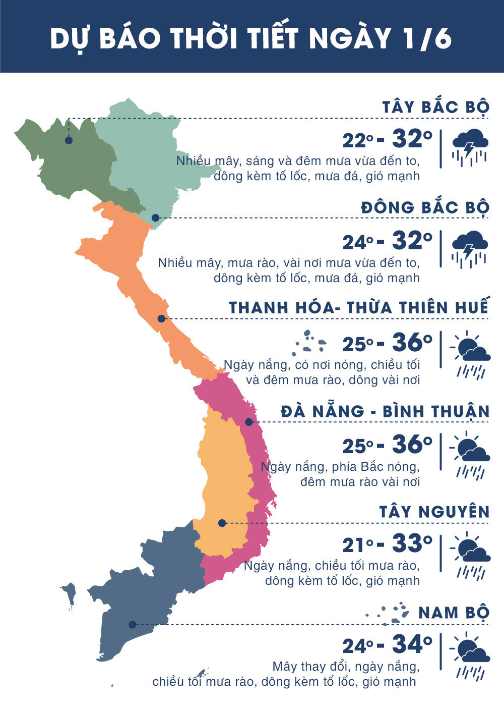 |
| Temperature on June 1, 2018 in regions across the country. Source: Zing.vn |
WARNING:
1. Heavy rain in the Northern mountainous region
Currently (June 1)): The low pressure trough with its axis at about 23-25 degrees North latitude is continuing to be compressed by continental high pressure from the North.
Forecast: Due to the impact of the compressed low pressure trough analyzed above, from tonight (June 1) to the end of the night of June 2, there will be showers and thunderstorms in many places in the North, the mountainous and midland provinces of the North will have moderate rain, some places will have heavy rain and thunderstorms; the heavy rain will be concentrated at night and early morning. During the thunderstorms, there is a high possibility of tornadoes, hail and strong gusts of wind. Disaster risk level: level 1.
2. Widespread thunderstorms in the Central Highlands and the South
Early this morning (June 1), on the low pressure trough with an axis at about 7-10 degrees North latitude, a low pressure area was formed, located at 1:00 a.m. at about 8.5-9.5 degrees North latitude; 117.5-118.5 degrees East longitude.Forecast: Due to the influence of low pressure from today (June 1), in the Central Highlands and the South, there will be showers and thunderstorms in many places. In the Southern Central Highlands and the Southern provinces, there will be moderate rain, heavy rain and thunderstorms in some places.
From June 2, the southwest monsoon appeared and became stronger, so the Central Highlands and the South had moderate to heavy rain, which could last for many days. Disaster risk level: level 1.