Affected by storm No. 1, from the night of July 17 to July 20, Nghe An will have heavy to very heavy rain.
(Baonghean.vn) - According to the forecast from the North Central Hydrometeorological Station, tonight and tomorrow, storm No. 1 will enter the Gulf of Tonkin. Affected by storm No. 1, from the night of July 17 to July 20, Nghe An will have heavy to very heavy rain.
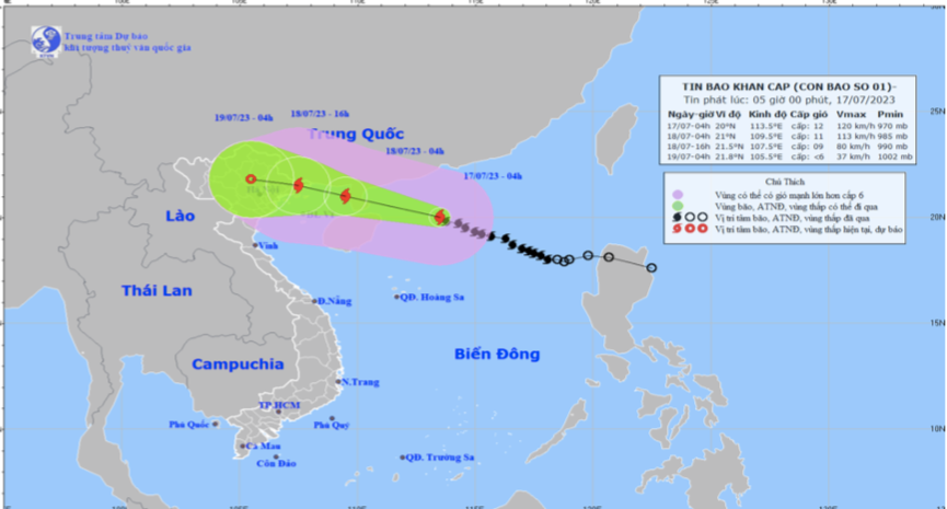
URGENT STORM NEWS (STORM NO. 1)
At 4:00 a.m. on July 17, the center of the storm was at about 20.0 degrees North latitude; 113.5 degrees East longitude, about 340km East Southeast of Leizhou Peninsula (China). The strongest wind near the center of the storm was level 11-12 (103-133km/h), gusting to level 15.
Storm forecast (in the next 24 to 72 hours):
| Forecast time | Direction, speed | Location | Intensity | Danger zone | Disaster risk level (Affected area) enjoy) |
| 04h/18/7 | West Northwest, 15-20 km/h. Storm is likely to be strong more | 21.0N-109.5E; in the western area of Leizhou peninsula (China), about 190km East Southeast of Mong Cai (Quang Ninh), about 100km from Hai Phong 290km to the East | level 11-12, jerk level 15 | North of latitude 17.5N; 107.5E-115.5E | Level 3: North of the North East Sea area, North Gulf of Tonkin |
| 16h/18/7 | West Northwest, 15-20 km/h and weakening gradually | 21.5N-107.5E; on the sea of Quang Ninh-Hai Phong provinces | level 9, jerk level 12 | North of the 18th parallel N; West of the meridian 112.0E | Level 3: Northern Gulf of Tonkin, northeastern coastal areas Set |
| 04h/19/7 | West Northwest, 15-20 km/h and weakening gradually become a low pressure area | 21.8N-105.6E; on land in the Northeast region of the North | < level 6 | North of latitude 18.0N; West of longitude route 111.5E | Level 3: Northern Gulf of Tonkin, Northeast region |
Forecast of storm impact:
- The northern sea area of the North East Sea has strong winds of level 8-9, near the storm center strong winds of level 10-11, then increasing to level 12, gusting to level 15. The sea is very rough.
- From around the afternoon of July 17, the northern Gulf of Tonkin (including Bach Long Vy and Co To island districts) will have winds gradually increasing to level 6-7, then increasing to level 8-9, near the storm center level 10-11, gusting to level 14. The sea will be very rough.
- From early morning on July 18, coastal areas from Quang Ninh to Nam Dinh have winds gradually increasing to level 6-7, then increasing to level 8, areas near the storm center have winds of level 9-10, gusting to level 13; areas deep inland in the Northeast have strong winds of level 6-7, gusting to level 9.
- The sea area north of the North East Sea has waves 5.0-7.0m high.
- From the morning of July 18, the sea in the North Gulf of Tonkin has gradually increasing waves, 3.0-5.0m high. In the coastal areas of Quang Ninh - Nam Dinh provinces, the waves are 2.0-4.0m high. Storm surge, risk of flooding in coastal areas:
- Coastal areas of Quang Ninh-Thai Binh provinces have storm surges of 0.5-0.8m.
- High risk of flooding in low-lying areas in coastal areas, river mouths, and coastal erosion due to the combined impact of high tides on the afternoon of July 18.
- From the night of July 17 to July 20, in Thanh Hoa area, there will be moderate rain, heavy rain, and very heavy rain in some places with common rainfall of 100-200mm, locally over 300mm. Nghe An province will have moderate rain, heavy rain, and very heavy rain in some places and thunderstorms with forecasted common rainfall of 60-120mm, and in some places over 150mm. Ha Tinh will have showers and thunderstorms, locally moderate to heavy rain in some places.
- Beware of the risk of thunderstorms, tornadoes and strong gusts of wind in the storm's circulation area, both before and during the storm's landfall.
FORECASTWEATHER ON LAND IN NGHE AN PROVINCE ON JULY 17, 2023
* Coastal plain area
Clouds change to cloudy, sunny during the day, hot in some places. Rain, scattered showers and thunderstorms in the afternoon and at night. North to northwest wind level 3, gradually increasing to level 4-5 at night, level 6 in some places, gusting to level 7.
- Temperature: 26 - 35oC.
- Humidity: 80 - 90%
* Midland and mountainous areas.
- Partly cloudy to hot during the day. Scattered showers and thunderstorms in the afternoon and evening. Light winds.
- Temperature: 24 - 36oC, some places higher than 37oC.
- Humidity: 80 – 90%
* Vinh City Area
- Cloudy to mostly cloudy, hot during the day, occasional showers and thunderstorms in the afternoon and at night. North to northwest wind level 3, gradually increasing to level 4-5 at night.
- Temperature: 26 - 35oC.
- Humidity: 80 - 85%
* Cua Lo and Ngu Island area
- Cloudy to mostly cloudy, sunny during the day. Showers and thunderstorms at times in the afternoon and at night. North to northwest wind level 3, increasing to level 4-5 at night.
- Temperature: 26 - 34oC.
- Humidity: 85 - 90%
*Next 48 hours:Affected by the circulation of storm No. 1 (international name: TaLim), Nghe An province has cloudy weather with scattered rain, moderate to heavy rain, some places have very heavy rain and thunderstorms. Strong winds level 3, coastal areas level 4-5, some places level 6, gusting to level 7.
* During thunderstorms there is a possibility of tornadoes, lightning, hail and strong gusts of wind.


