Tropical depression heading to the Gulf of Tonkin, Nghe An is about to have heavy rain
The low pressure area in the East Sea has strengthened into a tropical depression, about 300 km from Hoang Sa archipelago (Vietnam) on the afternoon of July 30 with wind speeds of 50 km/h.
The National Center for Hydro-Meteorological Forecasting said that tonight and tomorrow the tropical depression will move west-northwest, at a speed of 15-20 km per hour and is likely to strengthen. By 1 pm tomorrow, July 31, the center of the depression will be 100 km east of Hainan Island (China), with the strongest wind speed increasing to 60 km/h, level 7.
Tomorrow night, the tropical depression will strengthen into a storm. At a speed of 15 km/h, moving in the West Northwest direction, by the morning of August 1, the storm will pass Hainan Island (China) into the Gulf of Tonkin, causing strong winds of level 8-9, said Mr. Tran Quang Nang, Head of the Weather Forecast Department (National Center for Hydro-Meteorological Forecasting)..
|
Forecast of the path and affected area of the tropical depression on the afternoon of July 30. Source:NCHMF. |
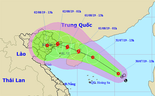
According to Mr. Nang, from the night of August 1 to the morning of August 2, the storm will make landfall in the provinces from Quang Ninh to Nam Dinh with strong winds of level 7-8 and cause heavy rain in the North and North Central regions from the afternoon of August 1 to August 4.
The meteorological agency warned that the tropical depression formed right in the East Sea, with the interaction and influence of continental atmospheric systems as well as the southwest monsoon system, will have complicated developments.
Formed from onelow pressure areain the East Sea this morning, if it strengthens into a storm, this will be the third storm this year. The first storm in early January was from 2018, the second storm entered Quang Ninh - Hai Phong on July 4, causing rain in the North and North Central regions, killing 2 people.
It is forecasted that this year the East Sea will have about 9-11 storms and tropical depressions, of which 3-4 will directly affect the mainland.
Many mountainous provinces are at risk of flash floods and landslides.
Due to the influence of low pressure trough combined with wind convergence above 1,500 m, from the night of July 29 to July 31, the North will have showers and thunderstorms, and heavy rain in mountainous areas. In particular, the provinces of Lai Chau, Dien Bien, Lao Cai, Yen Bai, Ha Giang, and Tuyen Quang will have rain of 20-50 mm/12 hours, and in some places over 70 mm/12 hours. Due to heavy rain, flash floods and landslides are at risk.
Previously, on July 28-29, Ha Giang province experienced heavy rain, with some areas experiencing over 100 mm. Landslides occurred in Hoang Su Phi district, killing 2 people and injuring 3 others; Provincial Road 177 Bac Quang - Hoang Su Phi and Road 178 from km40 to km55 were affected by landslides.
