Low pressure in the East Sea may strengthen into a storm, North Central region has heavy rain
(Baonghean.vn) - According to the National Center for Hydro-Meteorological Forecasting, early this morning, the strongest wind near the center of the tropical depression was level 7 (50-60km/hour), gusting to level 9. The range of strong winds of level 6, gusting to level 8 was about 70km from the center of the tropical depression.
At 1:00 a.m. on August 13, the center of the tropical depression is located at about 20.6 degrees North latitude; 112.6 degrees East longitude, right on the sea south of Guangdong province (China).
Forecast for the next 24 hours, the tropical depression is moving in the East Southeast direction, then is likely to change direction to the West Northwest at about 5km per hour and strengthen into a storm.
At 1:00 a.m. on August 14, the center of the storm was located at about 20.7 degrees North latitude; 113.1 degrees East longitude, in the sea south of Guangdong province (China). The strongest wind near the center of the storm was level 8 (60-75 km/h), gusting to level 10. The range of strong winds of level 6, gusting to level 8 was about 100 km from the center of the storm.
Dangerous areas in the East Sea in the next 24 hours (strong wind level 6 or higher): North of latitude 19.0 degrees North; East of longitude 110.5 degrees East.
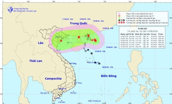 |
| Path and location of the tropical depression. Photo: National Center for Hydro-Meteorological Forecasting |
Over the next 24 to 48 hours,The storm is moving northwest at about 5km per hour. At 1am on August 15, the center of the storm was at about 21.5 degrees North latitude; 111.9 degrees East longitude, in the sea south of Guangdong province (China). The strongest wind near the center of the storm is level 8 (60-75km/h), gusting to level 10. The range of strong winds of level 6, gusting to level 8 is about 100km from the center of the storm.
In the next 48 to 72 hours, the storm will move west at about 10km per hour. Disaster risk level due to tropical depression: level 3.
Heavy rain warning:On August 14-15, there will be scattered rain in the North. From the night of August 15 to August 17, there will be heavy to very heavy rain in the Northern and North Central provinces (rainfall 250-350mm/period).
In addition, due to the influence of the tropical convergence zone combined with the strong southwest monsoon, during the night of August 12 and today, in the Central and Southern East Sea (including the waters of Truong Sa archipelago), the sea area from Binh Thuan to Ca Mau continues to have strong southwest winds of level 6, gusting to level 8, waves from 2-4m high; rough seas.
The Gulf of Tonkin, the sea areas from Binh Thuan to Ca Mau, Ca Mau to Kien Giang and the Gulf of Thailand will have heavy thunderstorms; during thunderstorms there is a possibility of tornadoes and strong gusts of wind. Disaster risk level due to strong winds and large waves: level 1.
WARNING OF FLASH FLOODS, LANDSCAPES, LOCAL FLOODING IN QUANG TRI
In the past 3-4 hours, some places in Quang Tri province have had heavy to very heavy rain. Rainfall at some stations is as follows: Tan Long 34.2mm, Huong Phung 62.4mm, Quang Tri hydropower 77.8mm.
In the next 1-3 hours, this area will continue to have moderate to heavy rain, with very heavy rain in some places.
Warning:In the next 3-6 hours, there is a risk of flash floods, landslides on small rivers and streams in mountainous areas and localized flooding in low-lying areas in Quang Tri province, especially Huong Hoa district. Disaster risk level: Level 1.


.jpeg "Công ty TNHH MTV Lâm Nông nghiệp Sông Hiếu thiệt hại lớn sau mưa bão")
