The world's oldest map, dating back 5,000 years.
Danish archaeologists have discovered a stone with strange carvings believed to be the world's oldest map, dating back 5,000 years.
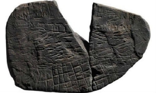 |
| The two pieces of the stone are believed to be the remains of one of the world's oldest maps. Photo: Skalk. |
Researchers at the National Museum of Denmark discovered numerous artifacts and a stone inscribed with symbols believed to be the world's oldest map on the Danish island of Bornholm in the Baltic Sea, Science Alert reported on November 10.
The stone, approximately 5 cm wide, dates from between 2900 and 2700 BC. It broke into three smaller pieces when Stone Age farmers performed a ritual of sun worship. Archaeologists have only found two pieces of the stone so far; the third piece is missing.
"These aren't random scratches. Some of the lines could be drawings of cornfields, trees, and roads. If the stone really is a map, it would be one of a kind," said Fleming Kaul, a member of the research team.
According to Kaul, the stone is not a map in the modern sense, but rather a stylized map. He suggests that the intricate drawings on the stone depict the detailed topography of Bornholm Island nearly 5,000 years ago.
"I can see some similarities with rock carvings in the Alps, northern Italy, from the same period. Accordingly, the rock drawings were interpreted as symbolic landscapes, similar to what we have just unearthed," Kaul said.
Previously, stones carved with images of the sun and sunbeams were also found on Bornholm Island. Archaeologists believe they were used in rituals to pray for fertile land.
According to VNE

