Evidence affirming Vietnam's sovereignty over Hoang Sa - Truong Sa
The largest exhibition ever affirming Vietnam's sovereignty over the Hoang Sa and Truong Sa archipelagos opened on the morning of July 9 at the Vietnam Military History Museum in Hanoi.
The exhibition was organized by the Ministry of Information and Communications in coordination with many departments and localities, and was collected and prepared over the past 6 months. The 200 documents, books, artifacts and ancient maps on display are a clear, objective and convincing affirmation of Vietnam's sovereignty over Hoang Sa and Truong Sa.
"The sea border of our country includes the very dangerous Hoang Sa region... Every year, people should be sent to survey everywhere to know the sea route..." (National History Institute of the Nguyen Dynasty, Dai Nam Thuc Luc Chinh Bien, 1836). One of the 19 Nguyen Dynasty documents is the most important part of the exhibition, affirming the legality and State ownership of Vietnam over Hoang Sa and Truong Sa, which is being widely announced to the public for the first time.
Mr. Le Van Nghiem, Director of the Department of Foreign Information, Ministry of Information and Communications, Head of the exhibition organizing committee said: “No other country has these documents, they show that Vietnam has exercised the State's rights over Hoang Sa - Truong Sa for hundreds of years, and in peace, without anyone claiming any dispute. The disputes have only really appeared in the last 100 years...”.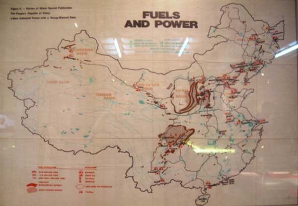
A map of fuel and energy resources published in the US in 1975 showed China's southernmost territory only reaching Hainan Island.
The 200 exhibits, books, documents, and maps on display are complementary, logical, and consistent with each other. Ancient maps and books from Vietnam, the West, and China itself all confirm that China's southern border only extends to Hainan Island, and that Hoang Sa and Truong Sa belong to Vietnam's waters.
According to Professor Phan Huy Le, Chairman of the Vietnam Historical Science Association: “In these maps, China itself has never acknowledged that Hoang Sa - Truong Sa are in their waters. They all deny their current arguments...”.
34 exhibition panels, arranged by content, with clear translations and annotations in Vietnamese and English, help viewers have a clear and systematic view: Vietnam map from the 16th-19th centuries, Western maps of China and Vietnam, China's own maps, documents from the Nguyen Dynasty and the period before 1975, current images of Truong Sa...
Dr. Mai Hong, who donated the map “Hoang Trieu Truc Tinh Dia Du Toan Do” shared: “I am very happy! Anyone who loves the sea and islands of the Fatherland will be happy to see an exhibition like this.”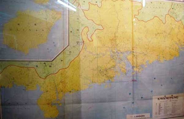
Map of Guangdong province (republished by China in 1933) shows the southernmost part of China only reaching Hainan Island. Photo: NLĐ
Mr. Do Quy Doan, Deputy Minister of Information and Communications, Head of the Exhibition Steering Committee emphasized: "The clear message to the people of the world and China is that the Vietnamese people have always affirmed and preserved their sovereignty, in the spirit of peace and respect for international law."
The Vietnamese people and the world need to know these historical documents, which are a strong affirmation of Vietnam's sovereignty over the sea of our ancestors.
The exhibition is scheduled to run until July 15.
According to VTV - TH


