Record frost in nearly 120 years in Washington DC
At least 29 people have died, thousands of flights have been canceled or delayed and tens of thousands of households are without power.
That is the immediate consequence of the record-breaking ice that has been affecting many states in the US for nearly a week now.
After sweeping through the Southern and Midwestern states since the night of February 16 (local time), a new snowstorm has begun to attack the states in the Northeastern region of the United States.
The path of this blizzard is 3,200km long, from southern Missouri in the Midwest to Maine in the Northeast.
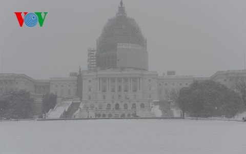 |
| Snow covers the US Capitol building |
From noon on February 21, heavy snow began to fall in the Washington DC area and Baltimore city in Maryland, followed by New York City and Boston city in Massachusetts later in the day.
Meteorologist Bob Oravec said that Boston has had to endure more than 250cm of snow since the beginning of winter and will have to witness even thicker snow in the coming days.
Icy weather conditions have been blamed for numerous road accidents. According to FlightAware.com, as of 9:30 p.m. on February 21, more than 1,500 flights had been canceled, more than 2,750 delayed, and many of those occurred at the two international airports in Washington, D.C., and Baltimore. 370 flights on February 22 were also officially canceled.
In Tennessee, 50,000 customers in 12 counties are living in frigid conditions without power. According to the Tennessee Emergency Management Agency, a total of 18 people have died in weather-related incidents so far, including nine from hypothermia and five from traffic accidents.
Kentucky has also recorded 10 weather-related deaths, and Pennsylvania has recorded two.
Although the snow only really started falling heavily at noon on February 21, the Northeastern United States has been experiencing record cold for the past few days.
In the Brooklyn borough of New York City, the average temperature on February 20 was -15.6 degrees Celsius, the lowest since 1950.
Notably, the 119-year-old record low temperature in Washington was broken on February 20, with the weather station at Ronald Reagan National Airport measuring an average temperature of minus 15 degrees Celsius and down to minus 19 degrees Celsius at night.
The record low temperatures of the past few days combined with this snowstorm have caused the famous Potomac River, along with other rivers and lakes in the Washington DC area, to freeze. According to the reporter's observation, by the afternoon of February 21, many people were walking and playing happily on the frozen lake in front of the US Capitol building.
Mike, a tourist from Italy, said: “For me, this kind of weather is not unusual. I am used to snow. The weather is beautiful and the time is also ideal for walking. I think it is great. I love Washington DC so when I come here I have to walk around to see this city.”
The National Weather Service predicts that another wave of arctic air will follow this blizzard, causing millions of people along the East Coast of the United States to endure sub-freezing temperatures on February 23.
According to vov.vn


