Level 10 storm heading towards Quang Ninh - Hai Phong
Vicente - the fourth storm active in the East Sea - is getting stronger, expected to make landfall in the Quang Ninh - Hai Phong sea area in the early morning of July 25. Hanoi and Hai Phong have been directed to prepare flood prevention plans.
>>Urgently deal with storm number 4
On the morning of July 23, the Central Steering Committee for Flood and Storm Prevention held a meeting to respond to storm Vicente. According to Director of the Central Hydrometeorological Forecasting Center Bui Minh Tang, this morning, the storm's center was about 390 km northeast of Hoang Sa archipelago with the strongest winds reaching level 9-10. Today and tonight, the storm will move in a west-northwest and northwest direction at a speed of 10-15 km per hour and is likely to strengthen.
Satellite cloud image of storm Vicente on the morning of July 23. Photo: NEA.
On the morning of July 24, the storm's eye was about 150 km east of Leizhou Peninsula (China) with the strongest winds reaching level 10, possibly reaching level 11. At noon the same day, the storm crossed Leizhou Peninsula, heading towards the coast of the northeastern provinces. By the evening of July 24, the storm approached the sea of Quang Ninh province, the eye of the storm was close to Mong Cai.
According to Mr. Tang, the storm will make landfall on the morning of July 25, then quickly weaken into a tropical depression and then a low-pressure area. The areas directly affected are Quang Ninh and Hai Phong. The coastal provinces from Thanh Hoa onwards are in the storm's circulation area.
The Director of the Center for Meteorological Forecasting said that the rain caused by the storm will last for about 2 days (from the afternoon of July 24 to the noon of July 26) with a total rainfall of 100-300 mm, some places up to 400 mm. Thus, combined with the rainfall yesterday and today, many places will have a total rainfall of up to 500-600 mm. The rain is concentrated in the Northeast, Viet Bac, and Northwest regions. According to Mr. Tang, since its formation, the storm has been constantly changing its direction of movement. Therefore, it is necessary to continue to closely monitor the developments.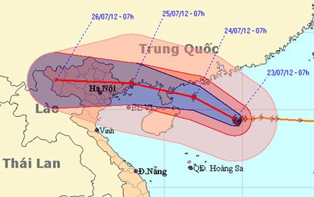
The storm is expected to sweep across the Leizhou Peninsula and make landfall in the Vietnam-China border area. Photo: NCHMF.
Reiterating the meteorological agency's warning, Minister of Agriculture Cao Duc Phat reminded that the storm's developments have changed, meaning that it could change further. Noting that the Quang Ninh - Hai Phong sea area has a lot of aquaculture, Mr. Phat asked the provinces to guide fishermen to return to shore tomorrow. In particular, he asked these two localities to issue sea bans depending on the situation, and not to ignore the storm warning because they have registered for a tour because the lesson from many years ago was that fishing boats did not sink but tourist boats anchored at the port sank.
According to Mr. Phat, in addition to prevention at sea, there are also many worrying things on land such as landslides at coal dumps causing deaths, high tides combined with rising sea levels... "Rain is forecast to be concentrated in mountainous areas, with a high risk of flash floods and landslides, so an evacuation plan is needed tomorrow," Mr. Phat emphasized.
Directing the meeting, Deputy Prime Minister Hoang Trung Hai emphasized the need to be especially vigilant against rain and storms, and not let them disrupt traffic. Mr. Hai requested that cities such as Hanoi and Hai Phong prepare plans to prevent flooding.
To respond to the storm's landing area, Mr. Hai requested that two working groups be sent to Quang Ninh and Hai Phong. The groups need to arrive early before the storm hits to check the rafts for people, boats, and anchors, and to secure houses...
Deputy Prime Minister Hoang Trung Hai directed two working delegations to go to Quang Ninh and Hai Phong early to respond to the storm. Photo: Nguyen Hung.
For ships at sea, the Deputy Prime Minister directed to call on ships to head south to avoid the storm. "Each rescue mission is costly, but the main thing is the danger to the rescuers. Therefore, it is best to forecast and notify early to call on ships to come ashore soon," said the Deputy Prime Minister.
To cope with storm Vicente, the Steering Committee for Flood and Storm Prevention has sent a telegram to localities. According to the Head of the Steering Committee's Office, Vu Van Tu, Quang Ninh province has banned fishing boats from going to sea since July 22. Currently, Quang Ninh and Hai Phong are monitoring further to ban tourist boats in the Gulf of Tonkin and protect coastal vehicles. In addition, all provinces from Quang Ninh to Phu Yen have been directed to monitor the activities of boats.
According to the Border Guard Command, as of 6:30 a.m. on July 23, provincial border guards had coordinated with local authorities, families of ship owners, captains and other forces to inform and guide 48,184 ships and 186,060 workers operating at sea to know the location and direction of the storm so that they could proactively avoid and escape from dangerous areas. Of these, 165 ships (1,648 workers) were operating in the Hoang Sa archipelago; 8,239 ships and rafts (40,236 workers) were operating in the Gulf of Tonkin and the open seas of Quang Ninh and Hai Phong. There have been no losses of ships or boats.
According to (VnExpress.net)-LT


