Level 15 storm heading towards the East Sea
The storm, internationally named Goni with winds of up to 185 km/h, is moving off the coast of the Philippines and towards the East Sea.
The National Center for Hydro-Meteorological Forecasting said that on the morning of August 19, the center of the storm was about 800 km east-northeast of Luzon Island (Philippines). The strongest wind near the center of the storm was at level 15 (165-185 km/h), gusting to level 17.
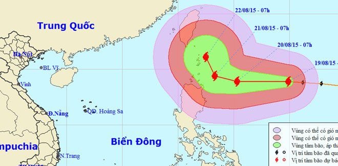 |
| Typhoon Goni with winds of 185 km/h is moving into the East Sea. Photo: NCHMF. |
Today and tonight, the storm is moving mainly westward, at about 20 km per hour and continues to strengthen. On the morning of August 20, the storm's center was about 340 km from Luzon Island with the strongest winds near the center reaching level 16 (185-200 km/h), gusting to level 17.
The storm then continued to move mainly westward at a speed of 10 km/h and approached Luzon island on August 21.
Mr. Hoang Duc Cuong, Director of the National Center for Hydro-Meteorological Forecasting, said that in 2015 there will be about 9-10 storms and tropical depressions active in the East Sea.
According to Mr. Cuong, although the number of storms is less than other years, according to statistics, years with El Nino have recorded strong and rare storms such as Linda (1997), Xangsane (2006) and Ketsana (2009). These storms have caused great damage to people and property in the South and Central regions.
According to Zing.vn
