Storm Conson (storm number 5) with level 13 winds is moving from Quang Tri to Quang Ngai.
Storm No. 5 is moving at a constantly changing speed, likely heading towards the sea area from Quang Tri - Quang Ngai with the strongest wind near the storm center at level 10-11 (90-115 km/h), gusting to level 13.
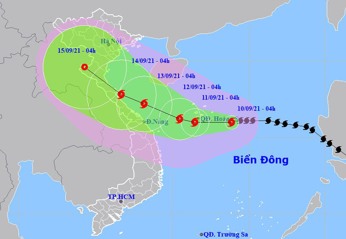
According to the National Center for Hydro-Meteorological Forecasting, at 4:00 a.m. on September 10, the center of storm No. 5 (international nameTyphoon Conson- Con Son storm) at about 16.0 degrees North latitude; 113.9 degrees East longitude, about 220 km East Southeast of Hoang Sa archipelago. The strongest wind near the storm center is level 10 (90-100 km/h), gusting to level 12. The radius of strong winds from level 6, gusting to level 8 or higher is about 160 km from the storm center.
 |
| Forecast of location and direction of storm No. 5. Source: National Center for Hydro-Meteorological Forecasting |
It is forecasted that in the next 24 hours, storm No. 5 will move mainly westward, at about 15 km per hour and is likely to strengthen. At 4:00 a.m. on September 11, the storm center will be at about 16.0 degrees North latitude; 111.5 degrees East longitude, right on the Hoang Sa archipelago. The strongest wind near the storm center is level 11 (100-115 km/h), gusting to level 13.
Dangerous areas in the East Sea in the next 24 hours (strong winds from level 6, gusts from level 8 or higher): from latitude 14.0 to 18.5 degrees North; from longitude 109.5 to 116.0 degrees East. All vessels operating in the dangerous area are at high risk of being affected by strong winds, big waves and whirlwinds.In the next 24 to 48 hours, storm No. 5 will move slowly westward, traveling about 5 km per hour. At 4:00 a.m. on September 12, the storm's center will be at about 16.2 degrees North latitude; 110.5 degrees East longitude, just west of the Hoang Sa archipelago, about 300 km east of the Thua Thien Hue-Da Nang coast. The strongest wind near the storm's center is level 11 (100-115 km/h), gusting to level 13.
Dangerous areas in the East Sea in the next 24-48 hours (strong winds from level 6, gusts from level 8 or higher): from latitude 14.5 to 18.5 degrees North; from longitude 107.0 to 113.5 degrees East. All vessels operating in the dangerous areas are at high risk of being affected by strong winds, big waves and whirlwinds.
In the next 48 to 72 hours, storm No. 5 will move in a West-Northwest direction, traveling about 10 km per hour. At 4:00 a.m. on September 13, the center of the storm was at about 17.2 degrees North latitude; 108.2 degrees East longitude, right on the sea from Quang Tri to Quang Ngai. The strongest wind near the center of the storm is level 10-11 (90-115 km/h), gusting to level 13.
During the next 72 to 120 hours, storm No. 5 will move northwest at about 10 km per hour and its intensity will decrease.
Warning of strong winds and high waves at sea
In the North and Central East Sea (including Hoang Sa archipelago), there will be storms, strong whirlwinds of level 7-8, near the storm center level 9, then increasing to level 10-11, gusting to level 13; waves from 4-6 m high; rough seas. Disaster risk warning level in the North and Central East Sea: level 3.
In addition, due to the influence of the gradually strengthening Southwest monsoon, the central and southern East Sea (including Truong Sa archipelago), the sea area from Binh Thuan to Ca Mau has strong Southwest wind level 5, sometimes level 6, gusting to level 7-8, rough sea.
