The storm hit Quang Ninh and Hai Phong earlier and more intensely.
Typhoon Rammasun is expected to make landfall around the morning of July 19th – earlier than anticipated and with greater intensity. The eye of the storm is expected to be in the Quang Ninh – Hai Phong area with wind speeds of level 10, 11, gusting to level 12, 13.
On the afternoon of July 16th, Minister of Agriculture and Rural Development Cao Duc Phat chaired a meeting to respond to Typhoon No. 2 (Typhoon Rammasun), which entered the East Sea at 10:00 AM on July 17th.
 |
| Typhoon No. 2 is currently at level 13, with gusts reaching levels 15-16 (Photo: NCHMF) |
.
The storm is expected to make landfall on the morning of July 19th.
According to Mr. Hoang Duc Cuong, Director of the Center for Meteorological and Hydrological Forecasting, compared to the forecast on July 15th, the storm has shown notable new developments: it arrived earlier and is stronger in intensity.
"The storm is moving into the warmest part of the South China Sea and is slightly deviating to the west, so it's moving faster and is more intense," Mr. Cuong explained.
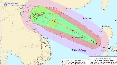
Currently, forecasts from various meteorological stations around the world all agree on the intensity and direction of Typhoon Rammasun (heading between west-northwest and northwest towards Hainan Island in China, then entering the Gulf of Tonkin in Vietnam).
The storm is expected to continuously intensify; after entering the South China Sea, it will continue to move between the west-northwest and northwest with an intensity of level 13-14, gusting to 15-16, before making landfall on Hainan Island on the morning of July 18th.
After entering Hainan Island, the storm is likely to weaken by 1-2 levels before entering the Gulf of Tonkin in the afternoon/night of July 18th with wind speeds of level 11-12. Upon making landfall in the coastal areas of Quang Ninh and Hai Phong around the morning of July 19th, the storm will still be strong, around level 10-11, with gusts of level 12-13, and there is a possibility of it becoming stronger.
The storm then continued to move and made landfall in the northeastern provinces (primarily Quang Ninh and Hai Phong) on July 19th, before heading west and weakening.
Rain will occur and last from July 18-22, mainly from the afternoon of July 19 and the morning of July 20, concentrated mainly along the northeastern coast, northeastern Northern Vietnam, and the northern midland region with rainfall amounts of 200-300mm. The northern midland region and parts of the northern central region will be the heaviest areas. The northern mountainous region will experience the heaviest rainfall on July 20.
Typhoon No. 2 is currently at level 13, with gusts reaching levels 15-16. At 4 PM on July 16th, the typhoon's center was located at approximately 15.4 degrees North latitude and 118.5 degrees East longitude, about 710km east-southeast of the Hoang Sa (Paracel) Islands. The strongest winds near the center of the typhoon reached level 13 (134 to 149 km per hour), with gusts of level 15 and 16. As of 4 PM on July 17th, the typhoon's center was located at approximately 17.8 degrees North latitude and 114.1 degrees East longitude, about 230km east-northeast of the Hoang Sa (Paracel) Islands. The strongest winds near the center of the typhoon were at level 13 or 14 (134 to 166 km per hour), with gusts reaching level 16 or 17. As of 4 PM on July 18th, the typhoon's center was located at approximately 19.8 degrees North latitude and 110.1 degrees East longitude, north of Hainan Island (China). The strongest winds near the center of the typhoon reached levels 13 and 14 (134 to 166 km per hour), with gusts reaching levels 16 and 17. |
The basic response measures must be completed by July 17th.
The Central Steering Committee for Flood and Storm Prevention and Control announced that the provinces of Quang Ninh, Hai Phong, and Nam Dinh have prepared response plans for the storm. Provinces from Quang Ninh to Phu Yen are continuing to count boats and ships, and are ready with contingency plans for when the storm makes landfall, such as evacuating residents and preventing urban flooding. The northern mountainous region is implementing measures to cope with landslides and heavy rains.
Mr. Phat suggested that discussions should be held on how to respond to the storm in the Gulf of Tonkin so that local authorities could be notified by the evening of July 16th to prepare for the response.
“The forecast is that the storm will almost certainly reach the shore by noon on July 19th. A storm like this is very strong. Experience shows that according to meteorological centers, the storm's center is predicted to be at 12 noon, but by 8-9 am the wind will already be very strong. Therefore, by the morning of July 19th, almost nothing can be done. All preparations for responding to the storm must be completed by July 17th-18th, both at sea and on land,” Mr. Phat instructed.
The Director of the Central Meteorological and Hydrological Forecasting Center also stated that by the evening of July 18th, winds in the Gulf of Tonkin had already strengthened to level 8. Therefore, Mr. Phat emphasized that all preparations "must be basically completed by July 17th."
On the morning of July 18th, the Central Steering Committee for Flood and Storm Prevention held an online meeting with localities starting at 7:00 AM to discuss plans for prohibiting sea travel and evacuating people.
According to Vietnamnet

