Typhoon Kalmaegi: Forecast to make landfall in South Central Vietnam with wind gusts up to level 17.
Typhoon Kalmaegi is intensifying as it moves rapidly into the South China Sea, and is expected to make landfall in the South Central region of Vietnam on the night of November 6th - early morning of November 7th, causing strong gusts of wind and widespread heavy rain.
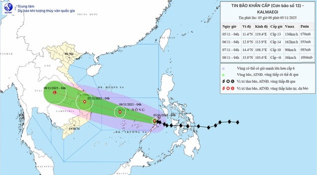
According to the National Center for Meteorological and Hydrological Forecasting, Typhoon Kalmaegi has officially entered the South China Sea, becoming the 13th typhoon of 2025. Its current wind intensity is level 14, with gusts up to level 16, and it continues to strengthen as it approaches the central coast.
Forecasts indicate that Typhoon Kalmaegi will move rapidly in a west-northwest direction at a speed of approximately 25 km/h, and is likely to make landfall in the South Central region of Vietnam around the night of November 6th to the early morning of November 7th.
According to Mr. Mai Van Khiem, Director of the National Center for Meteorological and Hydrological Forecasting, Typhoon Kalmaegi formed east of the Philippines, initially as a tropical depression but quickly intensified. Its rapid movement and wide circulation structure have placed it among the strongest typhoons of the year so far.
Experts assess that Typhoon Kalmaegi has similar characteristics to two historical typhoons, Damrey (2017) and Molave (2020), both of which previously hit the South Central region and caused severe damage.
Meteorological data indicates that as Typhoon Kalmaegi approached the coast, factors that weaken the storm, such as cold air or wind shear, were at low levels. Therefore, the typhoon could maintain its strong intensity until landfall, bringing fierce gusts of wind and extremely heavy rainfall.
From the afternoon of November 4th, even though Typhoon Kalmaegi had not officially entered the East Sea, the forecasting agency issued an emergency warning, requesting localities from Da Nang to Khanh Hoa to raise their vigilance level, implement plans to evacuate residents and protect ships and boats before the strong storm's circulation.
On the morning of November 5th, Typhoon Kalmaegi continued to move into the central South China Sea, causing strong winds of force 7-8, later increasing to force 9-11; near the center of the typhoon, winds reached force 12-14, with gusts up to force 17. Sea waves were 5-7 meters high, reaching up to 10 meters near the center of the typhoon. It is expected that the Spratly Islands will be the first to be affected by Typhoon Kalmaegi, with very strong winds and large waves, posing a danger to offshore structures and ships operating at sea.
From early morning on November 6th, the sea area from Da Nang to Khanh Hoa (including Ly Son Island) will experience gradually increasing winds of force 6-7, then increasing to 8-11, reaching force 12-14 near the storm's center, with gusts up to force 17. Coastal areas from Thua Thien Hue to Dak Lak will experience waves 4-6 meters high, with areas near the center of Typhoon Kalmaegi reaching up to 8 meters, causing extremely rough seas and a risk of storm surge of 0.3-0.6 meters.
The meteorological agency warned that all vessels, mooring areas, and aquaculture farms in the region directly affected by Typhoon Kalmaegi need to be evacuated or moved urgently. Strong gusts of wind combined with large waves could endanger fishing vessels, oil rigs, and coastal power systems.
Local authorities from Quang Tri to Khanh Hoa have been instructed to implement emergency response plans, reinforce houses, trim trees, and prepare rescue forces. Typhoon Kalmaegi is expected to cause prolonged heavy rainfall, with some areas receiving over 400 mm per event, posing a high risk of flash floods and landslides in mountainous areas.
The Kalmaegi storm system is likely to cause very heavy rainfall in the area from Da Nang to Dak Lak from November 6-8, with total rainfall generally ranging from 200-400 mm, and locally exceeding 600 mm. Provinces from Khanh Hoa and Lam Dong to Hue will also experience heavy rainfall of 150-300 mm, with localized amounts exceeding 450 mm.
After making landfall, Typhoon Kalmaegi moved inland and gradually weakened, but its circulation could still cause prolonged rain until November 9th in the North Central region. The meteorological agency warned of a high risk of thunderstorms, tornadoes, lightning, and strong gusts of wind both before and during the typhoon's landfall.
Typhoon Kalmaegi is considered one of the strongest and most dangerous typhoons of 2025. Coastal provinces in Central Vietnam need to urgently implement preventative measures, closely monitor the latest weather forecasts, and ensure the absolute safety of their residents.

