Latest news on storm Kalmaegi: Moving fast, may enter Central Vietnam on November 7
Typhoon Kalmaegi continues to move rapidly and intensify. It is forecast that around November 5, the storm will enter the East Sea, becoming storm number 13; after that, it will likely move inland to the Central region.
According to the National Center for Hydro-Meteorological Forecasting, as of 1:00 a.m. this morning (November 3), the center of storm Kalmaegi was located in the sea east of the central Philippines. The strongest wind near the center of the storm was 103-117 km/h, gusting to level 14, up 2 levels compared to 4:00 p.m. yesterday (November 2).
The storm is currently moving rapidly to the West at a speed of about 30km/h.
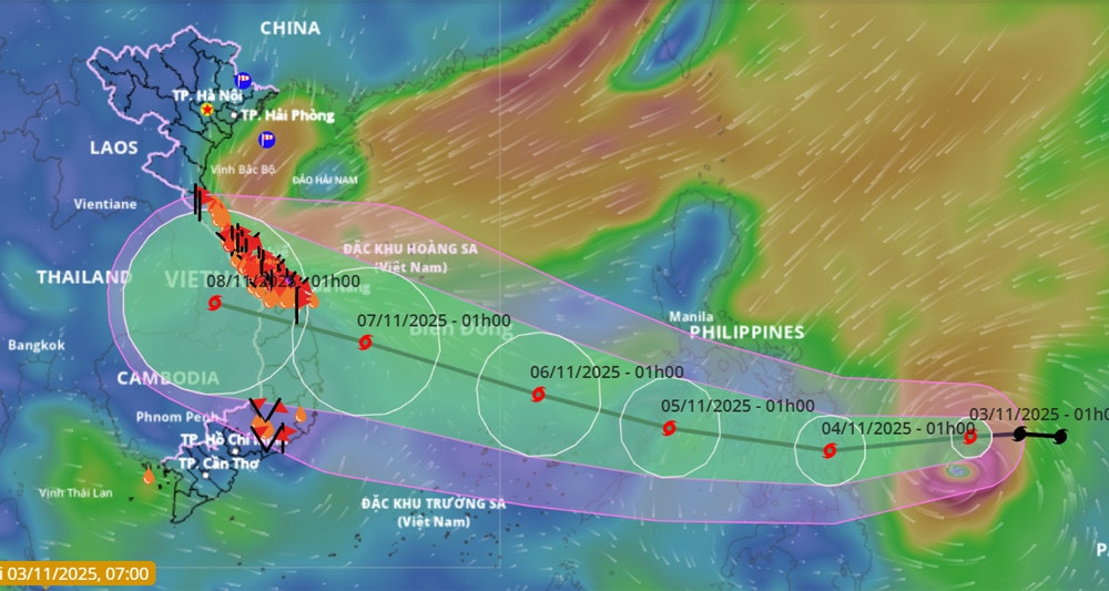
It is forecasted that in the next 24 hours, the storm will continue to move rapidly westward at a speed of about 20km/h and will likely intensify. By 1am tomorrow morning (November 4), the storm center will be in the sea east of the central Philippines with a strength of level 12 (118-133km/h), gusting to level 15.
In the next 24 to 48 hours, the storm will change direction, moving west-northwest at a speed of 20-25km/h. At 1am on November 5, the center of the storm was over the western central region of the Philippines, maintaining a level 12 intensity, gusting to level 15.
It is forecasted that around the early morning of November 5 (Wednesday), storm Kalmaegi is likely to enter the East Sea and become the 13th storm of 2025. After entering the East Sea, storm Kalmaegi will continue to move in the West-Northwest direction at a speed of about 20-25km/h, and the storm's intensity is likely to increase.
At 1:00 a.m. on November 6, the storm's eye was located in the central East Sea, with its intensity increasing by one level, to level 13 (134-149 km/h), gusting to level 17.
After that, the storm continued to move mainly in the West-Northwest direction, traveling about 20-25km per hour and its intensity was likely to increase.
At around 1am on November 7, the eye of the storm was over the sea of the Central provinces. At this time, the storm intensity could be as strong as level 14 (150-166km/h), gusting to level 17.
Previously, the meteorological agency predicted that around November 7, the storm would likely move inland, with the focus area likely to be directly impacted from Da Nang to Khanh Hoa.
The East Sea is about to welcome 2-3 more storms in November, cold air increases sharply.
The storm may cause strong winds and heavy rain in the provinces of the Central Central, South Central, and Central Highlands regions from the night of November 6 to 9. The meteorological agency noted that the storm forecast is still affected by many large-scale factors and may change, so authorities and people need to monitor regularly and update new forecasts.
Due to the influence of the storm, from around the afternoon of November 4, the sea area east of the central East Sea will have winds gradually increasing to level 6-7, then increasing to level 8-9, the area near the storm center will have strong winds of level 10-12, gusting to level 14-15, waves 5-7m high.
During November 5-6, in the central East Sea area (including Truong Sa special zone), the sea area off the coast of Da Nang - Khanh Hoa is likely to be affected by strong winds of level 12-14, gusting above level 17, and waves of 8-10m high.
All ships and structures operating in the above-mentioned dangerous areas are strongly affected by storms, whirlwinds, strong winds and big waves.


.jpg "Nghệ An chủ động ứng phó với áp thấp nhiệt đới có khả năng mạnh lên thành bão")
