Storm No. 12 with level 15 wind gusts moves hundreds of kilometers further
At 4:00 a.m. on November 2, the storm center was about 510km east-northeast of Hoang Sa archipelago.
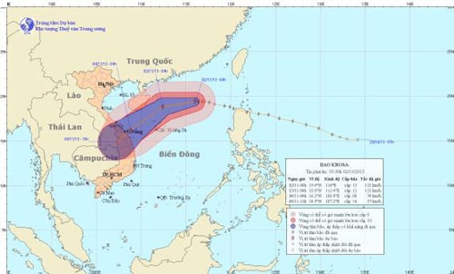
According to the National Center for Hydro-Meteorological Forecasting, at 4:00 a.m. on November 2, the eye of the storm was located at approximately 19.4 degrees North latitude; 116.0 degrees East longitude, approximately 510 km East-Northeast of the Hoang Sa archipelago. The strongest winds near the eye of the storm were at level 12 and 13 (118 to 149 km per hour), gusting to level 14 and 15.
 |
| Path of the storm |
It is forecasted that in the next 24 hours, the storm will move mainly in the West direction and then possibly change direction to the West Southwest, traveling about 15km per hour. At 04:00 on November 3, the center of the storm was at about 18.8 degrees North latitude; 112.4 degrees East longitude, about 230km north of Hoang Sa archipelago. The strongest wind near the center of the storm is level 12, level 13 (ie from 118 to 149 km per hour), gusting to level 14, level 15.
In the next 24 to 48 hours, the storm is likely to change direction to move between West Southwest and Southwest, traveling about 15 - 20km per hour. At 04:00 on November 4, the center of the storm was at about 16.2 degrees North latitude; 108.8 degrees East longitude, right on the sea of Quang Tri - Quang Ngai provinces. The strongest wind near the center of the storm is level 8 (ie from 62 to 74 km per hour), gusting to level 9, level 10.
During the next 48 to 60 hours, the storm will continue to move in the West Southwest and Southwest direction, traveling about 15km per hour.
Due to the influence of the storm circulation, the North East Sea area (including the sea area northeast of Hoang Sa archipelago) has strong winds of level 8 - 10, the area near the storm's center has strong winds of level 11 - 13, gusting to level 14, level 15. The sea is very rough./.
According to VOV
