Storm No. 2 heads towards Nghe An, causing heavy rain and wind gusts of level 9-10
The National Center for Hydro-Meteorological Forecasting said that on the afternoon of July 15, the tropical depression in the waters of the Hoang Sa archipelago strengthened into a storm, becoming the second storm this year and internationally known as storm Talas.
According to the National Center for Hydro-Meteorological Forecasting, at 7:00 p.m. on July 15, the center of storm No. 2 was located at about 17.1 degrees north latitude and 111.2 degrees east longitude, about 210 km southeast of Hainan Island (China). Near the center of the storm, the strongest wind reached level 8, that is, from 60 - 75 km/h, gusting to level 9 - 10. It is forecasted that in the next 24 hours, the storm will move west-northwest, traveling 15 - 20 km per hour and may become stronger.
As of 7 p.m. today (July 16), the center of the storm was at about 18.7 degrees north latitude and 107.4 degrees east longitude, about 160 km east-southeast of the coast of Thanh Hoa to Ha Tinh provinces. The strongest wind near the center of the storm was at level 9, that is, 75 - 90 km/h, gusting to level 10.
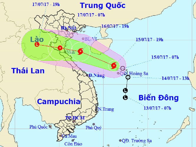 |
| Forecast map of the path of storm No. 2. Photo: National Center for Hydro-Meteorological Forecasting |
Also according to the National Center for Hydro-Meteorological Forecasting, in the next 24 - 36 hours, the storm will move in the West-Northwest direction, at a speed of 15 - 20 km/h and make landfall from Thanh Hoa to Ha Tinh provinces, then gradually weaken into a tropical depression. At 7:00 a.m. on July 17, the center of the tropical depression was at about 19.1 degrees north latitude; 105.1 degrees east longitude. The strongest wind in the area near the center of the tropical depression is level 7, that is, from 50 - 60 km/h, gusting to level 8 - 9.
| On the afternoon of July 15, the Central Steering Committee for Natural Disaster Prevention and Control and the National Committee for Search and Rescue sent an urgent telegram to coastal provinces and cities from Quang Ninh to Quang Ngai and provinces in the Northern and Central regions, requesting close monitoring of the developments of storm No. 2 and proactively having response plans; for provinces from Quang Ninh to Ha Tinh, all response work to the storm must be completed before 5:00 p.m. on July 16. |
Due to the influence of storm No. 2, from the morning of July 16, in the Gulf of Tonkin, the wind gradually increased to level 6 - 7, near the center of the storm, it was level 8 - 9, gusting to level 10, waves were 3 - 5 m high. The sea was very rough. Around the evening and night of July 16, coastal areas from Hai Phong to Ha Tinh had strong winds of level 6 - 8, gusting to level 9 - 10. Quang Ninh, Quang Binh provinces and deep inland areas from Hai Phong to Ha Tinh had gusts of level 6 - 8.
Due to the storm's impact, the northern and north central provinces will have rain from the afternoon of July 16 to 18. Heavy rain is forecast in Thanh Hoa and Nghe An provinces with total rainfall of 250 - 350 mm. The northern delta provinces and Ha Tinh will have widespread rain of 150 - 250 mm; the provinces of Hoa Binh, Son La, Phu Tho, Yen Bai, and Dien Bien will have rain of 100 - 200 mm; the provinces from Quang Binh to Thua Thien-Hue will have rain of 50 - 150 mm.
Heavy rains caused by storm No. 2 have put many urban areas and cities in the Northern and Central provinces at risk of flooding. Flash floods and landslides have increased again in the northern mountainous provinces, as this area has had continuous rain since the beginning of June.
Proactively banning the sea, ready to respond to floods
On the morning of July 15, in Hanoi, the Central Steering Committee for Natural Disaster Prevention and Control held an online meeting with the Northern and Central provinces to discuss solutions to respond to the tropical depression strengthening into storm No. 2.
Mr. Tran Quang Hoai, Standing Member of the Central Steering Committee for Natural Disaster Prevention and Control, Deputy Director General of the General Department of Irrigation (Ministry of Agriculture and Rural Development) requested that localities in the area directly affected by the storm must complete their response preparations on July 16 and proactively issue a sea ban to prevent ships and boats from going out to sea.
Provinces that are forecast to have heavy rains should review all reservoir and dam projects, assess water storage capacity, and ensure safety for the projects. In particular, the Northern Delta region should proactively drain buffer water, be ready to respond to heavy rains and the possibility that reservoirs in Son La and Hoa Binh will have to discharge floodwaters.
The National Committee for Search and Rescue and the Ministry of National Defense mobilized 289,223 officers, soldiers, militia and self-defense forces with over 86,319 vehicles and equipment to participate in the prevention of storm No. 2, ready to perform rescue missions. Among them, there are 6 aircraft of the Air Defense - Air Force; 6 ships of the Navy; 4 ships of the Coast Guard and 58 ships of the Border Guard along with hundreds of amphibious vehicles and special vehicles of military regions 1, 2, 3, 4, 5 on standby, ready to perform missions when ordered.
According to TNO
| RELATED NEWS |
|---|


.jpg "Thời tiết Nghệ An ngày 25/9: Có mưa vừa đến mưa to, có nơi mưa rất to và dông")