Storm No. 3 enters Leizhou Peninsula (China)
It is forecast that in the next 12 hours, the storm will move deep into the mainland of Guangxi province and weaken into a tropical depression.
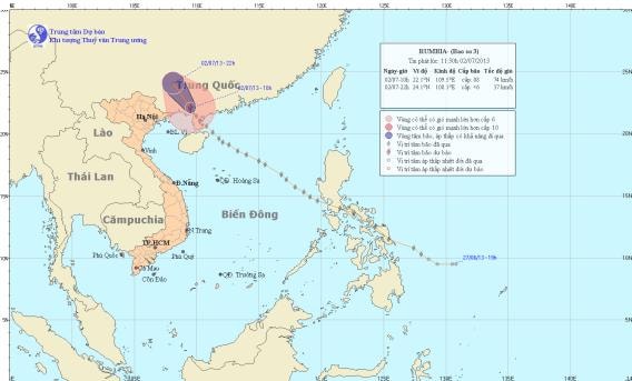
The National Center for Hydro-Meteorological Forecasting said: Early morning on July 2, storm No. 3 entered the mainland north of Leizhou peninsula (China).
At 10:00, the eye of the storm was located at approximately 22.1 degrees North latitude; 109.5 degrees East longitude, on the mainland southeast of Guangxi province (China), approximately 180km East Northeast of Mong Cai (Quang Ninh). The strongest wind near the eye of the storm was at level 8 (62 to 74 km per hour), gusting to level 9 and level 10.
The path of storm No. 3 (Photo: TTDBKTTV)
Forecast in the next 12 hours, the storm will move in the direction between Northwest and North Northwest, about 20 - 25km per hour, go deep into the mainland of Guangxi province (China) and weaken into a tropical depression. After that, the tropical depression will continue to weaken into a low pressure area.
At 10:00 p.m. on July 2, the center of the low pressure area was at about 24.1 degrees North latitude; 108.1 degrees East longitude. The strongest wind in the center of the low pressure area decreased to below level 6 (ie below 39 km per hour).
Due to the storm's influence, the northern sea area of the Gulf of Tonkin this afternoon (July 2) will have strong winds of level 6, gusts of level 7, level 8, and showers and thunderstorms. The sea will be rough. In the North, there will be rain, moderate rain, while the mountainous areas in the North and the Northeast will have moderate to heavy rain and thunderstorms. During thunderstorms, beware of strong gusts of wind, and in mountainous areas, beware of flash floods and landslides./.
According to (vov.vn) - LT


