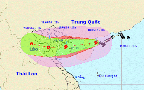
Storm No. 3 continues to strengthen, gusting to level 11-13
It is forecasted that in the next 6 hours, the storm will move west and continue to strengthen, directly affecting the northeastern and north central provinces.
According to the National Center for Hydro-Meteorological Forecasting, in the past 3 hours, storm No. 3 has been moving mainly in a westerly direction, at a speed of 15 km/h. Due to the storm's influence, in Bach Long Vi there have been strong winds of level 8, gusts of level 10, in Co To, Cua Ong (Quang Ninh) there have been strong gusts of level 10; other places in the Northern coastal region have had strong gusts of level 6-8.
At 4:00 a.m. on August 19, the center of storm No. 3 was at about 20.4 degrees North latitude; 108.1 degrees East longitude, in the northern Gulf of Tonkin, about 180km east of the Hai Phong-Ninh Binh coast. The strongest wind near the center of the storm was level 9 (75-90km/h), gusting to level 10-12.
 |
| Forecast of the movement of storm No. 3 |
It is forecasted that in the next 6 hours, the storm will move westward, traveling 15-20km per hour and continue to strengthen, directly affecting the northeastern and north central provinces. At 10:00 on August 19, the storm center was located at about 20.4 degrees North latitude; 106.8 degrees East longitude, right on the coastal areas of Hai Phong-Ninh Binh provinces. The strongest wind near the storm center is level 9-10 (75-100km/h), gusting to level 11-13.
Due to the influence of the storm circulation, in the Gulf of Tonkin (including the island districts of Bach Long Vi, Cat Hai, Co To, Van Don), there are strong winds of level 8, the area near the storm's center has strong winds of level 9-10, gusts of level 11-13, waves from 4-6m high. The sea is very rough. Natural disaster risk level 3.
In the provinces of Quang Ninh, Hai Phong, Thai Binh, Nam Dinh, Ninh Binh, and northern Thanh Hoa, winds will gradually increase to level 8-10, gusting to level 11-13. Natural disaster risk level 3.
It is forecasted that in the next 6 to 12 hours, the storm will move westward at 15-20km per hour, making landfall in the provinces of Hai Phong-Ninh Binh and continuing to directly affect the provinces in the Northeast and North Central regions. At 4:00 p.m. on August 19, the center of the storm will be at about 20.4 degrees North latitude; 105.6 degrees East longitude, on the mainland of the Northern Delta provinces and northern Thanh Hoa. The strongest wind near the center of the storm is at level 8 (60-75km/h), gusting at level 10-12.
In the provinces and cities of Quang Ninh, Hai Phong, Thai Binh, Nam Dinh, Ninh Binh, and northern Thanh Hoa, there will continue to be strong winds of level 8-10, gusting to level 11-13. Other places in the Northern Delta and midlands and Nghe An and Ha Tinh will have strong winds of level 6-7, gusting to level 8-10. The coastal areas from southern Quang Ninh to Nam Dinh will have storm surges combined with high tides of 3-4m. Natural disaster risk level is level 3.
In the next 12 to 24 hours, the storm will move mainly westward, at a speed of 15-20km per hour, moving inland and gradually weakening into a tropical depression in the upper Laos region.
Warning of heavy rain, flash floods, landslides From now until the end of August 20, heavy rains will continue to occur in large areas across the Northern and North Central regions. Total rainfall in the coastal areas of Quang Ninh-Hai Phong, the Northern Delta and midlands, Thanh Hoa-Nghe An is generally 200-300mm, in some places over 400mm. Other areas in the Northern region, Ha Tinh-Quang Binh are generally 100-200mm, in some places over 250mm. Disaster risk level 2. Water levels on the Red-Thai Binh River system, Hoang Long River, Ky Cung River, Bang River, Day River, and Dao River will rise rapidly. Flood amplitude in the upstream is 2-5m, and in the downstream is 2-3m. Flood peaks on Cau River, Thuong River, Day River, Dao River, and downstream of Thai Binh River are at alert level I; Thao River, Bang River, and Hoang Long River are at alert level II; Luc Nam River, and Ky Cung River are at alert level III; upstream of Ma River and Buoi River will rise above alert level II, downstream from alert level I to alert level II; Ca River and La River will rise to alert level I. There is a high risk of major floods, flash floods, and landslides on small rivers and streams in Lai Chau, Dien Bien, Son La, Hoa Binh, Lao Cai, Yen Bai, Phu Tho, Ha Giang, Tuyen Quang, Thai Nguyen, Bac Kan, Cao Bang, Lang Son, Quang Ninh and mountainous areas of Thanh Hoa, Nghe An, Ha Tinh provinces; flooding in the Northern Delta and low-lying areas in the North Central region (Thanh Hoa, Nghe An, Ha Tinh). Natural disaster risk level 2./. |
According to VOV
| RELATED NEWS |
|---|

