Storm No. 4 weakens into a tropical depression, Nghe An on October 8 has moderate to heavy rain
(Baonghean.vn) - According to today's forecast, Nghe An province will be cloudy with rain, scattered showers and thunderstorms, with moderate to heavy rain in some places.
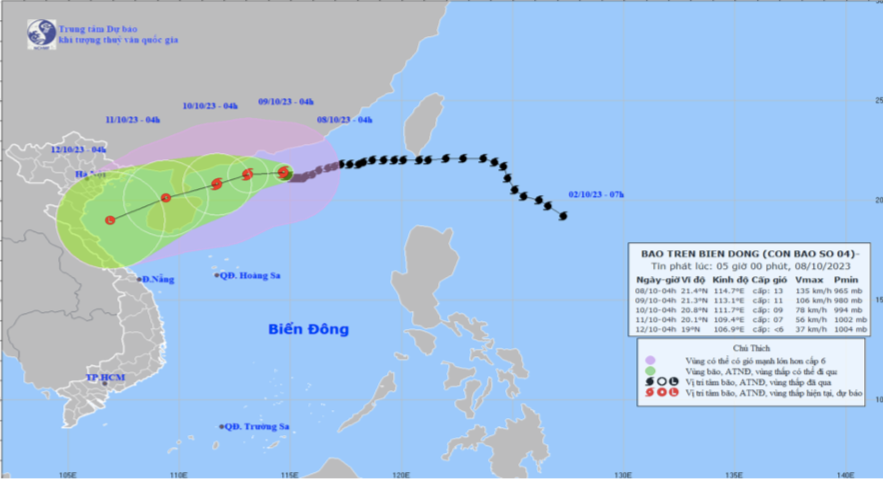
STORM NEWS IN THE EAST SEA (STORM NO. 4)
At 4:00 a.m. on October 8, the center of the storm was at about 21.4 degrees North latitude; 114.7 degrees East longitude, about 120km south of Hong Kong (China). The strongest wind near the center of the storm was level 12-13 (118-149km/h), gusting to level 16, moving slowly in the West Northwest direction at a speed of about 5km/h.
Storm forecast (in the next 24 to 72 hours):
| Forecast time | Direction, speed | Location | Intensity | Danger zone | Disaster Risk Level (Affected Area) |
| 04h/09/10 | West, about 5km/h and weakening | 21.3N-113.1E, about 300km south of Leizhou Peninsula (China) Winter | Level 10-11, level 14 | North of latitude 19.0N; 112.5-117.5E | Level 3: North of the North East Sea area |
| 04h/10/10 | West Southwest, about 5km/h and weakening | 20.8N-111.7E, about 140km south of Leizhou Peninsula (China) Winter | Level 8-9, level 12 | North of latitude 19.0N; 110.5-116.0E | Level 3: North of the North East Sea area |
| 04h/11/10 | West Southwest, about 10km/h and weakening to tropical depression | 20.1N-109.4E, in the sea northwest of Hainan Island (China) (Country) | Level 6-7, level 9 jerk | North of latitude 18.5N; 108.5-113.5E | Level 3: Northwest of the North East Sea area |
From the next 72 to 96 hours, the tropical depression moves mainly in the West Southwest direction, about 10km per hour, weakening into a low pressure area.
* Forecast of storm impact:In the next 24 to 48 hours, the northern sea area of the North East Sea will have strong winds of level 7-9, the area near the storm center will have strong winds of level 10-12, gusting to level 14; the sea will be very rough. All ships operating in this area will be affected by strong storm winds.
In the North East Sea, waves are 2.0-4.0m high, in the North Sea, waves are 4.0-6.0m high, and near the storm center, waves are 6.0-8.0m high.
* Weather in North Central region:In the next 24 hours, the clouds will change to mostly cloudy, Nghe An will have scattered showers and thunderstorms. Ha Tinh will have rain, moderate rain, some places will have heavy to very heavy rain and thunderstorms. North to northeast wind level 3.
NEWSLETTERFORECASTWEATHER ON LAND IN NGHE AN PROVINCE ON OCTOBER 8, 2023
* Coastal plain area
Cloudy with rain, showers and scattered thunderstorms, some places with moderate to heavy rain. North to northeast wind level 3.
- Temperature: 23 - 29oC
- Humidity: 85 – 95%
* Midland and mountainous areas.
Cloudy with scattered showers and thunderstorms, locally moderate to heavy. Light winds.
- Temperature: 22 - 30oC.
- Humidity: 75 – 85%
* Vinh City Area
Cloudy with occasional showers and thunderstorms. North to northeast wind force 2-3.
- Temperature: 24 - 29oC.
- Humidity: 85 – 90%
* Cua Lo and Ngu Island area
Cloudy with occasional showers and thunderstorms. North to northeast wind force 3
- Temperature: 23 - 28oC.
- Humidity: 90 – 95%
*next 48 hours:Continental high pressure continues to strengthen to the south, combined with the tropical convergence zone with an axis through the North Central region gradually weakening, so clouds change to cloudy, with scattered rain, showers and thunderstorms, locally with moderate to heavy rain.
* During thunderstorms there is a possibility of tornadoes, lightning, hail and strong gusts of wind.
