Storm No. 5 moves in the West Northwest direction
The strongest wind near the storm center is level 8 (62 to 74 km/h), gusting to level 9 and 10.
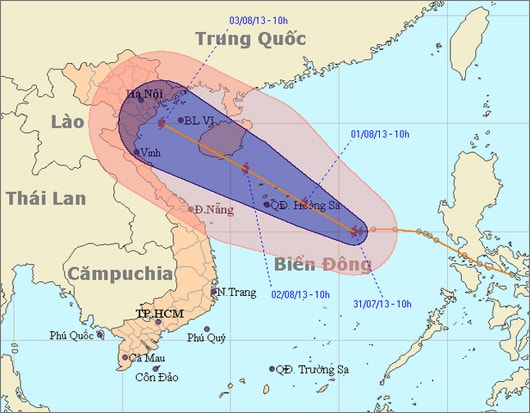
According to the National Center for Hydro-Meteorological Forecasting: At 10:00 a.m. on July 31, the center of the storm was at about 15.0 degrees North latitude; 115.7 degrees East longitude, about 430 km East Southeast of Hoang Sa archipelago.
The strongest wind near the storm center is level 8 (62 to 74 km/h), gusting to level 9 and 10.
It is forecasted that in the next 24 hours, the storm will move mainly in the West-Northwest direction at about 10-15 km per hour and may strengthen further.
At 10:00 a.m. on August 1, the center of the storm was located at approximately 16.3 degrees North latitude; 113.4 degrees East longitude, in the area east of the Hoang Sa archipelago. The strongest wind near the center of the storm was level 9 (75 to 88 km/h), gusting to level 10 and 11.
Location and path of storm number 5
In the next 24 to 48 hours, the storm is likely to change direction to move between West Northwest and Northwest, traveling about 15 km per hour. At 10:00 a.m. on August 2, the center of the storm was located at about 17.9 degrees North latitude; 110.7 degrees East longitude, in the sea southeast of Hainan Island (China). The strongest wind near the center of the storm is level 9, level 10 (ie from 75 to 102 km/h), gusting to level 11, level 12.
During the next 48 to 72 hours, the storm will continue to move in a West Northwest direction and is likely to move faster, traveling about 20 km per hour.
Due to the influence of the storm, the sea area between the North and the middle of the East Sea (including the sea area of Hoang Sa archipelago) has strong winds of level 6, level 7, then increasing to level 8, the area near the center of the storm has level 9, level 10, gusting to level 11, level 12 and there are showers and strong thunderstorms. The sea is very rough. During thunderstorms, beware of tornadoes.
In addition, due to the influence of the strong southwest monsoon, the sea area from Binh Thuan to Ca Mau and the southern East Sea (including the Truong Sa archipelago) will have strong winds of level 5, sometimes level 6, gusting to level 7, level 8 and heavy rain and thunderstorms. Rough seas. Beware of tornadoes during thunderstorms./.
According to vov.vn - LT


