Storm No. 6 is about 290km from the coast of TT Hue - Quang Ngai.
It is forecasted that in the next 24 hours, the storm will move mainly in a northwest direction, along the coast of the Central provinces.
According to the National Center for Hydro-Meteorological Forecasting: At 4:00 p.m. on August 6, the center of storm No. 6 was located at about 15.4 degrees North latitude; 111.7 degrees East longitude, in the southern area of Hoang Sa archipelago, about 290km East Northeast of the coast of Thua Thien Hue - Quang Ngai provinces. The strongest wind near the center of the storm was level 8 (ie from 62 to 74 km per hour), gusting to level 9, level 10.
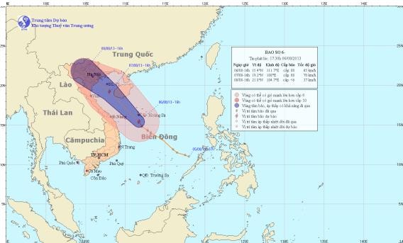
Storm path (Photo: TTDBKTTV)
It is forecasted that in the next 24 hours, the storm will move mainly in the Northwest direction, along the coast of the Central provinces, traveling about 20-25km per hour. At 4:00 p.m. on August 7, the center of the storm will be at about 19.2 degrees North latitude; 108.0 degrees East longitude, about 210km southeast of the coast of the Northeastern provinces. The strongest wind near the center of the storm is at level 8 (62 to 74 km per hour), gusting to level 9 and level 10.
In the next 24 to 48 hours, the storm will continue to move northwest, then it is likely to change direction to move west-northwest at about 20-25km per hour. Thus, around the night of August 7, the center of the storm is likely to make landfall in the northeastern provinces and weaken into a tropical depression, then the tropical depression will continue to weaken into a low pressure area.
At 4:00 p.m. on August 8, the center of the low pressure area was at about 21.8 degrees North latitude; 104.7 degrees East longitude, over the mountainous provinces of the North. The strongest wind in the center of the low pressure area decreased to below level 6 (ie below 39 km per hour).
Due to the storm's influence, the sea area of Hoang Sa archipelago and the sea area off the Central Central provinces will have strong winds of level 6 and 7, and near the eye of the storm will have winds of level 8, gusting to level 9 and 10. The sea will be rough. From tomorrow (August 7), in the Gulf of Tonkin, the wind will gradually increase to level 6 and 7, and near the eye of the storm will have strong winds of level 8, gusting to level 9 and 10.
From tomorrow evening, coastal areas of the Northeastern provinces and Thanh Hoa will see winds gradually increasing to level 6, near the storm center to level 7, level 8, gusting to level 9, level 10. In the Northern and Central Central provinces, there will be rain, moderate rain, heavy rain and thunderstorms in some places; from tomorrow night in the North, there will be moderate rain, heavy rain to very heavy rain and thunderstorms. Mountainous areas need to be on guard against flash floods and landslides.
In addition, due to the influence of the strong southwest monsoon, the sea area from Binh Thuan to Ca Mau and the South East Sea (including the Truong Sa archipelago) will have strong winds of level 5, sometimes level 6, gusting to level 7 and heavy rain and thunderstorms. Rough seas. During thunderstorms, be on guard against tornadoes./.
According to (vov.vn) - LT
