Storm No. 6 is likely to form soon, with heavy rain focusing on the Central region.
The tropical depression in the East Sea may intensify into storm No. 6, moving rapidly towards the Central region. From the evening and night of August 29-31, the midlands and deltas of the North to Da Nang will experience heavy rain, with the focus from Thanh Hoa to Hue City.
Tropical depression may strengthen into storm
According to the National Center for Hydro-Meteorological Forecasting, as of 1 p.m. on August 28, the center of the tropical depression was located in the North East Sea, about 420 km east-southeast of Hoang Sa special zone. The strongest wind near the center of the tropical depression was level 6-7 (39-61 km/h), gusting to level 9; moving southwest at a speed of 10-15 km/h.
In the next 24 hours, the tropical depression will change direction, moving west-northwest at 15-20km/h and is likely to strengthen. At 1pm on August 29, the center of the tropical depression will be over the Hoang Sa special zone. The strongest wind near the center of the tropical depression is at level 7, gusting to level 9.
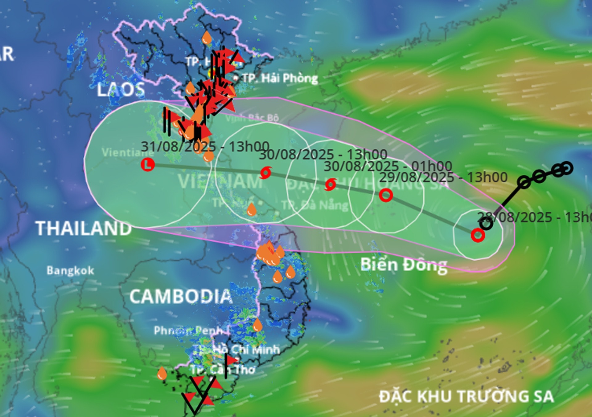
It is forecasted that in the next 12 hours, the tropical depression will maintain its direction and speed of movement, with the possibility of strengthening into a storm. If it strengthens into a storm, this will be the 6th storm in the East Sea in 2025.
At 1 p.m. on August 30, the center of the tropical depression that is likely to strengthen into a storm is located right over the sea of provinces from Nghe An to Da Nang, the storm intensity remains at level 8, gusting to level 10.
From the next 48 to 72 hours, the tropical depression (or storm) continues to move mainly in the West direction, traveling about 20km per hour and gradually weakening.
Due to the influence of the tropical depression, on the night of August 29 and the day of August 30, the western sea area of the North East Sea (including Hoang Sa special zone) and the sea area from Thanh Hoa to Da Nang: strong winds level 6-7, the area near the storm center has strong winds level 8, gusts level 10; waves 2-5m high; rough seas.
Central and Southern East Sea area (including Truong Sa special zone): strong southwest wind level 6-7, gust level 8-9; waves 2-3.5m high; rough sea.
Sea area from Khanh Hoa to Ho Chi Minh City: strong southwest wind level 6, gusting to level 7-8; waves 2-3.5m high; rough sea. Natural disaster risk level due to strong winds at sea: level 2; especially sea area east of the North East Sea level 3.
Vessels operating in the above mentioned dangerous areas are susceptible to the impact of storms, whirlwinds, strong winds and large waves.
Central region heavy rain up to 600mm
From the night of August 29 to the end of August, in the midlands and deltas of the North and from Thanh Hoa to Da Nang, there is a possibility of a storm.heavy rainlarge area
According to meteorological experts, the cause of this heavy rain is the influence of the tropical convergence zone with an axis through the North Central region connecting with a tropical depression in the eastern sea of the North East Sea. The tropical depression is moving in a West-Northwest direction and is likely to strengthen.
Specifically, from the evening and night of August 29 to August 30, the midlands, the Northern Delta and Da Nang City will have moderate rain, heavy rain and thunderstorms (50-100mm, some places will have very heavy rain over 200mm). The area from Thanh Hoa to Hue City will have heavy to very heavy rain (100-200mm, some places will have over 350mm). There is a risk of rain intensity greater than 150mm/3 hours.
In addition, in the evening and night of August 28, the area from Thanh Hoa to Lam Dong and the South will have scattered showers and thunderstorms (10-30mm, some places have heavy rain over 80mm). Risk of heavy rain: >60mm/3 hours.
The meteorological agency warned that from the night of August 30 to August 31, heavy rains will continue in the midlands and deltas of the North, from Thanh Hoa to Da Nang City. In particular, rainfall in the midlands and deltas of the North and Da Nang will be from 50-100mm, locally over 200mm; from Thanh Hoa to Hue City will be from 70-150mm, locally over 250mm.
Total rainfall from the evening and night of August 29 to August 31 in the midlands, the Northern Delta and Da Nang City will generally be from 100-200mm, locally over 400mm; in the area from Thanh Hoa to Hue City, it will generally be from 150-350mm, locally over 600mm.
Natural disaster risk level due to heavy rain, tornadoes, lightning, hail: level 1, especially in the area from Thanh Hoa to Quang Tri level 2.
The meteorological agency warns that areas with thunderstorms are likely to experience tornadoes, lightning, hail and strong gusts of wind. Heavy rains can cause flooding in low-lying areas, urban and industrial areas; flash floods in small rivers and streams; and landslides on steep slopes.

.png "Nghệ An chủ động ứng phó áp thấp có khả năng mạnh lên thành áp thấp nhiệt đới, mưa lớn, nguy cơ lũ quét, sạt lở đất")

