Storm No. 6 causes rain and risks of flash floods and landslides in the North and North Central regions.
(Baonghean.vn) - From tonight, September 16, in the northeastern sea of the Gulf of Tonkin (north of latitude 20.0 degrees North, east of longitude 108.5 degrees East), there will be storms and rain, winds gradually increasing to level 6-7, increasing to level 8 at night, gusting to level 10; waves 3-4m high; rough seas.
According to the CenterCentral Hydrometeorological Forecast, h4am September 16th, the center of the storm is located at about 20.2 degrees North latitude; 116.2 degrees East longitude, in the Northeast of the East Sea, about 400km East Southeast of Macau (China). The strongest wind near the center of the storm is level 14 (150km/hour),level 17. The range of strong winds of level 6, gusting to level 8 or higher is about 350km from the center of the storm; The range of strong winds of level 10 or higher is about 150km from the center of the storm.
Forecast for the next 24 hours,The storm is moving in the West Northwest direction, traveling 25-30km per hour. From this evening (September 16), storm No. 6 will make landfall in the southern part of Guangdong province (China) and weaken rapidly. At 4:00 a.m. on September 17, the center of the storm will be at about 22.4 degrees North latitude; 109.8 degrees East longitude, on the southern part of Guangdong-Guangxi provinces (China). The strongest wind near the center of the storm is level 9 (80km/hour).level 11. The range of strong winds of level 6, gusting to level 8 or higher is about 180km from the center of the storm.
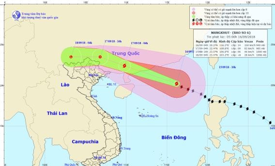 |
| Path and location of storm No. 6. Photo: National Center for Hydro-Meteorological Forecasting |
Due to the influence of the storm, in the North East Sea today there will be stormy rain, strong winds of level 11-12, the area near the storm's eye will have strong winds of level 13-14.level 16; rough seas.
From tonight, September 16, in the northeastern sea of the Gulf of Tonkin (north of latitude 20.0 degrees North, east of longitude 108.5 degrees East), there will be storms and rain, winds gradually increasing to level 6-7, and at night increasing to level 8.,level 10; waves 3-4m high; rough sea.
Dangerous areas in the East Sea in the next 24 hours (strong wind level 6 or higher): North of latitude 17.0 degrees North; East of longitude 110.0 degrees East.Disaster risk level: level 3.
Over the next 24 to 48 hours,The storm moved west-northwest at about 25km per hour, moving deep into the mainland of Guangxi province (China) and weakened into a tropical depression, then a low pressure area. At 4:00 a.m. on September 18, the center of the low pressure area was at about 23.5 degrees North latitude; 103.2 degrees East longitude, on the mainland south of Yunnan province (China). The strongest wind in the center of the low pressure area decreased to below level 6 (below 40km/h).
Due to the influence of the southern circulation of storm No. 6, tomorrow (September 17), in the North of Quang Ninh there will be strong winds of level 6-7, gusting to level 9; in the provinces of Lang Son and Cao Bang there will be strong winds of level 6, gusting to level 8; in the provinces of Hai Phong, Bac Giang, Bac Kan and Ha Giang there will be gusting to level 6-7; other provinces in the North and North Central regions will be less affected by the strong winds of storm No. 6.Disaster risk level: level 3.
Heavy rain warning:Due to the influence of the southern circulation of storm No. 6, from early morning of September 17 to September 18, the Northeast region will have heavy to very heavy rain with common rainfall of 100-150mm, especially in Lang Son and Cao Bang 150-200mm. The Viet Bac and Northwest regions will have moderate to heavy rain with common rainfall of 50-100mm, especially in Ha Giang, Lao Cai and Lai Chau 100-150mm. Other areas in the North and Thanh Hoa will have rain, moderate rain.
Flood warning:From September 17-18, a flood will appear in the upper reaches of the Red River-Thai Binh River system with a flood amplitude of 2-5m. During this flood, the flood peak of Thao River and the upper reaches of Lo River will be at level BĐ2 - BĐ3; Ky Cung River and Bang Giang River will be at level BĐ1 - BĐ2; and the upper reaches of Thai Binh River will be at level BĐ1.
Flash flood and landslide warning:There is a high risk of flash floods and landslides in the northern mountainous provinces and Thanh Hoa, especially in the provinces of Quang Ninh, Lang Son, Cao Bang, Bac Kan, Ha Giang, Lao Cai, Yen Bai, Son La, Lai Chau; Flooding in low-lying areas and urban areas in the provinces of Quang Ninh, Lang Son, Cao Bang, Bac Giang.Warning level of natural disaster risk due to floods, inundation, landslides: level 1-2.
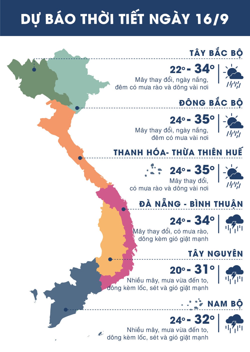 |
| Temperature on September 16 in regions across the country. Photo: news.zing.vn |