Storm No. 7 heads straight for North Central Vietnam, Nghe An has strong winds gusting to level 10
(Baonghean.vn) - The North Central Hydrometeorological Station has just issued an emergency storm warning for storm number 7. Since this morning (October 14), the wind in the North Central region has gradually increased to level 7, then increased to level 8, and near the storm center it is level 9 - level 10.
According to forecast, at Nga Son station, strong winds of level 5, gusts of level 6 were observed; at Hon Ngu island, strong winds of level 5, gusts of level 7 were observed.
4 o'clock,storm centerat about 19.7 degrees North latitude; 108.2 degrees East longitude, right on the Gulf of Tonkin, about 70 km southeast of Bach Long Vi island. The strongest wind near the storm center is level 9 (75-90 km/hour).level 11.Radius of strong winds from level 6, gusting from level 8 or higher is about 180km from the center of the storm.
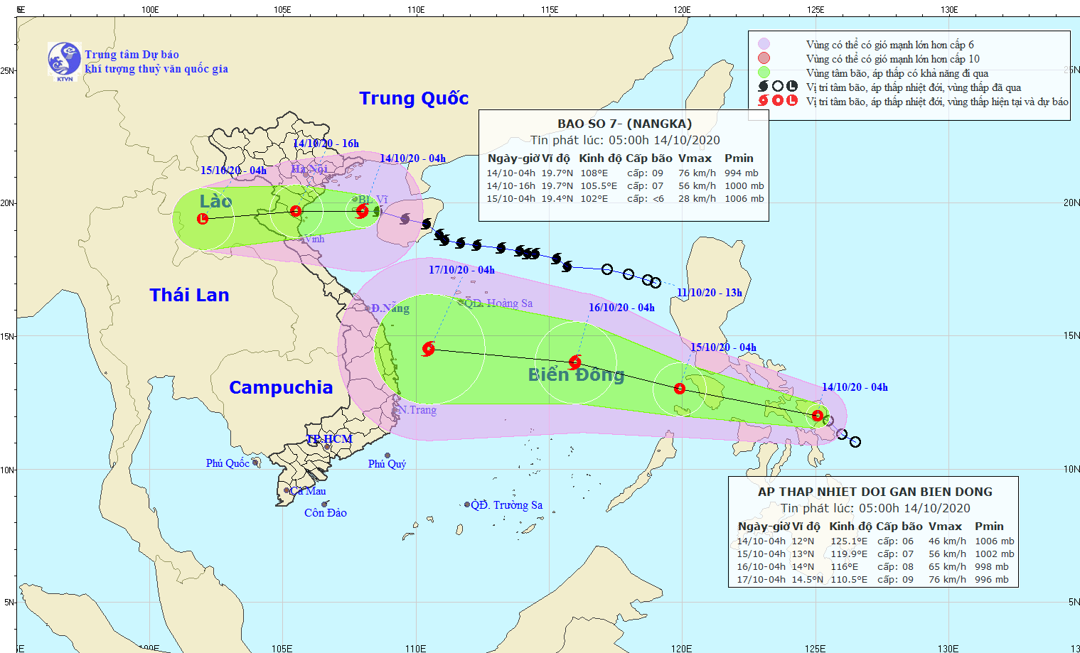 |
| Direction and path of storm No. 7. Photo: North Central Hydrometeorological Station. |
Forecast for the next 12 hours,The storm moved westward, traveling about 20km per hour, making landfall in the provinces from Thai Binh to Nghe An with strong winds of level 7-8, gusting to level 10, then gradually weakening into a tropical depression. At 4:00 p.m. on October 14, the center of the tropical depression was at about 19.7 degrees North latitude; 105.5 degrees East longitude, on the mainland along the coast of the provinces from Thai Binh to Nghe An. The strongest wind near the center of the tropical depression was strong at level 7 (50-60km/hour).level 9. The radius of strong winds from level 6, gusting from level 8 or higher is about 80km from the center of the tropical depression.
Over the next 12 to 24 hours,tropical depressionMoving west at about 20km per hour, it continued to move inland and weakened into a low pressure area over upper Laos.
Storm danger zones in the next 24 hours(strong wind level 6 or higher, gusts from level 8 or higher): North of the Gulf of Tonkin, from latitude 17.5 to latitude 21.0 degrees North. All vessels operating in the danger zone are at high risk of being affected by strong winds.
Strong winds, big waves at sea, storm surge in coastal areas:Due to the influence of storm No. 7, in the Gulf of Tonkin (including Bach Long Vi island district), there are strong winds of level 8, and winds near the storm's eye of level 9.level 11.
Strong winds on land:Since this morning (October 14), on the mainland coastal provinces of the North and North Central regions (from Quang Ninh to Ha Tinh), there have been strong winds of level 6-7.level 9; Inland coastal provinces from Nam Dinh to Nghe An have strong winds of level 7-8,level 10.
 |
| Dien Chau fishermen bring their boats to storm shelters on October 13. Photo by Mai Giang |
Weather situation in North Central region:
* At sea:
Since this morning(October 14),In the North Central region, the wind will gradually increase to level 7, then increase to level 8, near the storm center it will be level 9 - level 10. Gusts will be level 11, the sea will be very rough. Waves will be 3-5m high. In the coastal areas of Thanh Hoa and Nghe An, the storm surge may be 0.5m high.
* On land:
- Since this morning(14/10)On land, coastal districts in the North Central region have strong storm winds of level 6 - level 7, gusts of level 9; especially coastal areas of Thanh Hoa and Nghe An have strong winds of level 7 - level 8, gusts of level 10.
- Due to the direct impact of storm No. 7, combined with the strengthening cold air, from now until the end of October 16, Thanh Hoa, Nghe An, Ha Tinh provinces will have moderate to heavy rain, some places will have very heavy rain and thunderstorms. The total rainfall for the entire period is likely to reach: In Thanh Hoa and Nghe An: 200 - 300mm/period, some places over 350mm/period; In Ha Tinh: 100 - 200mm/period.
Disaster risk level: level 3.
NEWS ON TROPICAL LOW PRESSURE NEAR EAST SEA
At 4:00 a.m. on October 14, the center of the tropical depression is located at about 12.0 degrees North latitude; 125.2 degrees East longitude, on the east coast of the central Philippines. The strongest wind near the center of the tropical depression is level 6 (40-50km/hour),level 8 jerk.
Forecast for the next 24 hours,The tropical depression is moving in a West-Northwest direction, traveling about 25km per hour, entering the East Sea and is likely to strengthen. At 4:00 a.m. on October 15, the center of the tropical depression was at about 13.0 degrees North latitude; 119.9 degrees East longitude, about 600km East-Northeast of Song Tu Tay Island. The strongest wind near the center of the tropical depression is level 6-7 (40-60km/hour).level 9.
In the next 24 to 48 hours,The tropical depression is moving in a West-Northwest direction, traveling 15-20km per hour and is likely to strengthen into a storm. At 4:00 a.m. on October 16, the center of the storm was at about 14.0 degrees North latitude; 116.0 degrees East longitude, about 340km North-Northeast of Song Tu Tay Island. The strongest wind near the center of the storm is level 8 (60-75km/hour).level 10.
Over the next 48 to 72 hours,The storm moved west-northwest at about 25km per hour.


