Storm No. 7 is about to form, heading towards the Gulf of Tonkin
At dawn on October 12, the center of the tropical depression in the East Sea was about 630 km east-northeast of the Paracel Islands. The strongest wind was level 7, gusting to level 9.
According to the National Center for Hydro-Meteorological Forecasting, in the next 24 hours, the tropical depression will move west-northwest at a speed of 15-20 km/h. This form has the potential to strengthen into a storm. If this scenario occurs, this will be the 7th storm this year to form in the East Sea.
At 1 a.m. on October 13, the storm center was about 200 km northeast of the Hoang Sa archipelago. The strongest wind was level 8, gusting to level 10. After that, the storm moved west at a speed of 10-15 km/h and was likely to strengthen.
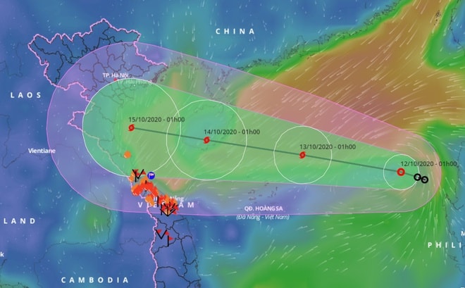 |
| Forecast of the path of the tropical depression in the East Sea. Photo: Vietnam Disaster Monitoring System |
At dawn on October 14, the eye of the storm was located right on the southern mainland of Hainan Island (China). The strongest wind was level 9, gusting to level 11. After that, the storm maintained its direction and speed, entering the southern waters of the Gulf of Tonkin.
The Meteorological Agency warned that the dangerous area in the East Sea in the coming hours is from 15.5 to 19.5 degrees north latitude and from 112.5 to 119.5 degrees east longitude. All vessels operating in the dangerous area are at high risk of being affected by strong gusts of wind.
The map of the tropical depression's path shows that when approaching the Gulf of Tonkin, the area of influence of this form spreads to provinces from the Northeast, North Central to part of the Central Central.
Experts recommend that people regularly update weather conditions and developments of tropical depressions to proactively develop response plans.
At the same time, floods in the Central region continue to be complicated. In the past 12 hours, rainfall recorded in Thua Thien - Hue, Da Nang, Quang Nam, Quang Ngai, was generally 150-300 mm, with some places over 380 mm.
Under the influence of the tropical convergence zone passing through the Central Central region combined with the activity of cold air, from now until October 13, the Central Central provinces will continue to have heavy rain.
Rainfall recorded in Quang Tri and Thua Thien - Hue ranged from 200-400 mm, with some places receiving over 500 mm. Provinces and cities such as Quang Binh and Da Nang had heavy rain of 100-200 mm. In addition, rain also spread to Ha Tinh, Quang Nam and Quang Ngai with an amount of 80-150 mm./.
.jpg "Hàng ngàn hộ dân xã Bích Hào, Thành Bình Thọ ngập sâu trong nước lũ")
.jpg "Tỉnh Nghệ An tổ chức dâng hoa, dâng hương tưởng niệm nữ chiến sĩ cách mạng Nguyễn Thị Minh Khai")


