Storm No. 8 will make landfall from Ha Tinh to Quang Tri, causing heavy rain in Nghe An.
Storm No. 8 is about 330 km east of the mainland provinces from Ha Tinh to Quang Tri.
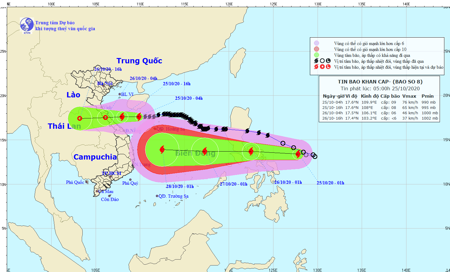
At 4:00 a.m. on October 25, the center of the stormat about 17.6 degrees North latitude; 109.9 degrees East longitude, about 330 km east of the mainland provinces from Ha Tinh to Quang Tri. The strongest wind near the storm center is level 9 (75-90 km/h).level 11.Radius of strong winds from level 6, gusting from level 8 or higher about 150 km from the center of the storm.
 |
| Development of storm No. 8 and tropical depression. |
It is forecasted that in the next 24 hours, the storm will move westward at 15-20 km per hour, make landfall in the provinces from Ha Tinh to Quang Tri and gradually weaken into a tropical depression.tropical depression.
At 4:00 a.m. on October 26, the center of the tropical depression was at approximately 17.5 degrees North latitude; 106.1 degrees East longitude, on the mainland of the provinces from Ha Tinh to Quang Tri. The strongest wind near the center of the tropical depression was level 6 (40-50 km/h).level 8 jerk.
In the next 24 to 36 hours, the tropical depression will move westward at a speed of 15-20 km per hour, moving inland and weakening into a low pressure area. At 4:00 p.m. on October 26, the center of the low pressure area will be at about 17.4 degrees North latitude; 103.2 degrees East longitude. The strongest wind in the center of the low pressure area will decrease to below level 6 (below 40 km/h).
Dangerous areas due to storms in the East Sea in the next 24 hours (strong winds of level 6 or higher, gusts of level 8 or higher): from latitude 15.5 to 20.0 degrees North; west of longitude 112.5 degrees East. All vessels operating in the dangerous area are at high risk of being affected by strong gusts of wind.
Forecast of strong winds at sea and on land: Today (October 25), in the Gulf of Tonkin, the sea from Quang Tri to Thua Thien Hue, the wind will gradually increase to level 6-7, near the storm's eye it will be level 8, gusting to level 10; waves will be 2-4m high; the sea will be rough; coastal areas from Ha Tinh to Thua Thien Hue will have strong winds of level 6, gusting to level 8.
 |
| Storm No. 8 is forecast to cause heavy rain in Nghe An on October 25 and 26. Illustrative photo |
Rain forecast: From now until October 26, in the provinces fromNghe AnIn Thua Thien Hue, there will be moderate to heavy rain with total rainfall of 50-150mm/period, in some places over 200mm.
Disaster risk warning level: level 3.

