Storm No. 9 makes landfall: From October 28 to 31, Nghe An is expected to have very heavy rain
(Baonghean.vn) - From October 28-31, the area from Nghe An to Quang Tri will have very heavy rain with total rainfall of 200-400mm/period; Southern Nghe An and Ha Tinh will have total rainfall of 500-700mm/period.
Storm level 16
National Center for Hydro-Meteorological Forecasting, at 4:00 a.m. on October 28,storm centerat about 14.4 degrees North latitude; 110.5 degrees East longitude, right on the sea off the coast of provinces and cities from Da Nang to Phu Yen. The strongest wind near the storm center is level 13 (135-150 km/h),level 1 jerk6.Radius of strong winds from level 6, gusting from level 8 or higher is about 280 km from the center of the storm; radius of strong winds from level 10, gusting from level 12 or higher is about 120 km from the center of the storm.
It is forecasted that in the next 12 hours, the storm will move in the West Northwest direction, traveling about 25 km per hour, entering the mainland from Da Nang to Phu Yen with the strongest wind at level 12-13, gusting to level 15, then gradually weakening. At 4:00 p.m. on October 28, the storm center will be at about 15.0 degrees North latitude; 107.6 degrees East longitude, in the Northern Central Highlands. The strongest wind near the storm center is level 8 (60-75 km/h),jerk10.
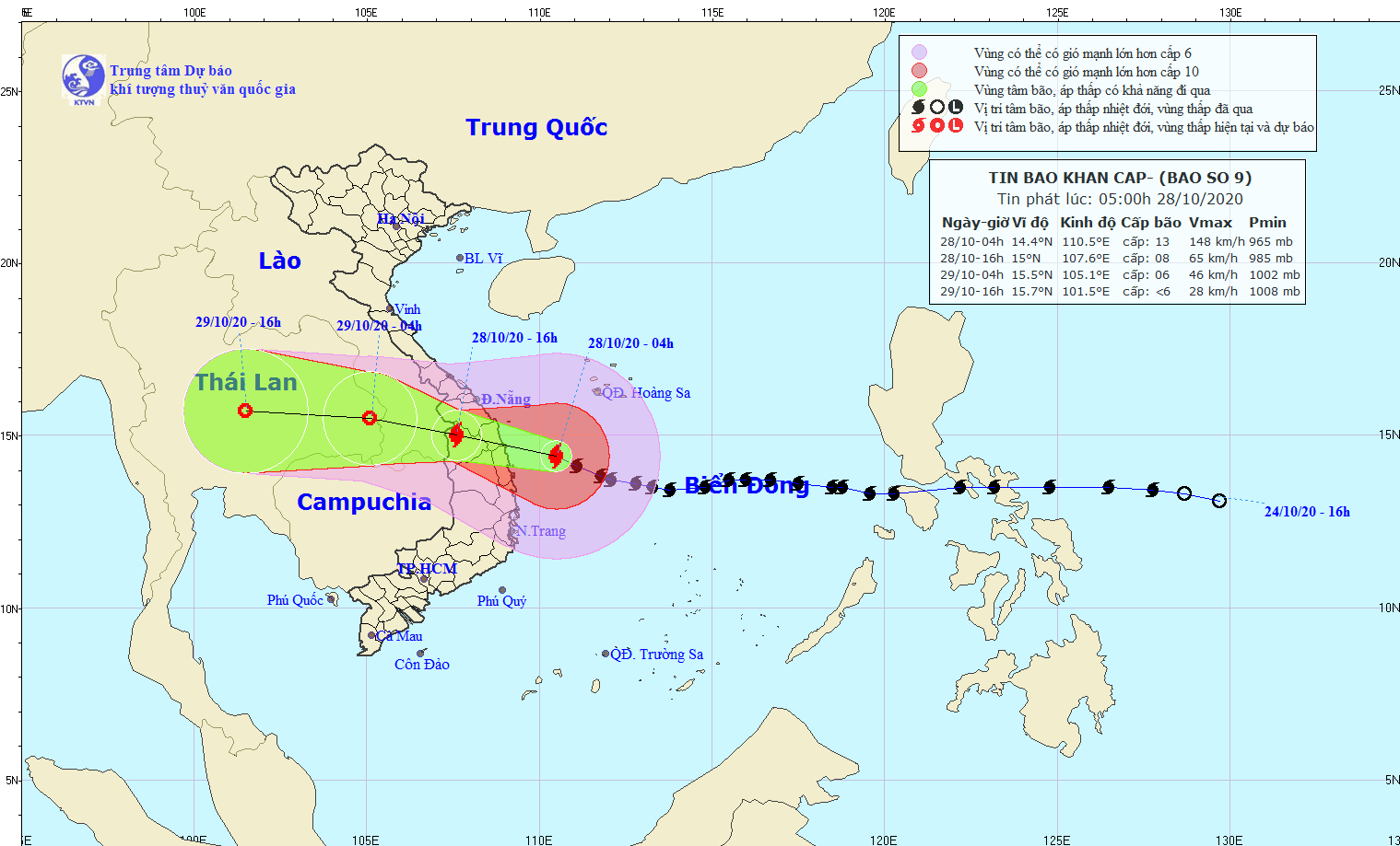 |
| Path of storm No. 9. Photo: National Center for Hydro-Meteorological Forecasting. |
In the next 12 to 24 hours, the storm will move in the West-Northwest direction, traveling 20-25 km per hour, moving deep into the mainland and gradually weakening into a tropical depression. At 4:00 a.m. on October 29, the center of the tropical depression was located at about 15.5 degrees North latitude; 105.1 degrees East longitude, in the area of Thailand. The strongest wind near the center of the tropical depression is level 6 (40-50 km/hour),jerk8.
Dangerous areas due to storms in the East Sea in the next 24 hours (strong winds from level 6 and above, gusts from level 8 and above): From latitude 11.0 to 18.0 degrees North; west of longitude 114.0 degrees East. All ships operating in the dangerous area are at high risk of being affected by strong gusts.
During the next 24 to 36 hours, the tropical depression will move west and weaken into a low pressure area.
Warning of strong winds and high waves at sea:The western sea area of the North and Central East Sea (including the sea area south of Hoang Sa archipelago) has strong winds of level 10-11, the area near the storm center has winds of level 12-13,level 1 jerk6; waves 8-10m high; rough sea.
The offshore sea area from Da Nang to Phu Yen (including Ly Son island district) has strong winds of level 9-11, near the storm center level 12-13, gusting to level 15; rough seas; waves from 6-8m high. The Gulf of Tonkin and the sea area from Quang Tri to Thua Thien Hue (including Con Co island) are affected by the circulation north of the storm combined with cold air, so there are northeast winds of level 8-9, gusting to level 11; very rough seas; waves from 4-6m high. The sea area from Khanh Hoa to Binh Thuan has strong winds of level 7, gusting to level 10; rough seas; waves from 3-5m high.
Coastal areas of provinces fromNghe AnFrom Thua Thien Hue to Binh Dinh, there is a possibility of storm surges of 0.5-1.5m high. Risk of flooding in low-lying areas, river mouths, and coastal lagoons from Thua Thien Hue to Quang Ngai.
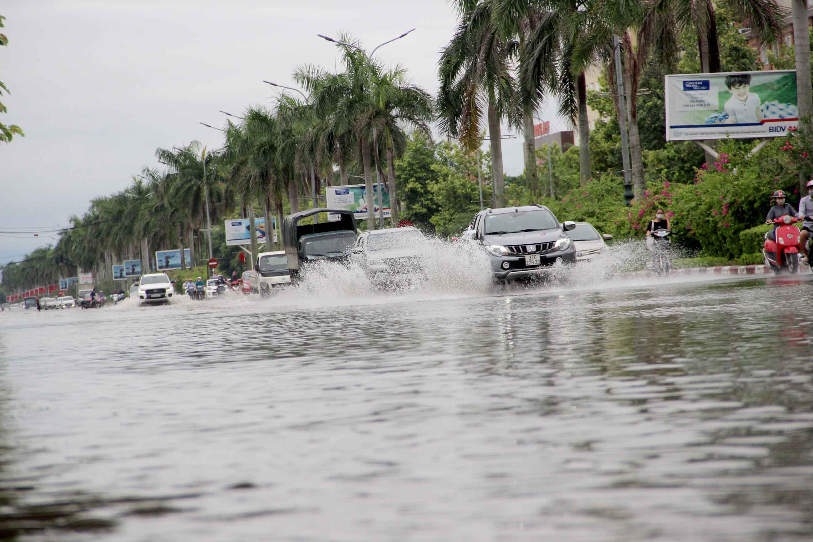 |
| Heavy rain caused flooding in Vinh City on September 19, 2020. Photo: Quang An |
Provinces and cities from Thua Thien Hue to Phu Yen have strong winds of level 8-10.level 12; In particular, the coastal mainland of the provinces and cities of Da Nang, Quang Nam, Quang Ngai, Binh Dinh has strong winds of level 11-13,level 15. Kon Tum and Gia Lai provinces have strong winds of level 7-8,level 10. The provinces of Quang Binh, Quang Tri, and Bac Khanh Hoa have strong winds of level 6-7,level 10.
In the area from Thua Thien Hue to Phu Yen, there is very heavy rain with total rainfall of 200-400mm/period; Northern Central Highlands 150-250mm/period.
Nghe An issues telegram to respond to storm No. 9
(Baonghean.vn) - On the morning of October 27, the Steering Committee for Natural Disaster Prevention and Search and Rescue of Nghe An province issued Official Dispatch 39/CD-UBND on focusing on responding to storm No. 9.
From 28-31/10 area fromNghe AnFrom Quang Tri, there is very heavy rain with total rainfall of 200-400mm/period; in particular, in Southern Nghe An and Ha Tinh, there is total rainfall of 500-700mm/period.
Disaster risk level due to storm No. 9: Level 4.
2 fishing boats missing
* Right now at the Frontline Command, Deputy Prime Minister Trinh Dinh Dung directs response to storm No. 9.
The delegation will then inspect the evacuation site in Lien Chieu District where many workers and students are staying.
At 6:00 a.m. on October 28, the storm center was about 300 km from Da Nang, 220 km from Quang Nam, 190 km from Quang Ngai, and 180 km from Phu Yen; wind level 13, gust level 16.
* Initial damage:
Besides the two sunken ships of Binh Dinh, there is currently no information about other damage.
* For at sea:
- Search and rescue of 02 lost contact ships of Binh Dinh.
- Resolutely call on 46 Binh Dinh ships to leave the dangerous area.
- Arrange forces and equipment to be on standby in the storm landing area to rescue ships in case of incidents.
- The management organization strictly implements the issued sea ban.