Storm Trami moves rapidly into the East Sea, continuing to strengthen
Storm Trami moves rapidly into the East Sea. At 1am on October 23, the strongest wind near the center of storm Trami was level 10, gusting to level 12, and continued to increase in intensity.
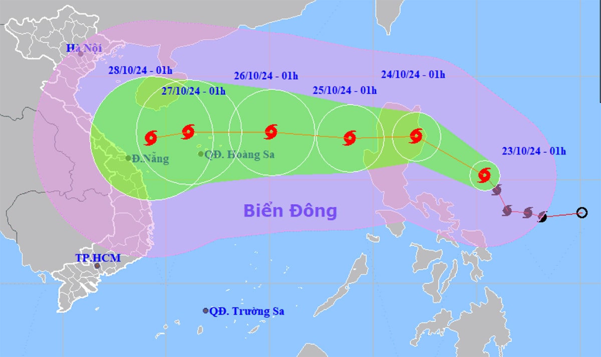
The National Center for Hydro-Meteorological Forecasting announced about storm Trami (Tra Mi) at 1:00 a.m. on October 23 in the sea east of the Philippines.
The storm has the strongest wind near the center of the storm reaching level 9 (75-88 km/h), gusting to level 11, moving northwest at a speed of about 20 km/h. It is forecasted that in the next 24 hours, the storm will move inland to the east of Luzon Island (Philippines) at a speed of 15 km/h.
At around 1am on October 25, the storm will change direction to the West, at a speed of 15 km/h, becoming the 6th storm of the year in the East Sea, with the strongest wind reaching level 10, gusting to level 12.
On October 26, the storm continued to move in a West-Northwest direction, 330 km east-northeast of Hoang Sa archipelago, with strong winds of level 11, gusting to level 14.
From the next 72 to 120 hours, the storm will move mainly to the West at a speed of 15-20 km/h and may strengthen.
At sea, the northeastern sea area of the North East Sea has strong winds of level 6-7, rough seas with waves of 4-6m high. Meanwhile, the sea area from Quang Tri to Binh Thuan, the central area of the East Sea, and the southeastern sea area of the East Sea also has strong winds and waves of 2-5m high.
From the afternoon of October 23, thunderstorms and tornadoes are likely to occur in the North East Sea. On October 24, winds may reach force 10-11 near the storm center, with waves 6-8 meters high, causing rough seas.
.jpg "Nghệ An ra công điện ứng phó với bão TRAMI")
")