Storm Vamco moves in a West Northwest direction, likely to strengthen.
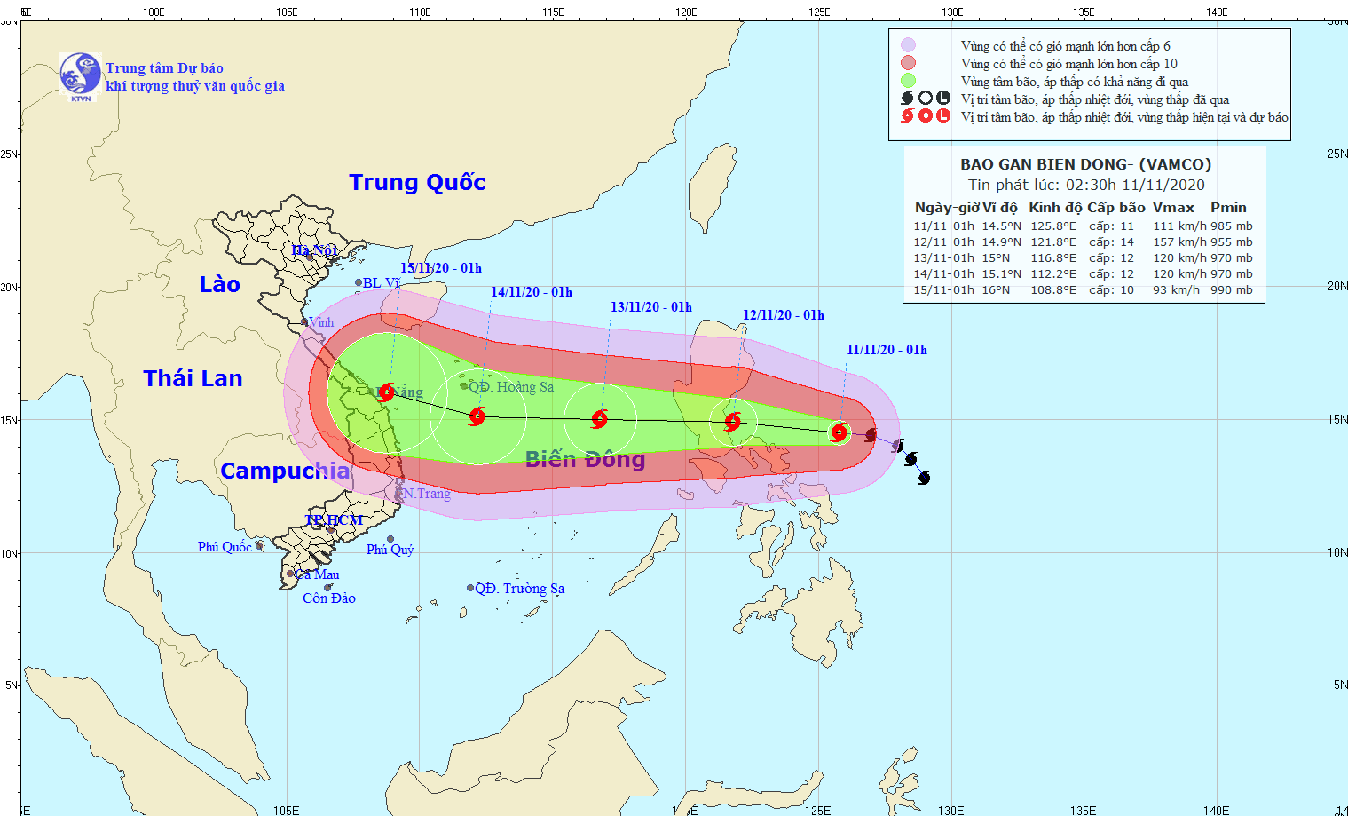
At 1:00 a.m. on November 11, the center of the storm was located at approximately 14.5 degrees North latitude; 125.8 degrees East longitude, approximately 480 km East Southeast of Luzon Island (Philippines). The strongest wind near the center of the storm was level 11 (100-115 km/h), gusting to level 14.
 |
| The movement of storm Vamco in the East Sea. |
Forecast in the next 24 hours, the storm moves in the West Northwest direction, about 20km per hour and has the potential to strengthen.
At 1:00 a.m. on November 12, the center of the storm was located at approximately 14.9 degrees North latitude; 121.8 degrees East longitude, right on the sea southeast of Luzon Island (Philippines). The strongest wind near the center of the storm was level 13-14 (135-165 km/h), gusting to level 16.
In the next 24 to 48 hours, the storm will move mainly westward, at 20-25km per hour, entering the East Sea.
At 1:00 a.m. on November 13, the center of the storm was at about 15.0 degrees North latitude; 116.8 degrees East longitude, about 630 km East Southeast of Hoang Sa archipelago. The strongest wind near the center of the storm was level 12 (115-135 km/h), gusting to level 14.
During the next 48 to 72 hours, the storm will move westward at 20-25km per hour. At 1:00 a.m. on November 14, the storm center will be at approximately 15.1 degrees North latitude; 112.2 degrees East longitude, approximately 220km south of the Paracel Islands. The strongest wind near the storm center is at level 12 (115-135km/h), gusting to level 15.
During the next 72 to 96 hours, the storm will move in a West Northwest direction, traveling about 15km per hour.
Heavy rain warning in South Central and Southern regions
Yesterday (November 10), due to the influence of the tropical depression that weakened from storm No. 12 after weakening into a low pressure area, in the provinces from the South of Ha Tinh to Ninh Thuan and the Central Highlands, there was heavy to very heavy rain with total rainfall (from 7:00 a.m. on November 10 to 1:00 a.m. on November 11) generally 40-80mm, especially in the provinces from Thua Thien Hue to Phu Yen and the North of the Central Highlands, there was very heavy rain with total rainfall from 100-180mm, in some places over 200mm. Some places had heavy rainfall such as: A Luoi (Hue) 111mm, Tra My (Quang Nam) 210mm, Ba To (Quang Ngai) 178mm, Tuy Hoa (Phu Yen) 114mm, An Khe (Gia Lai) 166mm, Lak (Dak Lak) 176mm, ...
Forecast: Due to the influence of the cold air strengthening combined with disturbances in the upper easterly wind zone, from now until November 12, the provinces/cities of Quang Tri, Thua Thien Hue, Da Nang, Quang Nam and Quang Ngai will have heavy to very heavy rain with total rainfall of 100-250mm, some places over 250mm; the provinces of Ha Tinh, Quang Binh and Binh Dinh will have moderate rain, heavy rain, some places very heavy rain with total rainfall of 50-100mm, some places over 100mm./.