Flash flood and landslide warning in Thanh Hoa, Nghe An, Ha Tinh
(Baonghean.vn) - Due to the influence of the tropical convergence zone combined with the subtropical high pressure that is encroaching strongly to the West, from July 14 to 16, a flood will appear in the upper reaches of the Red River - Thai Binh river system and rivers from Thanh Hoa to Ha Tinh.
According to the National Center for Hydro-Meteorological Forecasting, flood levels on rivers are as follows: on the upper reaches of Da River, Thao River and Lo River from 2-3m; on the upper reaches of Cau River, Thuong River, Luc Nam River, Hoang Long River, La River from 1-2m; on the upper reaches of Ma River, Ca River from 3-5m.
 |
| Many large cracks on the mountain top, causing landslides. Photo: Document |
During this flood, the flood peak on the upper reaches of the Da, Thao, Lo and Hoang Long rivers is likely to be at level 1; the flood peak on the Cau, Thuong, Luc Nam, Ma, Ca and La rivers will be below level 1.
Warning:There is a high risk of landslides and flash floods in mountainous areas of the provinces such as: Hoa Binh, Son La, Dien Bien, Lai Chau, Lao Cai, Yen Bai, Ha Giang, Cao Bang, Lang Son, Thanh Hoa, Nghe An, Ha Tinh.
Warning level of natural disaster risk due to floods, flash floods, landslides in mountainous areas of the North, Ha Tinh: Level 1;In Hoa Binh, Son La, Thanh Hoa, Nghe An provinces only: level 2.
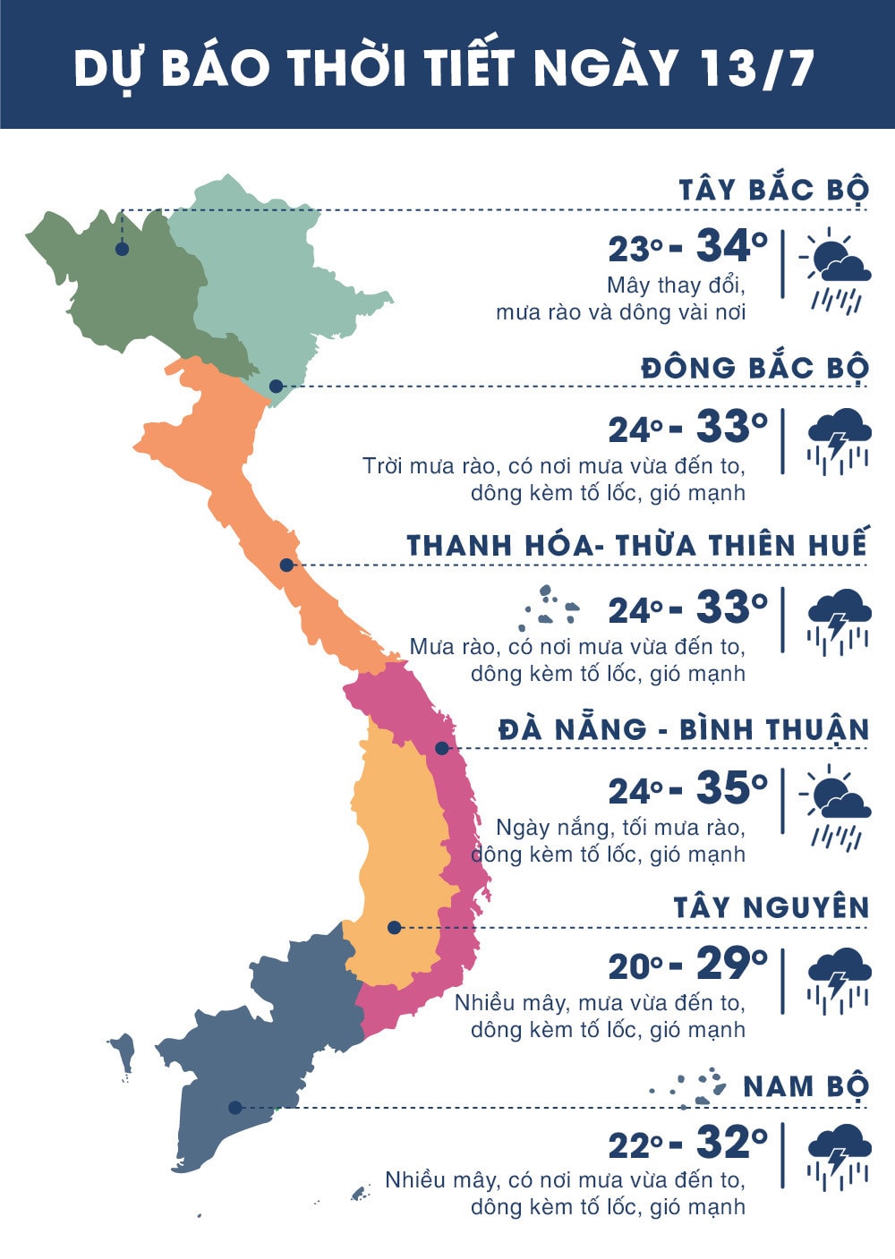 |
| Temperature on July 13, 2018 in regions across the country. Source news.zing.vn |
WARNING OF STRONG WINDS AND HIGH WAVES IN SEA AREAS
Currently (July 13),tropical convergence zone passes through the northern East Sea area.
Forecast:Due to the influence of the tropical convergence zone combined with the strong southwest monsoon, during today and tonight (July 13), the sea area of the southern Gulf of Tonkin; the central and southern East Sea (including the sea area of Truong Sa archipelago), the sea area from Binh Thuan to Ca Mau, Ca Mau to Kien Giang and the Gulf of Thailand will continue to have heavy thunderstorms. There is a possibility of tornadoes and strong gusts of wind during the thunderstorms.
The South China Sea area (including the Truong Sa archipelago), the sea area from Binh Thuan to Ca Mau continues to have strong southwest winds at level 6, sometimes level 7, gusting to level 9, waves 2-4m high; rough seas.Disaster risk level: level 1.