Storm and flood scenes exceed alert level 3 on rivers in some northern provinces, above historical flood levels
According to the National Center for Hydro-Meteorological Forecasting, in the next 12 hours, flood levels on the Thao River in Lao Cai will continue to decrease, remaining above alert level 3; in Bao Ha (Yen Bai), flood levels will continue to rise and remain above historical flood levels.
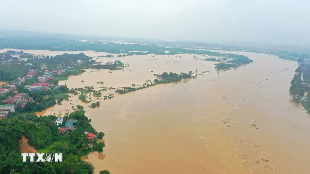
According to the National Center for Hydro-Meteorological Forecasting, in the past 12 hours, flood levels on the Thao River in Lao Cai are slowly receding, and rising in Bao Ha (Yen Bai); floods on the Lo River (Tuyen Quang, Vu Quang), Cau River (Thai Nguyen, Bac Ninh), Thuong River (Bac Giang), Thai Binh River (Hai Duong), and Red River (Hanoi); and Luc Nam River (Bac Giang) are slowly receding.
Water level at 01:00 on September 10, on Thao River in Lao Cai was 86.60m, 3.1m above alarm level 3; at Bao Ha was 61.62m, 0.69m above the historical flood level in 2008 (60.93m); at Yen Bai was 34.79m, 0.37m above the historical flood level in 1968 (34.42m).
On Cau River at Cau Gia Bay 28.81m, 0.67m above the historical flood level of 1959 (28.14m); at Dap Cau 5.92m, 0.38m below alarm level 3.
On Thuong River at Phu Lang Thuong 6.41m, 0.11m above alarm level 3; on Luc Nam River at Luc Nam 6.62m, 0.32m above alarm level 3.
On Lo River in Tuyen Quang 24.87m, above alarm level 2 0.87m; on Thai Binh River in Pha Lai 4.80m, below alarm level 2 0.2m; on Red River in Hanoi 8.26m, below alarm level 1 1.24m.
The National Center for Hydro-Meteorological Forecasting predicts that in the next 12 hours, flood levels on the Thao River in Lao Cai will continue to decrease and remain above alert level 3; in Bao Ha, Yen Bai, flood levels will continue to rise and remain above historical flood levels.
Floods on the Cau, Thuong, Red and Thai Binh rivers continue to rise. Floods on the Lo river are likely to peak. Floods on the Luc Nam river are receding slowly.
In the next 12-24 hours, the flood on Thao River in Lao Cai will continue to recede; at Bao Ha it will change slowly, at Yen Bai it will continue to rise and remain above historical flood levels. The flood on Red River and Thai Binh River will continue to rise, the flood on Cau and Thuong Rivers is likely to peak. The flood on Lo River and Luc Nam River will continue to recede.
The National Center for Hydro-Meteorological Forecasting warns that from now (September 10) to September 11, the flood on the Hoang Long River will continue to fall below alert level 1; there will be a flood on other rivers in the Northern region. During this flood, the flood peak on small rivers in the northern mountainous provinces, especially in the provinces of Lang Son, Cao Bang, Bac Kan, Bac Giang, Lao Cai, Yen Bai, Hoa Binh, Son La will rise to alert level 2-3, with some rivers above alert level 3.
The National Center for Hydro-Meteorological Forecasting also warns of the risk of flooding and the possibility of other natural disasters such as high risk of flooding in low-lying areas along rivers in the provinces of Lang Son, Cao Bang, Lao Cai, Yen Bai, Phu Tho, Bac Giang, Bac Kan, Thai Nguyen, Hoa Binh; flash floods and landslides on steep slopes in the mountainous areas of the North. Warning level of natural disaster risk due to floods: level 3.
Floods on rivers and streams cause flooding in low-lying areas along the rivers, encroachment of river banks, many areas of floating flats in the middle of the river are deeply flooded, affecting activities such as waterway transportation, aquaculture, agricultural production, people's lives and socio-economic activities in the downstream areas of Lo River and Red - Thai Binh River. Flood water levels in the downstream areas of Red - Thai Binh River remain high for many days, which can cause landslides along the river and affect the safety of dykes in the riverside areas of the Red - Thai Binh River Delta./.


