Warning of thunderstorms, flash floods and landslides in the North, Central region still has widespread heat
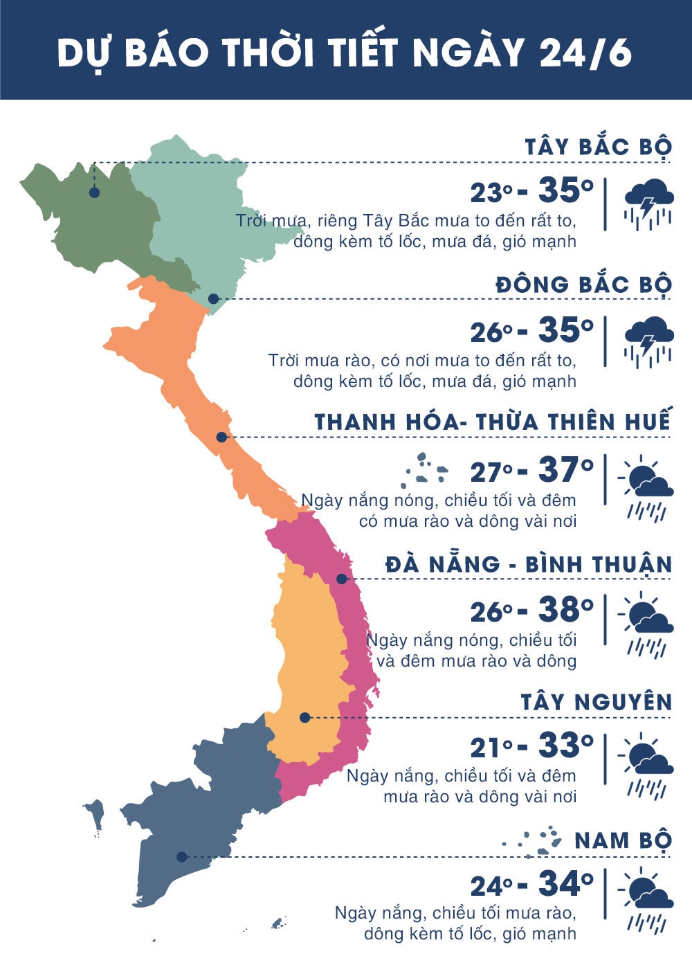
(Baonghean.vn) - Due to the influence of the southeastern edge of the low pressure area in the West with the southwest wind causing the foehn effect, today (June 24) and tomorrow (June 25), heat waves continue to appear widely in the coastal provinces of the Central region with the highest temperature of 35-38 degrees.
Yesterday (June 23)Widespread heat continues to occur in the coastal provinces of the Central region with the highest daily temperature commonly ranging from 35-37 degrees, some places above 37 degrees such as: Ha Tinh 37.2 degrees, Dong Hoi (Quang Binh) and Thua Thien-Hue 37.7 degrees, Tam Ky (Quang Nam) 37.5 degrees, Ba To (Quang Ngai) 38.0 degrees.
Currently (June 24), the low pressure area in the West has little change in intensity. According to forecasts, due to the influence of the Southeast edge of the low pressure area in the West with the Southwest wind causing the foehn effect, today and tomorrow (June 25), heat waves continue to appear widely in the coastal provinces of the Central region with the highest temperature of 35-38 degrees.
Time with temperature above 35 degrees from 11am-4pm. Heat disaster risk level: level 1.
Thunderstorm warning in the North, widespread heavy rain in the Northern mountainous areas
Due to the influence of a low pressure trough with an axis at about 23-25 degrees North latitude combined with a low vortex developing up to an altitude of 5000m in the area north of our country's border, last night (June 23) in the Northwest and the northern mountainous areas there was rain, moderate rain, and heavy rain in some places such as: Muong Te (Lai Chau) 30mm, Bac Quang (Ha Giang) 38mm, Cao Bang 36mm.
Currently (June 24), the low pressure trough has an axis at about 23-25 degrees North latitude, in the area north of our country's border, a low vortex continues to exist and develop up to an altitude of 5,000m.
According to the forecast, due to the influence of the low pressure trough combined with the low vortex analyzed above, which is tending to become stronger, from now until June 26, there will be widespread showers and thunderstorms in the North, with moderate rain, heavy rain, and some places with very heavy rain and strong thunderstorms (moderate rain, heavy rain and strong thunderstorms will be concentrated at night and in the morning). During the thunderstorm, there is a possibility of tornadoes, hail and strong gusts of wind.Disaster risk level: level 1.
 |
| Temperature on June 24, 2018 in regions across the country. Source: zing.vn |
FLASH FLOOD AND LANDSCAPE WARNING IN LAI CHAU, DIEN BIEN, HA GIANG AND CAO BANG PROVINCES
Currently:Through monitoring satellite cloud images, radar images, and lightning location images, it shows that there is a convective cloud area over the provinces of Lai Chau, Dien Bien, Ha Giang and Cao Bang causing rain.
Rainfall measured in the past 5 hours (from 8pm/June 23 to 1am/June 24) in Muong Te (Lai Chau): 30mm, Na Hu (Lai Chau): 24mm, Nam Giang (Lai Chau): 54mm, Muong Lay (Dien Bien): 11mm, Bac Quang (Ha Giang): 38mm, Cao Bang: 36mm. It is forecasted that in the next 3-6 hours, the areas of Lai Chau, Dien Bien, Ha Giang and Cao Bang provinces will continue to have rain, with rainfall ranging from 20-40mm.
Warning:In the next 3-6 hours, landslides and flash floods are at risk in Muong Te and Sin Ho districts (Lai Chau), Muong Lay (Dien Bien), Bac Quang (Ha Giang), Hoa An, Cao Bang Town (Cao Bang). Disaster risk warning level: Level 1.
.jpg "Kịp thời cứu sống cán bộ kiểm lâm bị ngạt, sốc nhiệt khi chữa cháy rừng ở Nghệ An")

