Disaster warning by satellite positioning
By developing the technology of the current satellite positioning system (GPS), American scientists have created an early warning system that provides accurate information about impending natural disasters.
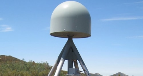 |
A GPS station is used in the emergency warning system for natural disasters.
Photo: Scripps Institution of Oceanography
A new type of warning system is being tested in southern California to warn people about the risk of flash floods, according to Nature World News. To increase the forecasting ability, scientists are upgrading GPS stations by integrating seismic sensors and meteorological sensors.
According to the research team, the GPS warning system predicts the time before an earthquake occurs 1–2 minutes, before a tsunami occurs about a few dozen minutes, about an hour before a flash flood, and about a few days before a severe winter storm.
By analyzing the shock waves that follow an earthquake, the new generation warning system is used to predict the strength of aftershocks that may follow.
In addition, this warning system can also create maps of the entire area affected by the earthquake and form the basis for tsunami forecasting.
GPS networks can forecast weather with timely and important information, thereby providing accurate data on any potential hazards that may occur. Experts will provide this warning information to the public and thereby contribute to limiting the impact of natural disasters.
These advances in predictive technology will be applied to public works, high-rise buildings and hospitals in the region to minimize damage when natural disasters occur, said Yehuda Bock, a researcher at the Scripps Institution of Oceanography.
According to Hanoi Moi


