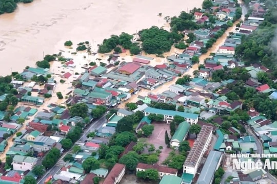
Update on urgent flood news on the upper reaches of Ca River (Nghe An)
(Baonghean.vn) - From the afternoon and night of August 17, floods on Thanh Hoa and Nghe An rivers continued to rise, especially the upstream of Ca River, rising very quickly.
The North Central region was directly affected by storm No. 4, so there was moderate rain, heavy rain, and thunderstorms in some places. Total rainfall from August 16 to 1:00 p.m. on August 17 was generally 75 - 150mm; some places were higher such as: Tay Hieu (Nghe An) 279mm, Quynh Luu (Nghe An) 250mm, Quy Hop (Nghe An) 246mm...
Water levels on rivers in Thanh Hoa and Nghe An are rising, especially Hieu River and the upper reaches of Ca River (Nghe An).
Water level at 16hAugust 17 on the following rivers:
On Hieu River at Quy Chau: 73.72m; At Nghia Khanh: 37.35m
On Ca River at Muong Xen: 143.03m (below historical water level: 2.46m); at Thach Giam: 69.61m (above historical water level: 0.71m); at Coconut: 21.16m (
Forecast,night 17 day 18/8, The low trough with axis through North Central Vietnam slowly lifts the axis to the North and gradually weakens, so the clouds change to mostly cloudy. At night and in the afternoon there will be scattered showers and thunderstorms, sunny during the day. Light wind.
From the afternoon and night of August 17, floods on Thanh Hoa and Nghe An rivers continued to rise.The upper reaches of the Ca River rise very quickly.In addition, because the hydroelectric reservoirs in the basin are regulated according to the Inter-reservoir Operation Procedure of the Ma and Ca Rivers, the flood peak on the Ma and Buoi Rivers (Thanh Hoa) is likely to be above level BĐII; the Chu River and the downstream of the Ma River are likely to be above level BĐI. The upstream of the Ca River will be at level BĐIII; the mid- and downstream of the Ca River will be above level BĐII.
By tomorrow morning (August 18),Water levels on rivers are as follows:
On Ca River at Thach Giam: 71.00m,higher than historical water level: 2.10m
At Con Cuong: 32.30m,lower than historical water level: 0.24m
At Dua: 23.60m, above BĐII level: 1.10m
At Nam Dan: 5.20m, below BĐI level: 0.20m
Warning:High risk of landslides and flash floods in mountainous and midland areas of districts: Con Cuong, Ky Son, Que Phong, Quy Chau, Quy Hop, Tuong Duong.


.jpg)


